Victor Sullivan wrote:Certainly an improvement. I hope you'll be fixing your signature though...
Yeah I will.
Moderator: Cartographers
![]() by The Bison King on Thu Nov 11, 2010 4:30 pm
by The Bison King on Thu Nov 11, 2010 4:30 pm
Victor Sullivan wrote:Certainly an improvement. I hope you'll be fixing your signature though...


![]() by The Bison King on Thu Nov 11, 2010 4:31 pm
by The Bison King on Thu Nov 11, 2010 4:31 pm
The Bison King wrote:
- Click image to enlarge.
- Click image to enlarge.
![]() by The Bison King on Tue Nov 16, 2010 3:05 pm
by The Bison King on Tue Nov 16, 2010 3:05 pm


![]() by Bruceswar on Tue Nov 16, 2010 3:26 pm
by Bruceswar on Tue Nov 16, 2010 3:26 pm


![]() by Victor Sullivan on Tue Nov 16, 2010 4:37 pm
by Victor Sullivan on Tue Nov 16, 2010 4:37 pm


![]() by The Bison King on Tue Nov 16, 2010 5:25 pm
by The Bison King on Tue Nov 16, 2010 5:25 pm
Bruceswar wrote:I like where this is going, but also I am not liking the floating land mass idea. Connect it into the US somehow.
Victor Sullivan wrote:Ack! Yosemite needs to be capitalized!!
![]() by lostatlimbo on Wed Nov 17, 2010 11:42 pm
by lostatlimbo on Wed Nov 17, 2010 11:42 pm
 .
. 


![]() by Vlasov on Thu Nov 18, 2010 1:54 am
by Vlasov on Thu Nov 18, 2010 1:54 am


![]() by natty dread on Thu Nov 18, 2010 6:26 pm
by natty dread on Thu Nov 18, 2010 6:26 pm


![]() by The Bison King on Fri Nov 19, 2010 5:47 pm
by The Bison King on Fri Nov 19, 2010 5:47 pm
![]() by The Bison King on Fri Nov 19, 2010 6:15 pm
by The Bison King on Fri Nov 19, 2010 6:15 pm
The stunning Channel Islands would be a nice island territory connecting from Santa Barbara.
You've left out the infamous Napa Valley - the most renowned region for growing wine in the US. I think Napa Valley deserves its own territory - set snuggly between Santa Rosa and Sacremento.
Fresno and Inyo Forest should not connect. There are no roads over the Sierras. Instead, I would recommend connecting Modesto and Yosemite (which is actually further West than Inyo Forest).
Lone Pine is a tiny highway village that only serves as a Portal to Mt. Whitney. Since that area is shown on the map where the northern half of Death Valley should be, I would drop it and just make Death Valley a taller territory. And yes, if you haven't seen it, Death Valley comes right up to the edge of the Sierras. Its one of the most amazing sights I've ever seen.
No Name could be China Lake or China Lake NWC.
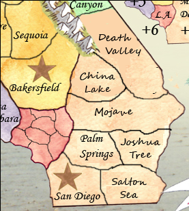
Being a border town (with Arizona) Needles seems abnormally large here and Palm Springs is out of place. You're also lacking the infamous Salton Sea and the one of a kind Joshua Tree NP. I would suggest rearranging this area as such:
Also - definitely need the Californian flag (and bear)
The Channel Islands lie closer to the LA/San Diego coast areas...maybe they could connect to San Diego and/or Malibu/South Bay?
Beverly Hills is actually located south and mostly east of "S.F.V." (San Fernando Valley) -- why not switch their names?
Also, some minor spelling/capitalization issues:
Redwood, not Red Wood
Yosemite, not yosemite
Big Sur, not Big sur
El Dorado, not El Derado
Santa Cruz, not Sant Cruz
the insets look blurry. Quite frankly they look like you just copypasted a part of the map and enlargened it for the insets... I think they are going to need some work.
not a big fan of the colour scheme. Particularly, northern california looks kinda dirty.
the title could use some work. It seems a bit too simplistic. Also the inset frames, as well as the brown frame around the map could use some ornamentation. They seem a bit boring now.
![]() by natty dread on Fri Nov 19, 2010 7:39 pm
by natty dread on Fri Nov 19, 2010 7:39 pm
... uh well I did just copy and paste them. There might be a way to make them look sharper in the program. If not I guess I'll just have to re-do them.
![]() by The Bison King on Fri Nov 19, 2010 7:42 pm
by The Bison King on Fri Nov 19, 2010 7:42 pm
natty_dread wrote:... uh well I did just copy and paste them. There might be a way to make them look sharper in the program. If not I guess I'll just have to re-do them.
See that's not good. You can't just enlarge raster graphics. You will lose detail. Pixels are square, and if you enlargen a bitmap an algorithm is used to resample the pixels into a larger grid - now this may work for simple patterns or gradients, but anything even slightly more detailed and you're going to end up with blurriness and artifacts.
Thus, the general rule with scaling bitmap graphics: downwards = ok, upwards = no-no.
I recommend just redoing them. If you start trying to enhance what you have now, chances are you'll end up doing more work for it...
![]() by natty dread on Fri Nov 19, 2010 8:02 pm
by natty dread on Fri Nov 19, 2010 8:02 pm
The Bison King wrote:Well... I think If I pull over the inset from the source image it will be large enough. The problem is I scaled it back up from an image I had already shrunk.
![]() by lostatlimbo on Sat Nov 20, 2010 7:57 pm
by lostatlimbo on Sat Nov 20, 2010 7:57 pm
The Bison King wrote:If I am going to add any territories These would be the two. You'll need to really sell me on why I should add them, not just on a "Because they're there" policy but with some evidence on how it will improve the game play.
The Bison King wrote:I don't want to drop Lone pine because I don't want the Sierra Nevada's to be that short on Territories.
The Bison King wrote:Where they connect is of little consequence, nor are where the roads are since this isn't a road map. I can definitely switch Yosemite to the hug the mountains on the west though.
![]() by The Bison King on Wed Nov 24, 2010 3:23 pm
by The Bison King on Wed Nov 24, 2010 3:23 pm

![]() by The Bison King on Wed Nov 24, 2010 3:30 pm
by The Bison King on Wed Nov 24, 2010 3:30 pm


![]() by saxitoxin on Wed Nov 24, 2010 10:07 pm
by saxitoxin on Wed Nov 24, 2010 10:07 pm
the names that are on this map are not of the period. While a pick axe may seem cliche, it does reflect the period. I do not see anything that reflects the 1800's. If you were to make Tahoe "The Ponderosa" then you would be headed in the right direction.
Pack Rat wrote:if it quacks like a duck and walk like a duck, it's still fascism
viewtopic.php?f=8&t=241668&start=200#p5349880


![]() by The Bison King on Wed Nov 24, 2010 10:21 pm
by The Bison King on Wed Nov 24, 2010 10:21 pm
![]() by saxitoxin on Wed Nov 24, 2010 10:35 pm
by saxitoxin on Wed Nov 24, 2010 10:35 pm
The Bison King wrote:Those names are a little complicated and would be hard to fit don't you think?
Pack Rat wrote:if it quacks like a duck and walk like a duck, it's still fascism
viewtopic.php?f=8&t=241668&start=200#p5349880
![]() by Victor Sullivan on Thu Nov 25, 2010 2:42 am
by Victor Sullivan on Thu Nov 25, 2010 2:42 am
saxitoxin wrote:The Bison King wrote:Those names are a little complicated and would be hard to fit don't you think?
just use font-face Courier 3
![]() by The Bison King on Thu Nov 25, 2010 11:59 am
by The Bison King on Thu Nov 25, 2010 11:59 am
![]() by natty dread on Fri Nov 26, 2010 6:33 am
by natty dread on Fri Nov 26, 2010 6:33 am
![]() by Vlasov on Fri Nov 26, 2010 9:35 am
by Vlasov on Fri Nov 26, 2010 9:35 am
![]() by Teflon Kris on Sat Nov 27, 2010 6:59 am
by Teflon Kris on Sat Nov 27, 2010 6:59 am


Users browsing this forum: No registered users
|
|||||||
| Conquer Club is not associated with RISK online in any way. Copyright © 2006-2025 by Big Wham LLC | |||||||


