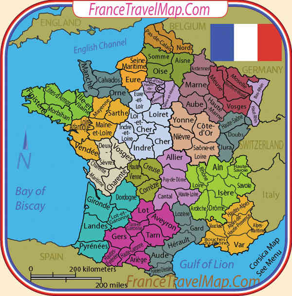
"DEPARTEMENTS": Regions are subdivided in 96 "Départements" (101 with DOM) : Circle on map
"PREFECTURES" Each "région" has a head department called "Préfecture". Underlined circle on map
Note that DOM are "régions" with only one "département". They count for both. DOM are on the side
France also have TOM ("Territoires d'outre-mer" = overseas territories) but they are not included in that map.
"List of Régions", "Départements" & "Préfectures"
Spoiler
Alsace :
67 Bas-Rhin
68 Haut-Rhin
Aquitaine :
24 Dordogne
33 Gironde
40 Landes
47 Lot-et-Garonne
64 Pyrénées-Atlantiques
Auvergne :
03 Allier
15 Cantal
43 Haute-Loire
63 Puy-de-Dôme
Basse-Normandie :
14 Calvados
50 Manche
61 Orne
Bourgogne :
21 Côte-d'Or
58 Nièvre
71 Saône-et-Loire
89 Yonne
Bretagne :
22 Côtes-d'Armor
29 Finistère
35 Ille-et-Vilaine
56 Morbihan
Centre :
18 Cher
28 Eure-et-Loir
36 Indre
37 Indre-et-Loire
41 Loir-et-Cher
45 Loiret
Champagne-Ardenne :
08 Ardennes
10 Aube
51 Marne
52 Haute-Marne
Corse :
2A Corse-du-Sud
2B Haute-Corse
Franche-Comté :
25 Doubs
39 Jura
70 Haute-Saône
90 Territoire de Belfort
Haute-Normandie :
27 Eure
76 Seine-Maritime
Île-de-France :
75 Paris
77 Seine-et-Marne
78 Yvelines
91 Essonne
92 Hauts-de-Seine
93 Seine-Saint-Denis
94 Val-de-Marne
95 Val-d'Oise
Languedoc-Roussillon :
11 Aude
30 Gard
34 Hérault
48 Lozère
66 Pyrénées-Orientales
Limousin :
19 Corrèze
23 Creuse
87 Haute-Vienne
Lorraine :
54 Meurthe-et-Moselle
55 Meuse
57 Moselle
88 Vosges
Midi-Pyrénées :
09 Ariège
12 Aveyron
31 Haute-Garonne
32 Gers
46 Lot
65 Hautes-Pyrénées
81 Tarn
82 Tarn-et-Garonne
Nord-Pas-de-Calais :
59 Nord
62 Pas-de-Calais
Pays de la Loire :
44 Loire-Atlantique
49 Maine-et-Loire
53 Mayenne
72 Sarthe
85 Vendée
Picardie :
02 Aisne
60 Oise
80 Somme
Poitou-Charentes :
16 Charente
17 Charente-Maritime
79 Deux-Sèvres
86 Vienne
Provence-Alpes-Côte d'Azur :
04 Alpes-de-Haute-Provence
05 Hautes-Alpes
06 Alpes-Maritimes
13 Bouches-du-Rhône
83 Var
84 Vaucluse
Rhône-Alpes :
01 Ain
07 Ardèche
26 Drôme
38 Isère
42 Loire
69 Rhône
73 Savoie
74 Haute-Savoie
I have to do the bonuses and set the airports but you can already see the new design and let me know about:
MAP 2.0
- Click image to enlarge.

This is the new map : FRANCE: BAMBOO JACK STYLE
Total of territories: 114 (101 "départements" + 13 airports: one is missing in ALSACE on the map)
"Régions" can be entered only by their "préfectures" (underlined circles) or by airports (Airports can attack each other).
Préfectures can attack adjacent 'préfectures', or 'départements' in their own 'région'.
Airports are in 'préfectures' except for Paris (Roissy-CdG = 95) and Nice (06). Airports can only attack one territory in the 'région' they belong to.
Airports are territories and reset to neutral after playing.
22 starting points in total. Starting points start with 5 troops (Maybe we could set 3 troops with a + 2 autodeploy too)
DOM (5 territs on the side) start neutral and are +3 or +5 autodeploy...(I don't know yet). No ports anymore.
Bonus will be set later. There will be region bonuses (all territ in the same region = bonus) and colored bonus (hold 'préfectures' of the same color = bonus)
- Click image to enlarge.

OLD MAPS AND GAMEPLAY
First of all, I know there already is a map of france (geographic one) so please don't tell me that or I will have to argument about it. And you don't want to. 
I'm sure the previous creator gave work and time for it.
So , this is the subject : FRANCE - Geographic, not historical.
France is divided in 22 (27 with dom)"Régions" and subdivided in 96 (101 with dom) "Départements" :
There are also 8 Ports and 9 Airports to travel from north to south and from east to west quickly.
Total of territories on this map = 114 (96+8+9+Gibraltar) (+10 if we include DOM)
They can be reached only by the region they belong to.
Those territs are neutral and remain neutral after a turn.
All those territs are separetely written on board (green and blue square)
Airport can reach directly any other airport.
Port are divided in two section : Antlantic and mediterranean. To jump from one to another, the player will have to go through Gibraltar (wich will be seen in POrts tab)
Is it possible to reset to neutral when a player END turn or only when he starts turn?
I made a quick map, just to show you the main idea and the gameplay. I'll do it more nicer when I'll receive a go for it.
I just drawed three regions with connections and region's numbers (north west) to show how departments will join eachothers.
This is the main idea. I let you have a look on it before I comment or answer any question about it.
UPDATE Port and Airport Connections
List of ports and airports with "départements" they belong to.
PORTS: From north to south
Calais 62
Cherbourg 50
Brest 29
La Rochelle 17
Bayonne 64
Sète 34
Marseille 13
Bastia 2B
Gibraltar (not French): is the passage from mediterranean to atlantic.
AIRPORTS: From north to south
Lille Lesquin 59
Roissy Charles-De-Gaulle 95
Nantes Atlantique 44
Basel Mulhouse 68
Bordeaux Mérignac 33
Lyon St-Exupéry 69
Toulouse Blagnac 31
Nice Côte-d'Azur 06
Ajaccio Napoléon-Bonaparte 2A
UPDATE More about gameplay
I thought to have like 24 starting points. No auto deploy on it, only starting points. 24 can be divided for any game (numbers of players). 1vs1 will be 12 territ each and 8 players will be 3 territ each.
That avoid to start a 1vs1 with like 50 territories and + 16 reinforcment on first round which is unfair.
24 territories will be one per region (22 in total) except for two region who will have 2 starting points. Those are 2 Régions with 8 départements on it. Rhones-Alpes & Midi-Pyrénées. Ile-de-France also have 8 territ but will have only one starting point: Paris.
UPDATE And if we add DOM
Ok, you should know that France has also DOM (Départements d'outre-mer) which are departments in other parts of the world. We now have 5 DOM (including Mayotte since 2011).
ABOUT THE GAMEPLAY : DOM are reachable only by planes, they start as neutral and once conquer, they have an autodeploy +5. All DOM can be reached by Roissy CDG (Paris airport) and only by 2 other airport from france.
For exemple, Guadeloupe airport will have connection with Roissy CDG + Lille Lesquin + Bordeaux Merignac
while Martinique will have Roissy CDG too but with Nice CA + Nantes Atlantique (instead Lille & Bordeaux).
This is the new map.
I'm sure the previous creator gave work and time for it.
So , this is the subject : FRANCE - Geographic, not historical.
France is divided in 22 (27 with dom)"Régions" and subdivided in 96 (101 with dom) "Départements" :
There are also 8 Ports and 9 Airports to travel from north to south and from east to west quickly.
Total of territories on this map = 114 (96+8+9+Gibraltar) (+10 if we include DOM)
They can be reached only by the region they belong to.
Those territs are neutral and remain neutral after a turn.
All those territs are separetely written on board (green and blue square)
Airport can reach directly any other airport.
Port are divided in two section : Antlantic and mediterranean. To jump from one to another, the player will have to go through Gibraltar (wich will be seen in POrts tab)
Is it possible to reset to neutral when a player END turn or only when he starts turn?
I made a quick map, just to show you the main idea and the gameplay. I'll do it more nicer when I'll receive a go for it.
I just drawed three regions with connections and region's numbers (north west) to show how departments will join eachothers.
This is the main idea. I let you have a look on it before I comment or answer any question about it.
- Click image to enlarge.

List of ports and airports with "départements" they belong to.
PORTS: From north to south
Calais 62
Cherbourg 50
Brest 29
La Rochelle 17
Bayonne 64
Sète 34
Marseille 13
Bastia 2B
Gibraltar (not French): is the passage from mediterranean to atlantic.
AIRPORTS: From north to south
Lille Lesquin 59
Roissy Charles-De-Gaulle 95
Nantes Atlantique 44
Basel Mulhouse 68
Bordeaux Mérignac 33
Lyon St-Exupéry 69
Toulouse Blagnac 31
Nice Côte-d'Azur 06
Ajaccio Napoléon-Bonaparte 2A
UPDATE More about gameplay
I thought to have like 24 starting points. No auto deploy on it, only starting points. 24 can be divided for any game (numbers of players). 1vs1 will be 12 territ each and 8 players will be 3 territ each.
That avoid to start a 1vs1 with like 50 territories and + 16 reinforcment on first round which is unfair.
24 territories will be one per region (22 in total) except for two region who will have 2 starting points. Those are 2 Régions with 8 départements on it. Rhones-Alpes & Midi-Pyrénées. Ile-de-France also have 8 territ but will have only one starting point: Paris.
UPDATE And if we add DOM
Ok, you should know that France has also DOM (Départements d'outre-mer) which are departments in other parts of the world. We now have 5 DOM (including Mayotte since 2011).
ABOUT THE GAMEPLAY : DOM are reachable only by planes, they start as neutral and once conquer, they have an autodeploy +5. All DOM can be reached by Roissy CDG (Paris airport) and only by 2 other airport from france.
For exemple, Guadeloupe airport will have connection with Roissy CDG + Lille Lesquin + Bordeaux Merignac
while Martinique will have Roissy CDG too but with Nice CA + Nantes Atlantique (instead Lille & Bordeaux).
This is the new map.
- Click image to enlarge.

- Click image to enlarge.