Re: 1v1: Promontory Summit [10.3.14] BETA
Moderator: Cartographers
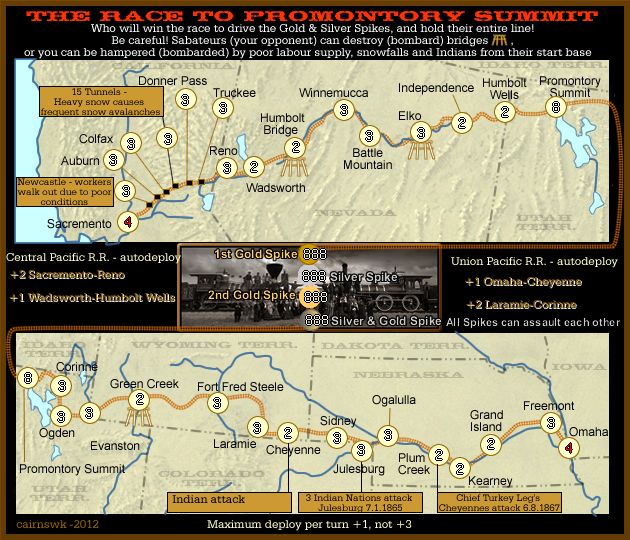
Re: Race to Promontory Summit [13.12.12] V4-Injuns & 4 Spike
![]() by Jippd on Thu Dec 13, 2012 11:44 pm
by Jippd on Thu Dec 13, 2012 11:44 pm
I forsee a problem with this map on trench and 1 v 1. If I started on the bottom and went first I feel like it would be very easy for me to keep the top half on their base for a while. I would slowly creep forward and be safe until plum creek from bombardment..by that time autodeploys would save me while I utilize attackers dice advantage to keep the top half on their base
-

 Jippd
Jippd
- Posts: 1384
- Joined: Sun Aug 03, 2008 9:05 pm


Re: Race to Promontory Summit [13.12.12] V4 - With Indians
![]() by cairnswk on Fri Dec 14, 2012 12:12 am
by cairnswk on Fri Dec 14, 2012 12:12 am
Bumped...

* Pearl Harbour * Waterloo * Forbidden City * Jamaica * Pot Mosbi
-

cairnswk
- Posts: 11510
- Joined: Sat Feb 03, 2007 8:32 pm
- Location: Australia


Re: Race to Promontory Summit [13.12.12] V4-Injuns & 4 Spike
![]() by cairnswk on Fri Dec 14, 2012 12:46 am
by cairnswk on Fri Dec 14, 2012 12:46 am
Jippd wrote:I forsee a problem with this map on trench and 1 v 1. If I started on the bottom and went first I feel like it would be very easy for me to keep the top half on their base for a while. I would slowly creep forward and be safe until plum creek from bombardment..by that time autodeploys would save me while I utilize attackers dice advantage to keep the top half on their base
OK. From the vidoes and research readings, there was a lot of challenges gaining momentum for these two lines.
From http://www.railswest.com/pacificrailroad.html
Central Pacific Railroad Begins Construction in Sacramento
The Central Pacific Railroad broke ground at Front and K Streets in Sacramento on January 8, 1863, the Union Pacific a Omaha on December 2, 1863. The Central Pacific laid its first rail on October 26. The Central Pacific's first locomotive, No. 1 Governor Stanford, was placed in service on November 10. Most of the rail, supplies and equipment for the Central Pacific had to be shipped around Cape Horn at the tip of South America. It typically took from three to seven months or longer for shipments to arrive from the East.
Progress was slow for both companies during the war years with price of materials high and labor scarce. The Railroad Act of 1864 doubled the resources made available to the railroads by the previous act.
The Central Pacific pushed their rails 18 miles east of Sacramento to Roseville by February 1864 and train service began in April. Track was completed 31 miles to Newcastle and trains began running in June. Progress slowed as track crews entered the Sierra Nevada foothills. Winter weather and the increasing necessity for tunneling in the mountains began to slow progress further. The CPRR reached Clipper Gap, 43 miles away, was reached on June 10, 1865, and Colfax, 55 miles away, was reached on September 10, 1865.
The work began with the surveyors who selected the best route. The graders followed behind the surveyors, digging through the hills, blasting tunnels, filling in the valleys and building bridges. All grading and track laying was done by hand, using picks and shovels, black powder for blasting, and mule carts to hall the debris away. Behind the graders followed the track layers, laying down the hand hewn wooden ties and rails. the rails were measured to make sure they were exactly the right distance apart then spiked into place using specially designed hammers.
Silver was discovered in Nevada in 1865. Many able bodied men left for Nevada to search for silver, depleting the work force of the Central Pacific. The Central Pacific had hired only white men (mostly Irish) up to this point in time. Faced with a shortage of white workers willing to work on the railroad, Charles Crocker, amid much dispute, began hiring Chinese workers to fill in for the white labor shortage. Although initially thought to be too weak or fragile to do this type of work, the Chinese workers proved to be very efficient and industrious. The decision was made to hire as many as could be found in California, and others were imported from China. The construction crews worked from sunrise to sunset, six days in the week.
An estimated 6000 Chinese workers faced a formidable challenge blasting rock and cutting a roadbed through the Sierras. The rock was so hard that as little as seven to eight inches of progress were made in a day, although the use of nitroglycerin did speed up the process in 1866.
Watertower and windmill at LaramieIn December 1866 the Central Pacific opened 92 miles to Cisco, California. The first CPRR locomotive crossed the California - Nevada border on December 13, 1867. The mountain work was soon completed, and the CP was pushing eastward across the Nevada plane, following the Truckee River to Wadsworth, then the California Trail and Humbolt River eastward toward Utah. Tracks were completed 10 miles east of Elko, Nevada by the end of 1868.
To reduce conflict with the local Native American groups James Strobridge, the construction superintendent of the Central Pacific, offered the Paiute and Shoshone Indians free rides on the trains. The Central Pacific also employed some Native Americans building the railroad.
Union Pacific Begins Laying Track in Omaha
The Union Pacific Railroad was incorporated on July 1, 1862 in the wake of the Pacific Railroad Act of 1862. Its dominant stockholder and partner was Thomas C. Durant who was also selected as Vice President.
The determination for the starting point of the Union Pacific was left up to President Lincoln who selected Council Bluffs, Iowa, on the East bank of the Missouri River, based on the advise of his former client Thomas Durant. Council Bluffs was a major outfitting point on the Missouri for the Oregon Trail with a lively steamboat trade. Omaha, Nebraska was directly across the river. Council Bluffs and Omaha were well north of the Civil War fighting taking place in Missouri, was the shortest route to the South Pass break in the Rockies in Wyoming, and would follow a fertile river that would encourage settlement.
Durant created a separate company, Crédit Mobilier of America, to cary out the construction of the railroad, to limit the liability of stockholders and to maximize profits from construction. The company was the sole bidder for construction contracts from Union Pacific, with the substantial fees being paid by federal subsidies. The company also provided discounted shares of stock to members of Congress who agreed to support additional funding.
UP Construction at Green River, Wyoming Winter 1868 Citadel Rock is in the background (A. J. Russell)The Union Pacific didn't start laying rail in Omaha until July 1865. By January 1866, the Central Pacific had laid 60 miles of track, and the Union Pacific had only laid 40 miles of track to Fremont, Nebraska. The tracks roughly paralleled the Oregon Trail and the Platte River to North Platte, which was reached in December 1866. From North Platte the tracks followed the South Platte River to Julesburg, Colorado Territory, which was reached in June 1867.
The Union Pacific crews were led by Grenville Dodge, the Chief Engineer, and Jack Casement who supervised the Union Pacific construction. Crews were made up of primarily Irish immigrants and Civil War veterans. Others included Native Americans, German and English immigrants, and a few local workers including Mormons in Utah. In addition to the track layers, construction also required hundreds of blacksmiths, carpenters, engineers, masons, surveyors, teamsters, telegraphers, and even cooks.
The Union Pacific progress was often resisted by Native American Indian groups who opposed the incursion of the work gangs and railroad into their hunting areas. They saw the construction of the railroad as a violation of their treaties with the United States. War parties began to raid the moving labor camps that followed the progress of the line. Union Pacific responded by increasing security and by hiring marksmen to kill American Bison - which were both a physical threat to trains and the primary food source for many of the Plains Indians.
The Union Pacific reached Cheyenne, Wyoming in November 1867; and had completed 450 miles of track to the Utah - Wyoming border by the end of 1868.
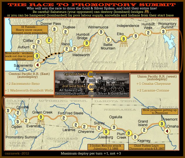
Maybe we can take the Indian attack from Cheyenne and place the bombardment at Freemont...since that first point was roughly the same for both RRs.
* Pearl Harbour * Waterloo * Forbidden City * Jamaica * Pot Mosbi
-
cairnswk
- Posts: 11510
- Joined: Sat Feb 03, 2007 8:32 pm
- Location: Australia
Re: Race to Promontory Summit [13.12.12] V4-Injuns & 4 Spike
![]() by Jippd on Fri Dec 14, 2012 12:53 am
by Jippd on Fri Dec 14, 2012 12:53 am
That will help make it more balanced. I almost feel that this map should be a mirror image though. If it is 1 v 1 and each player starts on one end with only one spot to win in then there is only way to make the drop fair for both sides and that is to make them mirror images. If you made this change my next argument would be for both sides its two neutrals to next bombard point but then the north has 4 spots to go through and the south only 1 to get to the next bombardment spot. I'd rather be in the north then so I can advance easier.
-
Jippd
- Posts: 1384
- Joined: Sun Aug 03, 2008 9:05 pm
Re: Race to Promontory Summit [13.12.12] V4-Injuns & 4 Spike
![]() by cairnswk on Fri Dec 14, 2012 1:11 am
by cairnswk on Fri Dec 14, 2012 1:11 am
Jippd wrote:That will help make it more balanced. I almost feel that this map should be a mirror image though. If it is 1 v 1 and each player starts on one end with only one spot to win in then there is only way to make the drop fair for both sides and that is to make them mirror images.
i think you can make it a mirror image to some extent by having the same number of bombardments. But the conditions can be reflected by differing places of bombardment, and the balance of neutral amount placement.
which i will do to even this start out...If you made this change...
...my next argument would be for both sides its two neutrals to next bombard point but then the north has 4 spots to go through and the south only 1 to get to the next bombardment spot. I'd rather be in the north then so I can advance easier.
think of top map as west, and bottom map as east....not north and south...
east section UPRR...3 places to advance to Plum Creek from Freemont before next bombardment...6 neutrals to overcome
west section CPRR...2 places to advance to 15 tunnels (and this has to be used as harzard)...9 neutrals to overcome -> needs to be reduced to 6.
similar sort of maths needs to balance everthing out... to make it fair, and even then there is still the luck of the dice and who goes first.
* Pearl Harbour * Waterloo * Forbidden City * Jamaica * Pot Mosbi
-
cairnswk
- Posts: 11510
- Joined: Sat Feb 03, 2007 8:32 pm
- Location: Australia
Re: Race to Promontory Summit [14.12.12] V5-Neutrals
![]() by cairnswk on Fri Dec 14, 2012 2:11 am
by cairnswk on Fri Dec 14, 2012 2:11 am
Plan for neutrals and bombardments...
UPRR (east) 15 spaces
CPRR (west) 15 spaces
1st bombardment
UPRR (east) - Freemont - N3 - 1 space from start
CPRR (west) - Newcastle - N3 - 1 space from start
2nd bombardment
UPRR (east) - Plum Creek - 3 spaces from Freemont - 6N to conquer
CPRR (west) - 15 tunnels - 3 spaces from Newcastle - 6N to conquer
3rd bombardment
UPRR (east) - Julesberg - 2 spaces from Plum Creek - 6N to conquer
CPRR (west) - Humbolt Bridge - 5 spaces from 15 tunnles - 11N to conquer (reflects conditions in moutains, but not too hard)
4th bomardments
UPRR (east) - Green Creek - 5 spaces from Julesberg - 11N to conquer
CPRR (west) - Elko - 3 spaces from Humbolt Bridge - 9N to conquer
Promontory Summit
UPRR (east) - 4 spaces from Green Creek - 10N
CPRR (west) - 3 spaces from Elko - 8N
total neutrals on each side to conquer - 38
Version 5.
* Pearl Harbour * Waterloo * Forbidden City * Jamaica * Pot Mosbi
-
cairnswk
- Posts: 11510
- Joined: Sat Feb 03, 2007 8:32 pm
- Location: Australia
Re: Race to Promontory Summit [14.12.12] V5-Neutrals
![]() by Jippd on Fri Dec 14, 2012 3:01 am
by Jippd on Fri Dec 14, 2012 3:01 am
I'm talking about going from the 2nd spot that can be bombarded to the third spot on each side. West has an advantage because it is 3 places away whereas the east move one spot and then is on a bombardable region again.
-
Jippd
- Posts: 1384
- Joined: Sun Aug 03, 2008 9:05 pm
Re: Race to Promontory Summit [14.12.12] V5-Neutrals
![]() by Oneyed on Fri Dec 14, 2012 3:06 am
by Oneyed on Fri Dec 14, 2012 3:06 am
looks good.
change bombadment from Julesburg to Chayenne, I think. then it will be more balanced, but still not the same.
Oneyed
change bombadment from Julesburg to Chayenne, I think. then it will be more balanced, but still not the same.
Oneyed
-

Oneyed
- Posts: 1058
- Joined: Sat Dec 10, 2011 12:29 pm


Re: Race to Promontory Summit [14.12.12] V5-Neutrals
![]() by cairnswk on Fri Dec 14, 2012 3:07 am
by cairnswk on Fri Dec 14, 2012 3:07 am
Jippd wrote:I'm talking about going from the 2nd spot that can be bombarded to the third spot on each side. West has an advantage because it is 3 places away whereas the east move one spot and then is on a bombardable region again.
so it is balanced by neutrals between each spot. I told you that we are not going to have evenly spaced bombardment spots throughout the map. it would make it far too clinical for my liking
Last edited by cairnswk on Fri Dec 14, 2012 3:10 am, edited 1 time in total.
* Pearl Harbour * Waterloo * Forbidden City * Jamaica * Pot Mosbi
-
cairnswk
- Posts: 11510
- Joined: Sat Feb 03, 2007 8:32 pm
- Location: Australia
Re: Race to Promontory Summit [14.12.12] V5-Neutrals
![]() by cairnswk on Fri Dec 14, 2012 3:09 am
by cairnswk on Fri Dec 14, 2012 3:09 am
Oneyed wrote:looks good.
change bombadment from Julesburg to Chayenne, I think. then it will be more balanced, but still not the same.
Oneyed
that is a possibility, but once again we are getting towards being too clinical and totally evenly spaced, and gees, to we really have to go there, when there are other options??
* Pearl Harbour * Waterloo * Forbidden City * Jamaica * Pot Mosbi
-
cairnswk
- Posts: 11510
- Joined: Sat Feb 03, 2007 8:32 pm
- Location: Australia
Re: Race to Promontory Summit [14.12.12] V5-Neutrals
![]() by Oneyed on Fri Dec 14, 2012 3:20 am
by Oneyed on Fri Dec 14, 2012 3:20 am
cairnswk wrote:that is a possibility, but once again we are getting towards being too clinical and totally evenly spaced, and gees, to we really have to go there, when there are other options??
too clinical? you can do it as no by set up neutrals. here is question what is worst: to attack 2 times 3 neutrals or 4 times 2 neutrals?
I am afraid that Julesburg will gives to east player advantage.
Oneyed
-
Oneyed
- Posts: 1058
- Joined: Sat Dec 10, 2011 12:29 pm
Re: Race to Promontory Summit [14.12.12] V5-Neutrals
![]() by cairnswk on Fri Dec 14, 2012 4:19 am
by cairnswk on Fri Dec 14, 2012 4:19 am
Oneyed wrote:cairnswk wrote:that is a possibility, but once again we are getting towards being too clinical and totally evenly spaced, and gees, to we really have to go there, when there are other options??
too clinical? you can do it as no by set up neutrals. here is question what is worst: to attack 2 times 3 neutrals or 4 times 2 neutrals?
...Oneyed
It depends on how many i am attacking with, and how my luck is running.
* Pearl Harbour * Waterloo * Forbidden City * Jamaica * Pot Mosbi
-
cairnswk
- Posts: 11510
- Joined: Sat Feb 03, 2007 8:32 pm
- Location: Australia
Re: Race to Promontory Summit [14.12.12] V5-Neutrals
![]() by codierose on Fri Dec 14, 2012 6:21 am
by codierose on Fri Dec 14, 2012 6:21 am
do have to hold all 4 spikes and all your line for objective or 1 gold 1 silver for your side
-
codierose
- Posts: 1561
- Joined: Sun Jul 27, 2008 5:50 pm
- Location: RANDOMBULLSHIT.ORG


Re: Race to Promontory Summit [14.12.12] V5-Neutrals
![]() by cairnswk on Fri Dec 14, 2012 11:27 am
by cairnswk on Fri Dec 14, 2012 11:27 am
codierose wrote:do have to hold all 4 spikes and all your line for objective or 1 gold 1 silver for your side
white text says...."who will win the race to drive the Gold and Silver Spikes and hold their entire line"
that to me says the entire line and all the 4 spikes since they are made from gold and/or silver.
* Pearl Harbour * Waterloo * Forbidden City * Jamaica * Pot Mosbi
-
cairnswk
- Posts: 11510
- Joined: Sat Feb 03, 2007 8:32 pm
- Location: Australia
Re: Race to Promontory Summit [14.12.12] V5-Neutrals
![]() by thenobodies80 on Sun Dec 16, 2012 4:11 pm
by thenobodies80 on Sun Dec 16, 2012 4:11 pm
Sorry for the delay. Some unplanned things messed up my schedule.
Anyway, more than a 1vs1 this could be a 1vs dice map, but it has something unique.
So you have my approval to make this a only 1vs1 map; up to koontz to decide when move this one to gameplay.
Nobodies
Anyway, more than a 1vs1 this could be a 1vs dice map, but it has something unique.
So you have my approval to make this a only 1vs1 map; up to koontz to decide when move this one to gameplay.
Nobodies
-

thenobodies80
- Posts: 5400
- Joined: Wed Sep 05, 2007 4:30 am
- Location: Milan


Re: Race to Promontory Summit [14.12.12] V5-Neutrals
![]() by cairnswk on Sun Dec 16, 2012 4:13 pm
by cairnswk on Sun Dec 16, 2012 4:13 pm
thenobodies80 wrote:Sorry for the delay. Some unplanned things messed up my schedule.
Anyway, more than a 1vs1 this could be a 1vs dice map, but it has something unique.
So you have my approval to make this a only 1vs1 map; up to koontz to decide when move this one to gameplay.
Nobodies
Thank-you tnb80.
* Pearl Harbour * Waterloo * Forbidden City * Jamaica * Pot Mosbi
-
cairnswk
- Posts: 11510
- Joined: Sat Feb 03, 2007 8:32 pm
- Location: Australia
Re: Race to Promontory Summit [14.12.12] V5-Approved 1v1
![]() by koontz1973 on Mon Dec 17, 2012 12:49 am
by koontz1973 on Mon Dec 17, 2012 12:49 am
[Moved]
cairnswk, because of the delay, moved it straight away so no sticky this time. Good luck and it is looking much more interesting than the first draft. Will have a look later and see if I can come up with something new for you.
cairnswk, because of the delay, moved it straight away so no sticky this time. Good luck and it is looking much more interesting than the first draft. Will have a look later and see if I can come up with something new for you.

-
koontz1973
- Posts: 6960
- Joined: Thu Jan 01, 2009 10:57 am


Re: 1v1:Race to Promontory Summit [14.12.12] V5
![]() by cairnswk on Mon Dec 17, 2012 1:56 am
by cairnswk on Mon Dec 17, 2012 1:56 am
Thank-you koontz for the move.
New stuff...keep it historical to th8e situation as much as possible...and balance on gameplay discussion would be better.
New stuff...keep it historical to th8e situation as much as possible...and balance on gameplay discussion would be better.
* Pearl Harbour * Waterloo * Forbidden City * Jamaica * Pot Mosbi
-
cairnswk
- Posts: 11510
- Joined: Sat Feb 03, 2007 8:32 pm
- Location: Australia
Re: 1v1:Race to Promontory Summit [14.12.12] V5
![]() by koontz1973 on Mon Dec 17, 2012 10:41 am
by koontz1973 on Mon Dec 17, 2012 10:41 am
OK cairns. a couple of observations as I said I would. 
Your top sentence in yellow, I take this to mean that a player can bombard their opponents targets. But why not allow them to bombard their own ones as well along their line. This would allow players another strategy. Hit an opponents to stop them or their own to lower their own neutral count when moving of from their base.
When you get to the centre, you have four spikes, 2 gold and one silver. One that is silver and gold. This gives the top player an advantage as when they get their, they have half of the spikes needed. I understand the need to make both sides slightly different but would you put different neutrals onto these two to make it better for the player coming from the bottom?
Or the second golden spike, how about a name change to ceremonial spike (the one kept by the family). Place this at the top and only have one gold and silver spike to fight over. this negates the balance issue completely and allows the spikes to have completely different names overall.
You have native Americans attacking the line, would you consider adding maybe an army base to both sides with an auto deploy? This would allow more troops to defend the lines bombard points. Without it, I fear that no one will ever keep a bonus.
Been looking around to see if any part of the line was started and then abandoned because of bad ground. Did you find anything like this in your research? Might be nice to say have a false start along both lines. This can then be a conditional border. You have to grab the false start before being able to continue.
Lastly, just for the hell of it, add a losing condition of holding your starting point or you lose the race. Should be fun with nukes, not that they had them then.
-
koontz1973
- Posts: 6960
- Joined: Thu Jan 01, 2009 10:57 am
Re: 1v1:Race to Promontory Summit [14.12.12] V5
![]() by cairnswk on Mon Dec 17, 2012 11:00 am
by cairnswk on Mon Dec 17, 2012 11:00 am
koontz1973 wrote:OK cairns. a couple of observations as I said I would.
Your top sentence in yellow, I take this to mean that a player can bombard their opponents targets. But why not allow them to bombard their own ones as well along their line. This would allow players another strategy. Hit an opponents to stop them or their own to lower their own neutral count when moving of from their base.
That's a very good idea, and it probably does have parallels in history of the surveyors and work scouts and managers who may have put in some pre-work at places along the way.
When you get to the centre, you have four spikes, 2 gold and one silver. One that is silver and gold. This gives the top player an advantage as when they get their, they have half of the spikes needed. I understand the need to make both sides slightly different but would you put different neutrals onto these two to make it better for the player coming from the bottom?
To make it fairer for the bottom player, yes, that could be considered, but then who is to say the bottom player is going to be disadvantaged...bottom player might be going first.
I have been in 1v1 games and initiated the game, and have gone both 1st and 2nd. That's why the balancing of neutrals is so important.
Or the second golden spike, how about a name change to ceremonial spike (the one kept by the family). Place this at the top and only have one gold and silver spike to fight over. this negates the balance issue completely and allows the spikes to have completely different names overall.
Not sure i understand what you're trying at here.
You have native Americans attacking the line, would you consider adding maybe an army base to both sides with an auto deploy? This would allow more troops to defend the lines bombard points. Without it, I fear that no one will ever keep a bonus.
Yes that could be done.
No.Been looking around to see if any part of the line was started and then abandoned because of bad ground. Did you find anything like this in your research?
Might be nice to say have a false start along both lines. This can then be a conditional border. You have to grab the false start before being able to continue.
Care to explain this again please?
Lastly, just for the hell of it, add a losing condition of holding your starting point or you lose the race. Should be fun with nukes, not that they had them then.
Starting point is already part of the line objective, n'est-ce pas?
* Pearl Harbour * Waterloo * Forbidden City * Jamaica * Pot Mosbi
-
cairnswk
- Posts: 11510
- Joined: Sat Feb 03, 2007 8:32 pm
- Location: Australia
Re: 1v1:Race to Promontory Summit [14.12.12] V5
![]() by koontz1973 on Mon Dec 17, 2012 11:42 am
by koontz1973 on Mon Dec 17, 2012 11:42 am
Care to explain this again please?
By all means. Along the way, the line managers say, lets go this way and find out that the land is not suitable after all for some reason. So they go back to firmer ground and start of in a new direction. So you have a fork in the line. This could be one or two territs long. You have to hold this (conditional border) to be able to advance along the main route. As soon as it becomes bombarded by the opponent (new bombard point), you lose the ability to advance past a certain point.
Looking at the map, you can have the branch at Laramie. Hold the new territ to be able to attack Fort Fred Steele, Green Creek and Evanston. Once you get to Evanston, you continue as normal. But if you lose the new territ, you will not be able to attack forward along the line at these points. The north can have the same effect at Wadsworth using the next three territs as well.
Even though I cannot find anything, I am pretty sure that along the way, false starts would of happened. Natural disasters (rock slides or floods), terrain (sinking sand), land owners (not selling), or even the native Americans may of forced a change in route.
-
koontz1973
- Posts: 6960
- Joined: Thu Jan 01, 2009 10:57 am
Re: 1v1:Race to Promontory Summit [14.12.12] V5
![]() by cairnswk on Mon Dec 17, 2012 1:37 pm
by cairnswk on Mon Dec 17, 2012 1:37 pm
koontz1973 wrote:Care to explain this again please?
By all means. Along the way, the line managers say, lets go this way and find out that the land is not suitable after all for some reason. So they go back to firmer ground and start of in a new direction. So you have a fork in the line. This could be one or two territs long. You have to hold this (conditional border) to be able to advance along the main route. As soon as it becomes bombarded by the opponent (new bombard point), you lose the ability to advance past a certain point.
Mmmm. not a good idea really. This didn't happen. Any lines that were planned were implemented and that's why surveyors were employed...If we did this we have something like Route 66 and i see one person already saying they don't want that.
Looking at the map, you can have the branch at Laramie. Hold the new territ to be able to attack Fort Fred Steele, Green Creek and Evanston. Once you get to Evanston, you continue as normal. But if you lose the new territ, you will not be able to attack forward along the line at these points. The north can have the same effect at Wadsworth using the next three territs as well.
I will do something about the Forts.
Even though I cannot find anything, I am pretty sure that along the way, false starts would of happened. Natural disasters (rock slides or floods), terrain (sinking sand), land owners (not selling), or even the native Americans may of forced a change in route.
natural disasters, labour shortage, indians are already part of the map...but not as false starts, and certainly not to force a change in the route.
Thanks for your thinking on all that, but it kinda diverts from the real thing, and gets too messy from a quick 1v1. KISS.
* Pearl Harbour * Waterloo * Forbidden City * Jamaica * Pot Mosbi
-
cairnswk
- Posts: 11510
- Joined: Sat Feb 03, 2007 8:32 pm
- Location: Australia
Re: 1v1:Race to Promontory Summit [14.12.12] V5
![]() by ManBungalow on Mon Dec 17, 2012 1:56 pm
by ManBungalow on Mon Dec 17, 2012 1:56 pm
Looks interesting but I'm not quite sure how it works. Do the yellow regions (poor labour supply, avalanches etc) revert to neutral - 'bombarded'? And from where can the bridges be bombarded? ie. which are the saboteurs (check that spelling, incidentally)?
If this gets the gameplay stamp I'll revisit my Marooned map.
If this gets the gameplay stamp I'll revisit my Marooned map.

-
ManBungalow
- Posts: 3431
- Joined: Sun Jan 13, 2008 7:02 am
- Location: On a giant rock orbiting a star somewhere


Re: Race to Promontory Summit [14.12.12] V5-Neutrals
![]() by cairnswk on Mon Dec 17, 2012 2:13 pm
by cairnswk on Mon Dec 17, 2012 2:13 pm
Version 5.
* Pearl Harbour * Waterloo * Forbidden City * Jamaica * Pot Mosbi
-
cairnswk
- Posts: 11510
- Joined: Sat Feb 03, 2007 8:32 pm
- Location: Australia
Re: 1v1:Race to Promontory Summit [14.12.12] V5
![]() by cairnswk on Mon Dec 17, 2012 2:18 pm
by cairnswk on Mon Dec 17, 2012 2:18 pm
ManBungalow wrote:Looks interesting but I'm not quite sure how it works. Do the yellow regions (poor labour supply, avalanches etc) revert to neutral - 'bombarded'? And from where can the bridges be bombarded? ie. which are the saboteurs (check that spelling, incidentally)?
Revert to neutral? - yes if you deplete your opponent's numbers.
From where? - at present in the white text it says 'from their start base", but i think that needs to be discussed further and explored more.
saborteurs - will fix that, thank-you.
If this gets the gameplay stamp I'll revisit my Marooned map.
Not sure why this map getting GP stamp is a condition for you doing your map, but...
* Pearl Harbour * Waterloo * Forbidden City * Jamaica * Pot Mosbi
-
cairnswk
- Posts: 11510
- Joined: Sat Feb 03, 2007 8:32 pm
- Location: Australia
Who is online
Users browsing this forum: No registered users
|
|||||||
| Conquer Club is not associated with RISK online in any way. Copyright © 2006-2024 by Big Wham LLC | |||||||