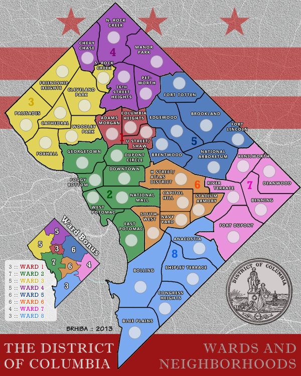
Mapmaker: brhiba
Number of Territories: 44
Number of Regions: 8
Special Features: none (aside from region bonuses)
What Makes This Map Worthy: *bias alert* There are currently no maps of Washington, D.C. – one of the greatest, most powerful cities of all time. This map fills that void, at least a little.
To Do
There’s a lot of explanation of my method/madness below. I tried to anticipate potential feedback as much as possible. Suffice to say, here’s what’s next:
Immediate: Figure out gameplay; Finalize bonuses; Determine if borders need to be adjusted
Soon: Improve legibility; Tweak design; Post small map (600x480)
Eventually: Code XML once gameplay and borders are finalized
Map Images
Large map (600x750):
- Click image to enlarge.
Large map with armies:
- Click image to enlarge.
Gameplay
Borders
It’s not immediately clear if this map is playable. I need help figuring out if all the territories-bordering-territories makes sense. Are regions easy enough to capture and difficult enough to hold (or vice versa)?
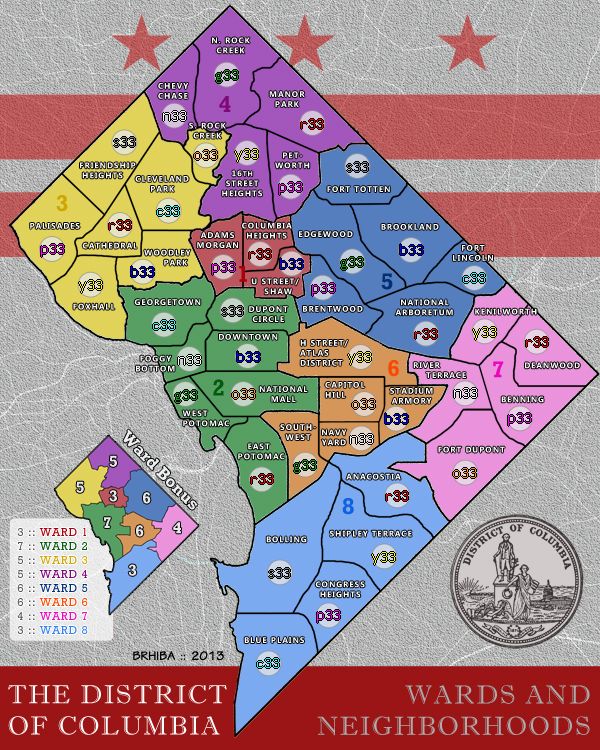
The primary borders (i.e. regions: Wards 1-8) are entirely faithful to the actual DC ward boundaries. This was my initial design requisite for the map. Even though they’re a little funky, the goal is that any subsequent revisions leave these major borders intact.
The minor borders (i.e. territories: the neighborhoods) are a little more flexible. Most of the neighborhoods are approximated; usually, they’re just the most recognizable in the immediate area (e.g. “Adams Morgan” on the map is in reality Adams Morgan, Mount Pleasant, and part of Woodley Park combined) and some of them would normally overlap ward boundaries (e.g. “Chevy Chase” in reality sits across Ward 3 and 4).
Bonuses
Also, need some feedback on the bonuses. I ran both the excel bonus calculator and the starting drop spreadsheet, and used a little intuition – but these are definitely draft numbers. As far as other special bonuses, the intention is to keep it basic – see below – but would be open to suggestions, such as a “city unity” award for holding wards on opposite sides, or something.
Etc.
Lastly, because there are lots of small territories in a condensed area, the text is a little hard to read, especially on the small version – working on it. Likewise, I’m playing with different ways to include the Ward numbers/titles in the background.
Design and Distinction *TL;DR alert*
Why this map?
Being relatively new to CC, I was immediately intrigued by the variety of maps – very cool for us history buffs and geo-politics mavens. But as a proud DC native, I was surprised to find no maps of America’s capital city. So, I made one.{1}
Primary Features *soapbox alert*
This map focuses on the wards and neighborhoods across the 10-mile diameter of the nation’s capital, which keeps it clean and simple.
Washington, D.C. – aka The District – is a fascinating city. Most people know only what they’ve seen on school trips or lobbying visits, but true Washingtonians know it’s much more than that. It has a diverse population and a wide range of terrific neighborhoods. That’s why this is titled District of Columbia rather than Washington, D.C. – I want to leave the latter name for the “familiar” version of the city (which I plan to create next, if I make it through this one alive).{2}
That’s also why there aren’t any major DC landmarks. Instead, the layout puts neighborhoods at the forefront and the design relies on DC branding: the flag and the city seal. Also considering adding a watermark of the city motto: “Justitia Omnibus” – Justice for All …(although it’s hard to know if that’s in line with the game’s guiding principles, or directly contrary…)
I also made the design decision to eliminate the Potomac River, since the Wards technically have jurisdiction and their boundaries encompass it. This is chiefly intended as a map of basic territories; water, bridges, impassables, etc. could be featured on another version of DC.{3} In essence, this map is “inherently unique" in location and theme, but not in gameplay - by intention.
As a final design note – an easter egg of sorts: the white lines behind the textured background, which give it a marbled, stone-y feel, are actually an accurate map of the roads that connect to DC from the surrounding areas in VA and MD.
{1} There seems to be a lot of discussion on these pages about “too many maps” – but I say: the more, the merrier. Aren’t we all here because we’re bored of the routine? We want options!
{2} *hopes and dreams alert* The “tourist” version would feature the Capitol, White House, Smithsonian, memorials and monuments, etc. and maybe the Metro as an overlay. That map would focus on the central downtown area including recognizable sights, rather than the entire city boundary. ... And, later – much later – I’m thinking about the burning of Washington during the War of 1812.
{3} Or maybe not...?
Antecedents
My enthusiasm impelled me to go ahead blindly and make this map with no regard to CC history. A subsequent search of the forum archive finds a few threads about a DC map. Maybe those folks want to chime in as well. Looking now at the past ideas, it seems this map does justice to the various options that have been offered so far:
- Washington, D.C. Peter Gibbons et. al
- Washington D.C. (Abandon) Unit_2 et. al
- Washington, D.C. Map atr1989 et. al
P.S.
I like the clean, “serious” maps. I hope my design and map title reflects that. BUT – we could add a nickname, maybe… SO, “War of the Wards” – catchy, or too cheesy?
That's all, for now...