first of all the text has already been higlighted as an issue, secondly there is 4 different texts on the map so please be more specific and lastly please try to say what is actually wrong with something rather than it is just balls. Is it too small, to intricate, are the letters to close together, is the initial type face a poor choice etc....ParadiceCity9 wrote:cant read the font for balls
Formerly the Map Ideas Thread, now CLOSED
Moderator: Cartographers
Forum rules
Please read the Community Guidelines before posting.
Please read the Community Guidelines before posting.
-
pepperonibread

- Posts: 954
- Joined: Sun Jan 28, 2007 4:33 pm
- Location: The Former Confederacy

-
DiM

- Posts: 10415
- Joined: Wed Feb 14, 2007 6:20 pm
- Gender: Male
- Location: making maps for scooby snacks
Bodmanbod wrote: so.... hhmmm are the continents too colourful?
1. find a theme or if it already has one then tell us what it is.
2. you're aiming for the old map look. something i did on my AoM map. i love it because it's really nice to look and see an actual map not just a pretty image that's supposed to be a map. BUT your colours are way too bright. they form a huge contrast with the old paper you have as a background. try some washed colors like the map is old.
3. although the paper image is ok it originally has some waves and a compass drawn on it. the problem is that in some places those waves intersect with text and make it less visible.
4. also if i'm not mistaking you drew the continents over existing ones. if that's the case and the image you used is already the image of a map then better check for copyright.
5. if the image is copyrighted then make your own old paper like this: take a sheet of A4 paper. crumple it in your hands until you form a ball. do this several times or just once depending on what you need. after the paper is crumpled, make some coffee and spill it on the paper to get some stains. as many as you need. then put the paper in the oven for a few minutes until it turns a little yellow in the center and brownish around the edges and you got yourself a nice looking old paper.
“In the beginning God said, the four-dimensional divergence of an antisymmetric, second rank tensor equals zero, and there was light, and it was good. And on the seventh day he rested.”- Michio Kaku

-
magneticgoop

- Posts: 851
- Joined: Fri Jun 01, 2007 9:03 pm
- Location: Screaming at the TV as Norv Turner turns the chargers into the worst team in the NFL =(
already been done http://www.conquerclub.com/forum/viewto ... sc&start=0

No, that's Alexanders Empire, not the Greek Empire.
The Greek Empire included areas around the Black Sea and all around the Mediterrean, including Southern Italy and some of Sciliy, all of Greece etc. etc.
The Greek Empire included areas around the Black Sea and all around the Mediterrean, including Southern Italy and some of Sciliy, all of Greece etc. etc.
KraphtOne wrote:when you sign up a new account one of the check boxes should be "do you want to foe colton24 (it is highly recommended) "
-
magneticgoop
- Posts: 851
- Joined: Fri Jun 01, 2007 9:03 pm
- Location: Screaming at the TV as Norv Turner turns the chargers into the worst team in the NFL =(


-
gimil

- Posts: 8599
- Joined: Sat Mar 03, 2007 12:42 pm
- Gender: Male
- Location: United Kingdom (Scotland)
it looks rather good but theres nothnig exciting about it i feel somethnigs missing.
1.try and design a better set of legends
2.Some contient names are overlappign the sea
3.requires a title and a space to fit it
4. i dont see the need to change the colors if army circles are introduced
anythngi else i see ahs been suggested.
overall the graphics look good it just needs that extra pop, somethnig eye catching. It just not doing anything special at the moment
-
magneticgoop
- Posts: 851
- Joined: Fri Jun 01, 2007 9:03 pm
- Location: Screaming at the TV as Norv Turner turns the chargers into the worst team in the NFL =(
-
magneticgoop
- Posts: 851
- Joined: Fri Jun 01, 2007 9:03 pm
- Location: Screaming at the TV as Norv Turner turns the chargers into the worst team in the NFL =(
Update
ok still working on it but this is the general idea. i know it is messy but i am working on it and wanted to get the general layout

Fool me once, strike one. Fool me twice, strike...three.
-
magneticgoop
- Posts: 851
- Joined: Fri Jun 01, 2007 9:03 pm
- Location: Screaming at the TV as Norv Turner turns the chargers into the worst team in the NFL =(
-
dominationnation
- Posts: 4234
- Joined: Sat Jan 13, 2007 10:20 am
If it is alreay on a web page then put the url into Img brackets like such:
If it is on your computer upload it on http://www.photobucket.com and then do the same thing. If you do it on photobucket they will give you a special URL underneath the pic once its in your album
Code: Select all
[img]Url of pic[/img]-
magneticgoop
- Posts: 851
- Joined: Fri Jun 01, 2007 9:03 pm
- Location: Screaming at the TV as Norv Turner turns the chargers into the worst team in the NFL =(

-
Fortworthian
- Posts: 34
- Joined: Tue Apr 10, 2007 7:38 pm
- Location: Oklahoma, USA
Amusement Park Map
Amusement Park Map
I think an amusement park map would be cool if someone could think one up... have like the water park area, the little kids area, Roller Coasters, games, resterants, Gate/gift shop, Ferris wheel, picnic area...
I think an amusement park map would be cool if someone could think one up... have like the water park area, the little kids area, Roller Coasters, games, resterants, Gate/gift shop, Ferris wheel, picnic area...


Re: Amusement Park Map
There are loads of maps hereFortworthian wrote:Amusement Park Map
I think an amusement park map would be cool if someone could think one up... have like the water park area, the little kids area, Roller Coasters, games, resterants, Gate/gift shop, Ferris wheel, picnic area...
http://www.themeparkjunkies.co.uk/index ... t=parkmaps
I'd be quite interested in this but I'm currently looking at a London Tourist Map and that is enough for me at the moment.

here's the thing...
The problem is that Lots of empires, Civilizations, and Wars revolved around the Mediterranean and Maps will get redundant... and there will be little interest... UNLESS you add different Gameplay mechanics... add something to make your map UNIQUE... wether it be with 1 way borders, ranged attacks, bonus options whatever...... but it needs to be seperate from the rest
-
dominationnation
- Posts: 4234
- Joined: Sat Jan 13, 2007 10:20 am
CC RACERS

It is sort of like circus maximus except for the fact that it is not as limited. Everything will be neutral except for the first few spots. There will also have to more lanes in case of 6 player games. The first few spaces will you cant attack to the side only foward and back but then its like a normal map except with the last spaces as objectives.
WHY: Because circus mazimus wouldnt have been much better if it wasnt as limited.

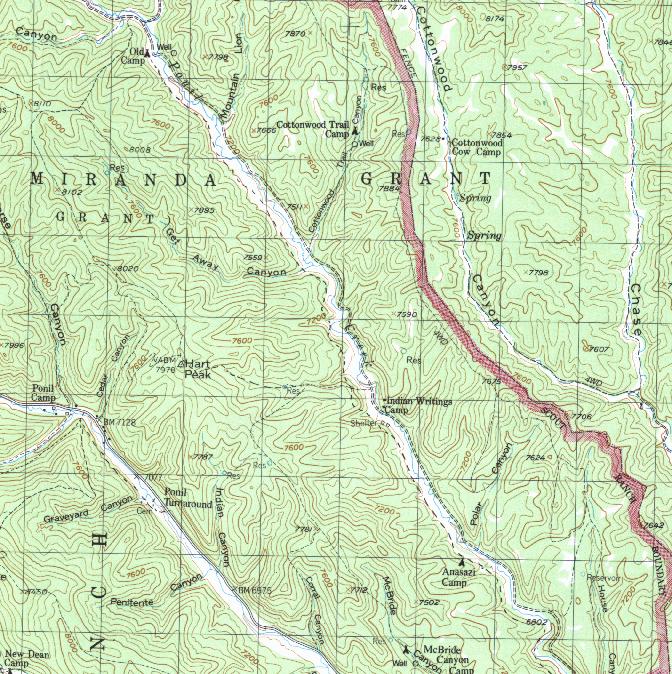
New map idea - Philmont map
Philmont is a 137,000 acre ranch owned by the Boy Scouts of America. It is the world's largest youth camp, as 22,000 scouts, scouters, explorers, and venturers, and scouter families from all over the world come for mountain backpacking treks each summer. I was thinking that it might be interesting to have a philmont risk map (an old overall map divided into 13 sections can be found here), where instead of having adjacent territories, the territiories would be the camps and the attacking routes would be along trails or roads that go directly from one camp to another. In addition to regional bonuses, there could be extra features regarding peaks, staffed camps, etc.
It may also be considered that instead of each camp being adjacent only to camps with a direct trail or road, camps could be adjacent to theses camps where another camp must be passed through to reach. Perhaps this would apply to staff camps only. For example, with these feature Anasazi (in Ponil region) could be able to attack Indian Writings, Cottonwood, Ponil, Old Camp, and McBride Canyon instead of just Indian Writings.
Base camp would be "adjacent" to all turnarounds.
The map would be decorated with photographs taken at the actual sites of each camp, and of course the trails would have to be cleaned up a little to make it easier to see.
What do you think? Give me some feedback. I will only have internet access every few days, but I will check but whenever I can.
-
thegeneralpublic
- Posts: 126
- Joined: Fri Mar 09, 2007 9:49 pm
- Location: In front of my computer screen.
- Contact:
I was told to post this idea up here, so I will...
INDIAN OCEAN
I thought it would be kind of cool to have a map of the Indian Ocean, including eastern Africa, southern China, the East Indies, and the Indian Ocean territories. I did a rough sketch of a map. Here's a link:

My friend had an idea of having a circle of one-way attacking territories in the middle, like a whirlpool. I thought it was kind of cool.
I'd like to see this map because I think that, with my friend's idea, it would give the map a unique edge that would be worth pursuing.