Conquer Club

Golfe Du St. Laurent

Care to peruse completed maps? Take a stroll through the Atlas.

Moderator: Cartographers

Forum rules
Please read the Community Guidelines before posting.

Golfe Du St. Laurent

Postby Tisha on Mon Mar 07, 2011 1:25 am

Last edited by Tisha on Mon Aug 22, 2011 12:13 pm, edited 10 times in total.
User avatar
Major Tisha
 
Posts: 1065
Joined: Sat Dec 23, 2006 12:41 am

Re: Golfe Du St. Laurent

Postby natty dread on Mon Mar 07, 2011 2:08 am

This should be in Final Forge...
Image
User avatar
Sergeant 1st Class natty dread
 
Posts: 12877
Joined: Fri Feb 08, 2008 8:58 pm
Location: just plain fucked

Re: Golfe Du St. Laurent

Postby Victor Sullivan on Mon Mar 07, 2011 2:14 am

natty_dread wrote:This should be in Final Forge...

Probably posted it here so it could be moved.
User avatar
Corporal Victor Sullivan
 
Posts: 6010
Joined: Mon Feb 08, 2010 8:17 pm
Location: Columbus, OH

Re: Golfe Du St. Laurent

Postby thenobodies80 on Mon Mar 07, 2011 3:47 am

Victor Sullivan wrote:
natty_dread wrote:This should be in Final Forge...

Probably posted it here so it could be moved.


Correct. ;)

[Moved]
User avatar
Sergeant 1st Class thenobodies80
 
Posts: 5400
Joined: Wed Sep 05, 2007 4:30 am
Location: Milan

Re: Golfe Du St. Laurent

Postby Tisha on Mon Mar 07, 2011 10:24 am

can't make a new post in Final Forge... how it should be.

so what don't you like about it?
User avatar
Major Tisha
 
Posts: 1065
Joined: Sat Dec 23, 2006 12:41 am

Re: Golfe Du St. Laurent

Postby Riskismy on Mon Mar 07, 2011 1:52 pm

What's not to like? Only thing I can think of is that the army-thingies should be there, right?

oh! Well perhaps I'd go with a 'colder' colour scheme to show the nature of the climate.
oh shit. I'm turning into natty! ;)
Image
Lieutenant Riskismy
 
Posts: 391
Joined: Thu Jun 01, 2006 8:21 pm
Location: Copenhagen

Re: Golfe Du St. Laurent

Postby natty dread on Mon Mar 07, 2011 2:03 pm

Ok, everything looks pretty good here. Congrats for winning Tisha! =D>

I think the colour scheme is ok, except for Duplessis: it looks bad with the colourblind filters - it's hard to tell where the islands & Gaspesie belong:

Click image to enlarge.
image


I'd suggest making the colour of Duplessis lighter. Alternatively, Swap the colours of Nova Scotia & Duplessis.

Also, I'd suggest moving the territory labels of Bas St. Laurent, Anticosti, PEI on both maps and maybe Gaspesie on the small map, so that you can fit the troop numbers inside the land area.
Image
User avatar
Sergeant 1st Class natty dread
 
Posts: 12877
Joined: Fri Feb 08, 2008 8:58 pm
Location: just plain fucked

Re: Golfe Du St. Laurent

Postby Victor Sullivan on Mon Mar 07, 2011 3:09 pm

natty_dread wrote: Alternatively, Swap the colours of Nova Scotia & Duplessis.

This.

Wow, I am drawing blanks, this looks really nice...
User avatar
Corporal Victor Sullivan
 
Posts: 6010
Joined: Mon Feb 08, 2010 8:17 pm
Location: Columbus, OH

Re: Golfe Du St. Laurent

Postby natty dread on Mon Mar 07, 2011 4:12 pm

On second thought... the best solution could be this:

Duplessis colour -> New Brunswick
New Brunswick colour -> Nova Scotia
Nova Scotia colour -> Duplessis

This way, no similar colours (as seen by colourblind) would be adjacent.
Image
User avatar
Sergeant 1st Class natty dread
 
Posts: 12877
Joined: Fri Feb 08, 2008 8:58 pm
Location: just plain fucked

Re: Golfe Du St. Laurent

Postby isaiah40 on Mon Mar 07, 2011 8:42 pm

A little late, but here's a big round of applause to you! =D> =D> =D> =D> =D> =D> =D> =D> =D> =D> =D> =D> =D> =D> =D> =D> Congratulations!
Lieutenant isaiah40
 
Posts: 3990
Joined: Mon Aug 27, 2007 7:14 pm

Re: Golfe Du St. Laurent

Postby Bruceswar on Mon Mar 07, 2011 8:53 pm

Looking forward to playing this one!
Highest Rank: 26 Highest Score: 3480
Image
User avatar
Corporal Bruceswar
 
Posts: 9713
Joined: Sun Dec 23, 2007 12:36 am
Location: Cow Pastures

Re: Golfe Du St. Laurent

Postby Tisha on Tue Mar 08, 2011 7:30 pm

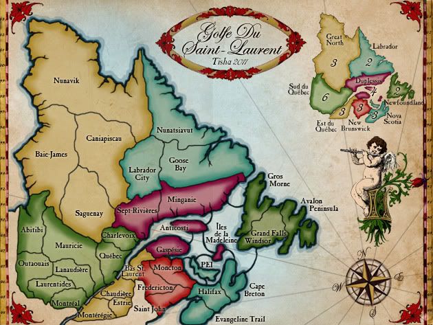
colors better?

Click image to enlarge.
image
User avatar
Major Tisha
 
Posts: 1065
Joined: Sat Dec 23, 2006 12:41 am

Re: Golfe Du St. Laurent

Postby natty dread on Wed Mar 09, 2011 3:14 am

Yes, they look better.

Can we see these with 888:s?
Image
User avatar
Sergeant 1st Class natty dread
 
Posts: 12877
Joined: Fri Feb 08, 2008 8:58 pm
Location: just plain fucked

Re: Golfe Du St. Laurent

Postby iancanton on Thu Mar 10, 2011 3:34 pm

if u need to alter the shape of some of the regions of sud-du-québec to make troops counts fit, while retaining the same gameplay, then feel free to do so. the borders in that bonus zone came about from a scribbled diagram that i made to show the connections, but the somewhat accidental shapes of each region in that diagram were largely retained till now. this is how the borders look on a real political map of québec.

http://www.gouv.qc.ca/portail/quebec/pg ... x/?lang=en

try to retain the characteristic long straight edge of minganie. on the government map, the dotted area close to the border is disputed land that is administered by newfoundland & labrador, but claimed by québec.

ian. :)
Image
User avatar
Brigadier iancanton
Foundry Foreman
Foundry Foreman
 
Posts: 2431
Joined: Fri Jun 01, 2007 5:40 am
Location: europe

Re: Golfe Du St. Laurent

Postby Orange-Idaho-Dog on Fri Mar 11, 2011 2:24 am

Great map Tisha. In my opinion, far better than the original images.

If you would like the original XML file, to save a bit of time, PM me and I will send it to you.

Congratz again 8-)


*Edit*

Some name fixes, assuming the original map was correct with the geographical names.

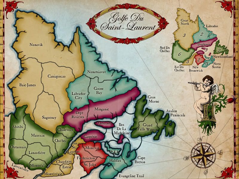
Chalevoix -> Charlevoix
Dept-Rivieres -> Sept-Rivieres
Avalon Penincula - > Avalon Peninsula
Grand Falls Winsor -> Grand Falls Windsor (GF-Windsor, on original map)
Image
Looking for a clan? Click here to send me a PM and find out how to join The Underworld! *Selective Recruitment*
User avatar
Sergeant 1st Class Orange-Idaho-Dog
 
Posts: 555
Joined: Sun Jan 14, 2007 12:41 pm
Location: South Carolina

Re: Golfe Du St. Laurent

Postby ender516 on Fri Mar 11, 2011 3:53 pm

Also Lanaudiere should have an accent grave (down to the right) not an accent aigu (up to the right). (Sorry, no international keyboard here at work.)
User avatar
Sergeant 1st Class ender516
 
Posts: 4455
Joined: Wed Dec 17, 2008 6:07 pm
Location: Waterloo, Ontario

Re: Golfe Du St. Laurent

Postby isaiah40 on Fri Mar 11, 2011 4:47 pm

ender516 wrote:Also Lanaudiere should have an accent grave (down to the right) not an accent aigu (up to the right). (Sorry, no international keyboard here at work.)


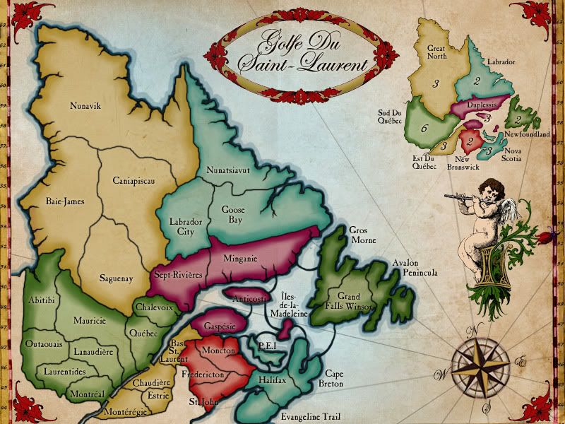
True like this:
Lanaudière and here are the other corrections:

Îles-de-la-Madeleine
Sept-Rivières
Chaudière

Just copy these and paste them onto your map! :D
Lieutenant isaiah40
 
Posts: 3990
Joined: Mon Aug 27, 2007 7:14 pm

Re: Golfe Du St. Laurent

Postby Tisha on Thu Mar 17, 2011 1:57 am

iancanton wrote:if u need to alter the shape of some of the regions of sud-du-québec to make troops counts fit, while retaining the same gameplay, then feel free to do so. the borders in that bonus zone came about from a scribbled diagram that i made to show the connections, but the somewhat accidental shapes of each region in that diagram were largely retained till now. this is how the borders look on a real political map of québec.

http://www.gouv.qc.ca/portail/quebec/pg ... x/?lang=en

try to retain the characteristic long straight edge of minganie. on the government map, the dotted area close to the border is disputed land that is administered by newfoundland & labrador, but claimed by québec.

ian. :)

can you explain what you mean better? I'm sorry my brain is acting broke, and I can't understand no matter how many times I read it.. :oops:
User avatar
Major Tisha
 
Posts: 1065
Joined: Sat Dec 23, 2006 12:41 am

Re: Golfe Du St. Laurent

Postby ender516 on Thu Mar 17, 2011 11:44 am

If you are having trouble with the second part, I believe he means that most of the border between Goose Bay and Minganie should be a straight line (or at least a line of latitude, so it might curve, depending on the projection of the map). The small upward tooth at the west end looks okay to me, and at the east end there should be a sharp turn due south.

As far as the first part goes, I guess he is saying that, for example, you could enlarge Laurentides or Montréal at the expense of Outaouais and Lanaudière, provided you do not separate those two, even though on the Quebec government map, they do not border each other.
User avatar
Sergeant 1st Class ender516
 
Posts: 4455
Joined: Wed Dec 17, 2008 6:07 pm
Location: Waterloo, Ontario

Re: Golfe Du St. Laurent

Postby iancanton on Wed Mar 23, 2011 4:03 pm

ender516 wrote:If you are having trouble with the second part, I believe he means that most of the border between Goose Bay and Minganie should be a straight line (or at least a line of latitude, so it might curve, depending on the projection of the map).

correct!

ender516 wrote:As far as the first part goes, I guess he is saying that, for example, you could enlarge Laurentides or Montréal at the expense of Outaouais and Lanaudière, provided you do not separate those two, even though on the Quebec government map, they do not border each other.

right again! i didn't notice that montréal doesn't border lanaudière on the government map. it does on the bonjourquebec.com tourist map (see inset on bottom right).

http://www.bonjourquebec.com/qc-en/regions0.html

ian. :)
Image
User avatar
Brigadier iancanton
Foundry Foreman
Foundry Foreman
 
Posts: 2431
Joined: Fri Jun 01, 2007 5:40 am
Location: europe

Re: Golfe Du St. Laurent

Postby notyou2 on Mon Mar 28, 2011 10:30 am

Great map Tish.

I hope to be playing it soon.

I would love to see a Plains of Abraham map where the English met the French in Quebec. It was avery historic battle for North America.
Image
User avatar
Captain notyou2
 
Posts: 6447
Joined: Thu Jan 15, 2009 10:09 am
Location: In the here and now

Re: Golfe Du St. Laurent

Postby Tisha on Wed Mar 30, 2011 10:46 am

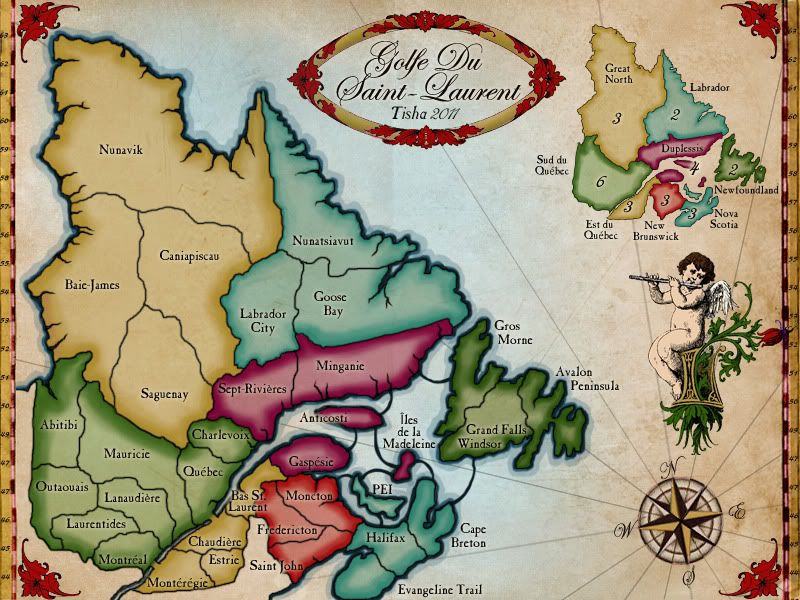
anything else?

green looks nice now.

Click image to enlarge.
image
User avatar
Major Tisha
 
Posts: 1065
Joined: Sat Dec 23, 2006 12:41 am

Re: Golfe Du St. Laurent

Postby natty dread on Wed Mar 30, 2011 10:50 am

Can we see the map with 888:s on it?
Image
User avatar
Sergeant 1st Class natty dread
 
Posts: 12877
Joined: Fri Feb 08, 2008 8:58 pm
Location: just plain fucked

Re: Golfe Du St. Laurent

Postby Unit_2 on Mon Apr 04, 2011 5:53 am

I'm sure there are other colors you can use besides yellow and green twice. Add Orange to a yellow and Purple, swap Duplessis with Newfoundland and give Newfoundland purple. Other colors work too, but two of the same colors makes no sense to me when there are hundreds of them. Colorblindness is a problem, but with a wide enough color scheme, there won't be any problems.

U2.
Image
User avatar
Cook Unit_2
 
Posts: 1834
Joined: Sun Jan 14, 2007 12:59 pm
Location: Pennsylvania, U.S.A, North America, Earth, Milky Way, Universe.

Re: Golfe Du St. Laurent

Postby natty dread on Mon Apr 04, 2011 7:28 am

Unit_2 wrote:I'm sure there are other colors you can use besides yellow and green twice. Add Orange to a yellow and Purple, swap Duplessis with Newfoundland and give Newfoundland purple. Other colors work too, but two of the same colors makes no sense to me when there are hundreds of them. Colorblindness is a problem, but with a wide enough color scheme, there won't be any problems.


I think the current colours are ok, since there's a minimap it's not that important to have unique colours for each...
Image
User avatar
Sergeant 1st Class natty dread
 
Posts: 12877
Joined: Fri Feb 08, 2008 8:58 pm
Location: just plain fucked

Next

Return to The Atlas

Who is online

Users browsing this forum: No registered users