Conquer Club

Iceland [Quenched]

Care to peruse completed maps? Take a stroll through the Atlas.

Moderator: Cartographers

Forum rules
Please read the Community Guidelines before posting.

Re: Iceland [I, Gp, Gr, FF] (Big & Small Maps Pg.1 & 18)

Postby Ruben Cassar on Sat May 10, 2008 4:13 am

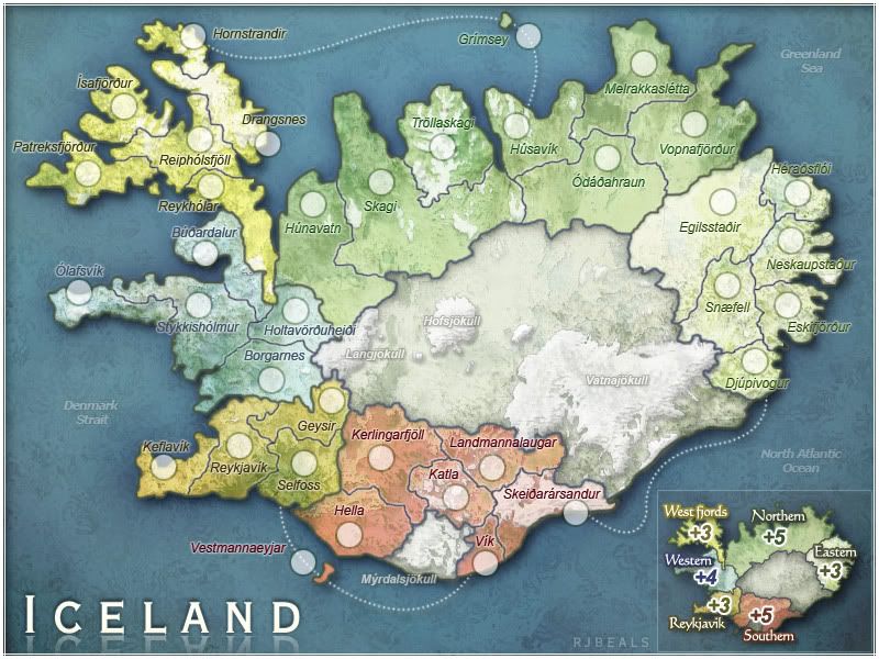
GummiT wrote:You are right about the Denmark straight, Greenland is a Danish colony. However, he put Norwegian sea as Greenland sea judging by the map you put up. And yes we refer to these bodies of water diffrently, at least when i sailed these seas as a fisherman. The norht Atlantic is still the north atlantic, that can't be to the East of the island.

And here is how we call our coastal waters: http://www.franksingleton.clara.net/ice ... areas.html


Interesting stuff. I did a search using Italian and French to see if this was a "cultural" thing and some of them used the Icelandic version of the names while others used the Anglo-American version. So there is a bit of confusion on this matter.

Since the map's ocean and sea names are in English I suggest we stick with RJ's version.
ImageImageImageImageImage
User avatar
Colonel Ruben Cassar
 
Posts: 2160
Joined: Thu Nov 16, 2006 6:04 am
Location: Civitas Invicta, Melita, Evropa

Re: Iceland [I, Gp, Gr, FF] (Big & Small Maps Pg.1 & 18)

Postby The Viking on Sat May 10, 2008 7:26 am

The Denmark Strait is a part of the Greenland Sea, which encompasses the area between Greenland and Iceland as well as the part north of Iceland.
The Greenland Sea, as far as I know, is rarely considered part of the North Atlantic Ocean.
I'd say the Denmark Strait does not stretch to Reykjanes, that specific area would rather be Faxaflói(Faxa-bay, the area between Keflavík and Ólafsvík) or just the North Atlantic Ocean.
If the 'Denmark Strait' text were moved to the upper-left corner that would be more correct, but does it really matter?

E.s. GummiT, langar þig ekki að keppa með íslenska liðinu í 2008 World Cup? :D sjá viewtopic.php?f=90&t=50260&st=0&sk=t&sd=a
User avatar
Corporal 1st Class The Viking
 
Posts: 148
Joined: Fri Feb 15, 2008 10:58 am

Re: Iceland [I, Gp, Gr, FF] (Big & Small Maps Pg.1 & 18)

Postby Unit_2 on Sat May 10, 2008 2:43 pm

In the legand the south island is not colored red , you might want to change it.
Image
User avatar
Corporal Unit_2
 
Posts: 1834
Joined: Sun Jan 14, 2007 12:59 pm
Location: Pennsylvania, U.S.A, North America, Earth, Milky Way, Universe.

Re: Iceland [I, Gp, Gr, FF] (Big & Small Maps Pg.1 & 18)

Postby RjBeals on Mon May 12, 2008 7:57 am

Click image to enlarge.
image


Image

ZeakCytho wrote:It's not really that big a deal if you keep them where they are, but I think it would be more clear if the attack lines weren't blocked. Since Gimsey is a pretty easy fix, I'd move it. Vestmannaeyjar isn't as simple, and the best solution may be as you have it right now.


I just don't think that having the islands circles on top of the attack lines will cause confustion, or looks bad. I think it's actually less confusing to have them on top of the attack lines. I would prefer to keep them as is - unless others also speak up.


Ruben Cassar wrote:Since the map's ocean and sea names are in English I suggest we stick with RJ's version.


The searches I used were English, and I simply used those. I like Ruben's suggestion ;)

unit_2 wrote:In the legand the south island is not colored red , you might want to change it.

Hmm.. Vestmannaeyjar (small southern island) is red on the legends. I just think it's so small that it's hard to see. I don't think anyone will have to refer to the legend though to see which region the islands belong too.

Still working on xml - it's convoluted so it may take a while.
Image
User avatar
Private RjBeals
 
Posts: 2506
Joined: Mon Nov 20, 2006 5:17 pm
Location: South Carolina, USA

Re: Iceland [I, Gp, Gr, FF] (Big & Small Maps Pg.1 & 18)

Postby RjBeals on Mon May 12, 2008 1:52 pm

Question?
In Northern Region,
Should Skagi border Husavik?

Right now it is bordering - but not by much. Should I keep it as is, move the Husavik border up so it doesn't border Skagi, or move the Husavik border down to it's a more obvious connection?
Image
User avatar
Private RjBeals
 
Posts: 2506
Joined: Mon Nov 20, 2006 5:17 pm
Location: South Carolina, USA

Re: Iceland [I, Gp, Gr, FF] (Big & Small Maps Pg.1 & 18)

Postby AndyDufresne on Mon May 12, 2008 2:05 pm

I believe you should keep the connection, to keep the area from being an exclusive one territory march. You could make the connection more obvious, perhaps a little.


--Andy
User avatar
Corporal 1st Class AndyDufresne
 
Posts: 24919
Joined: Fri Mar 03, 2006 8:22 pm
Location: A Banana Palm in Zihuatanejo

Re: Iceland [I, Gp, Gr, FF] (Big & Small Maps Pg.1 & 18)

Postby ZeakCytho on Mon May 12, 2008 2:08 pm

I think the connection is visible enough as is, but if you feel like making it more noticeable, then by all means do so. I'd definitely keep the border, though, since I think the region has nice gameplay as is.
User avatar
Captain ZeakCytho
 
Posts: 1251
Joined: Wed Sep 12, 2007 4:36 pm

Re: Iceland [I, Gp, Gr, FF] (Big & Small Maps Pg.1 & 18)

Postby cicero on Mon May 12, 2008 3:23 pm

RjBeals

Reading in another forum and saw the map image in your sig and it caught my eye.
I really like the graphics and, like you, I tend to be drawn to classic gameplay maps (I like Scotland).

Reading the first post I found ...
RjBeals wrote:30 post-glacial volcanoes have erupted in the past two centuries, and natural hot water supplies much of the population with cheap, pollution-free heating.

I like the idea that volcanoes are pollution-free :)
[Though of course I understand your intention.]

Looking forward to playing your map.

Cicero
User avatar
Sergeant cicero
 
Posts: 1358
Joined: Wed Mar 07, 2007 1:51 pm
Location: with the infected neutrals ... handing out maps to help them find their way to CC

Re: Iceland [I, Gp, Gr, FF] (Big & Small Maps Pg.1 & 18)

Postby The Viking on Mon May 12, 2008 5:43 pm

Maybe move the Skagi-Húsavík border up? Or will that make it look funny?
User avatar
Corporal 1st Class The Viking
 
Posts: 148
Joined: Fri Feb 15, 2008 10:58 am

Re: Iceland [I, Gp, Gr, FF] (Big & Small Maps Pg.1 & 18)

Postby RjBeals on Tue May 13, 2008 8:29 am

Calling all coders...

Does anyone want to do the xml for this map? I'm just not into it, and It will take me a long time before I do it. I started it, and my plan was to do it in normal english characters. Then find & replace each word with the Icelandic characters coded from this link: http://en.wikipedia.org/wiki/List_of_XM ... references

It's going to be a bitch. And look a mess. So even though it's a straightforward map, it's going to be confusing.
Your name will appear on the map beside mine.

I think I would rather revive my charleston map from the dead ;)
Image
User avatar
Private RjBeals
 
Posts: 2506
Joined: Mon Nov 20, 2006 5:17 pm
Location: South Carolina, USA

Re: Iceland [I, Gp, Gr, FF] (Big & Small Maps Pg.1 & 18)

Postby cairnswk on Tue May 13, 2008 8:40 am

RjBeals wrote:Calling all coders...

Does anyone want to do the xml for this map? I'm just not into it, and It will take me a long time before I do it. I started it, and my plan was to do it in normal english characters. Then find & replace each word with the Icelandic characters coded from this link: http://en.wikipedia.org/wiki/List_of_XM ... references

It's going to be a bitch. And look a mess. So even though it's a straightforward map, it's going to be confusing.
Your name will appear on the map beside mine.

I think I would rather revive my charleston map from the dead ;)


RJ...I'll have a go at it for you. Give me a link to anything you've got done, and I'll polish it off in a couple of days. :)
Image
* Pearl Harbour * Waterloo * Forbidden City * Jamaica * Pot Mosbi
User avatar
Private cairnswk
 
Posts: 11510
Joined: Sat Feb 03, 2007 8:32 pm
Location: Australia

Re: Iceland [I, Gp, Gr, FF] (Anyone up for XML? pg-19)

Postby RjBeals on Tue May 13, 2008 8:45 am

Really Carins?

Be my guest. Here's the code I've done so far. Not much, but at least a start

Code: Select all
<?xml version="1.0"?>
<map>
<title>Iceland</title>
<smallwidth>600</smallwidth>
<smallheight>450</smallheight>
<largewidth>800</largewidth>
<largeheight>600</largeheight>
<filetype>jpg</filetype>


<continent>
<name>Westfjords</name>
<bonus>3</bonus>
<components>
<territory>Hornstrandir</territory>
<territory>isafjordur</territory>
<territory>Drangsnes</territory>
<territory>Patreksfjordur</territory>
<territory>Reipholsfjoll</territory>
<territory>Reykholar</territory>
</components>
</continent>


<continent>
<name>Northern</name>
<bonus>5</bonus>
<components>
<territory>Hunavatn</territory>
<territory>Skagi</territory>
<territory>Trollaskagi</territory>
<territory>Grimsey</territory>
<territory>Husavik</territory>
<territory>Odadahraun</territory>
<territory>Melrakkasletta</territory>
<territory>Vopnafjordur</territory>
</components>
</continent>


<continent>
<name>Eastern</name>
<bonus>3</bonus>
<components>
<territory>Egilsstadir</territory>
<territory>Heraosfloi</territory>
<territory>Snaefell</territory>
<territory>Neskaupstaour</territory>
<territory>Eskifjordur</territory>
<territory>Djupivogur</territory>
</components>
</continent>


<continent>
<name>Southern</name>
<bonus>5</bonus>
<components>
<territory>Kerlingarfjoll</territory>
<territory>Hella</territory>
<territory>Katla</territory>
<territory>Landmannalaugar</territory>
<territory>Vik</territory>
<territory>Vestmannaeyjar</territory>
<territory>Skeidarsandur</territory>
</components>
</continent>


<continent>
<name>Reykjavik</name>
<bonus>3</bonus>
<components>
<territory>Reykjavik</territory>
<territory>Geysir</territory>
<territory>Selfoss</territory>
<territory>Keflavik</territory>
</components>
</continent>


<continent>
<name>Western</name>
<bonus>4</bonus>
<territory>Holtavorduheidi</territory>
<territory>Borgarnes</territory>
<territory>Stykkisholmur</territory>
<territory>Olafsvik</territory>
</components>
</continent>


<!— http://en.wikipedia.org/wiki/List_of_XML_and_HTML_character_entity_references à


<territory>
<name>isafjordur</name>
<borders>
<border>Reipholsfjoll</border>
</borders>
<coordinates>

</coordinates>
</territory>


<territory>
<name>Patreksfjordur</name>
<borders>
<border>Reipholsfjoll</border>
</borders>
<coordinates>
 
</coordinates>
</territory>


<territory>
<name>Reipholsfjoll</name>
<borders>
<border>Patreksfjordur</border>
<border>isafjordur</border>
<border>Drangsnes</border>
<border>Reykholar</border>
</borders>
<coordinates>

</coordinates>
</territory>


<territory>
<name>Drangsnes</name>
<borders>
<border>Hornstandir</border>
<border>Reipholsfjoll</border>
</borders>
<coordinates>
 
</coordinates>
</territory>


<territory>
<name>Hornstrandir</name>
<borders>
<border>Grimsey</border>
<border>Drangsnes</border>
</borders>
<coordinates>
 
</coordinates>
</territory>

<territory>
<name>Reykholar</name>
<borders>
<border>Reipholsfjoll</border>
<border>Budardalur</border>
<border>Hunavatn</border>
</borders>
<coordinates>
 
</coordinates>
</territory>
Image
User avatar
Private RjBeals
 
Posts: 2506
Joined: Mon Nov 20, 2006 5:17 pm
Location: South Carolina, USA

Re: Iceland [I, Gp, Gr, FF] (Anyone up for XML? pg-19)

Postby The Viking on Tue May 13, 2008 9:56 am

I guess it would be alot quicker for me to do it since I wouldn't have to check the map to see which names have icelandic characters.
I don't know anything about XML coding though, but I'm sure I could handle replacing, when the coding is done.
Wouldn't want my name on the map though.
User avatar
Corporal 1st Class The Viking
 
Posts: 148
Joined: Fri Feb 15, 2008 10:58 am

Re: Iceland [I, Gp, Gr, FF] (Anyone up for XML? pg-19)

Postby zimmah on Tue May 13, 2008 10:21 am

working on it, consider it done, coding is easy, it just takes some time to get all the coords perfect.

btw, the ó ú etc can not be printed so i just make them regular o and u and such
Click image to enlarge.
image
User avatar
Major zimmah
 
Posts: 1652
Joined: Fri Jun 01, 2007 12:43 pm
Location: VDLL

Re: Iceland [I, Gp, Gr, FF] (Anyone up for XML? pg-19)

Postby yeti_c on Tue May 13, 2008 10:55 am

Ó =
Code: Select all
&#x211;


Ú =
Code: Select all
&#x218;


C.
Image
Highest score : 2297
User avatar
Lieutenant yeti_c
 
Posts: 9624
Joined: Thu Jan 04, 2007 9:02 am

Re: Iceland [I, Gp, Gr, FF] (Anyone up for XML? pg-19)

Postby bryguy on Tue May 13, 2008 12:07 pm

id do the xml, 'cept i cant do unicode..... or the strange symbols above most of the letters
Corporal bryguy
 
Posts: 4381
Joined: Tue Aug 07, 2007 8:50 am
Location: Lost in a Jigsaw

Re: Iceland [I, Gp, Gr, FF] (Anyone up for XML? pg-19)

Postby zimmah on Tue May 13, 2008 12:47 pm

yeti_c wrote:Ó =
Code: Select all
&#x211;


Ú =
Code: Select all
&#x218;


C.


thx yeti, i'll see if i can do anything with that.

btw, the xml is halfway done now (i had to eat in the maintime so it took some longer)

and the coordinates are perfect i will post a picture when i'm done, along with the XML code off course
Click image to enlarge.
image
User avatar
Major zimmah
 
Posts: 1652
Joined: Fri Jun 01, 2007 12:43 pm
Location: VDLL

Re: Iceland [I, Gp, Gr, FF] (Anyone up for XML? pg-19)

Postby RjBeals on Tue May 13, 2008 12:54 pm

holy crap.
Image
User avatar
Private RjBeals
 
Posts: 2506
Joined: Mon Nov 20, 2006 5:17 pm
Location: South Carolina, USA

Re: Iceland [I, Gp, Gr, FF] (Anyone up for XML? pg-19)

Postby t-o-m on Tue May 13, 2008 1:36 pm

RjBeals wrote:holy crap.

what?
every1 volenteering!

i think they just want their name on the map! :P
User avatar
Major t-o-m
 
Posts: 2918
Joined: Sat Mar 22, 2008 2:22 pm

Re: Iceland [I, Gp, Gr, FF] (Anyone up for XML? pg-19)

Postby bryguy on Tue May 13, 2008 2:44 pm

t-o-m wrote:
RjBeals wrote:holy crap.

what?
every1 volenteering!

i think they just want their name on the map! :P


i know i do :mrgreen:

its such an awesome map!
Corporal bryguy
 
Posts: 4381
Joined: Tue Aug 07, 2007 8:50 am
Location: Lost in a Jigsaw

Re: Iceland [I, Gp, Gr, FF] (Anyone up for XML? pg-19)

Postby cairnswk on Tue May 13, 2008 2:58 pm

zimmah wrote:working on it, consider it done, coding is easy, it just takes some time to get all the coords perfect.

btw, the ó ú etc can not be printed so i just make them regular o and u and such


Kewl OK,,,i won't bother then.
Image
* Pearl Harbour * Waterloo * Forbidden City * Jamaica * Pot Mosbi
User avatar
Private cairnswk
 
Posts: 11510
Joined: Sat Feb 03, 2007 8:32 pm
Location: Australia

Re: Iceland [I, Gp, Gr, FF] (Anyone up for XML? pg-19)

Postby t-o-m on Tue May 13, 2008 3:17 pm

cairnswk wrote:Kewl OK,,,i won't bother then.

like you need your name on any more maps! ur name is on so many maps that we should just re-name this site:
CairnsWK Club
^CC for short!^
8-)
User avatar
Major t-o-m
 
Posts: 2918
Joined: Sat Mar 22, 2008 2:22 pm

Re: Iceland [I, Gp, Gr, FF] (Anyone up for XML? pg-19)

Postby zimmah on Tue May 13, 2008 3:39 pm

im done with everything except the continents.

here are pictures of the army placements, does anyone think the placement should be adjusted?

large map:

Click image to enlarge.
image


small map:

Image

i'm sorry for the colors, it's just saved as a JPG image and that fucks up the colors. it's no big deal anyways.
Click image to enlarge.
image
User avatar
Major zimmah
 
Posts: 1652
Joined: Fri Jun 01, 2007 12:43 pm
Location: VDLL

Re: Iceland [I, Gp, Gr, FF] (Anyone up for XML? pg-19)

Postby cairnswk on Tue May 13, 2008 3:45 pm

t-o-m wrote:
cairnswk wrote:Kewl OK,,,i won't bother then.

like you need your name on any more maps! ur name is on so many maps that we should just re-name this site:
CairnsWK Club
^CC for short!^
8-)

My name on another map i don't need. I was simply volunteering in good spirit. But Zimmah beat me to it. At least the xml is done now.
Image
* Pearl Harbour * Waterloo * Forbidden City * Jamaica * Pot Mosbi
User avatar
Private cairnswk
 
Posts: 11510
Joined: Sat Feb 03, 2007 8:32 pm
Location: Australia

Re: Iceland [I, Gp, Gr, FF] (Anyone up for XML? pg-19)

Postby RjBeals on Tue May 13, 2008 3:47 pm

Looks good to me zimmah. Where'd you come from anyway?
Image
User avatar
Private RjBeals
 
Posts: 2506
Joined: Mon Nov 20, 2006 5:17 pm
Location: South Carolina, USA

PreviousNext

Return to The Atlas

Who is online

Users browsing this forum: No registered users