owenshooter wrote:MrBenn wrote:owenshooter wrote:...they were willing to scrap the perfect inaccurate germany map, so why not scrap the inferior more accurate replacement...
Perfection is entirely subjective, and virtually unachievable.
Accuracy is something we can aim towards 
soooo, that is why
THE RHINE was removed? i mean, that isn't a major feature of germany's landscape at all, is it... the map is in no way better than the original, hard work does not equate good work. just bring back the original.
Again, here is the explanation as to why the Rhine was left out:
pepperonibread wrote:http://cheeseperi.free.fr/Jeopardy/culture/rhine.gifAs you can see from this image, the Rhine makes it's way first along the southwest border of Germany, a place where it would just add clutter to the map. It then does cut through Germany, in the light-red area of the revamped map (Rheinhessen). But it would serve no purpose there either, as it would be cutting straight through a continent. So I think it's fair to say that to add the Rhine to the map, however important a river it is, would be a useless addition - unless you want to change the map's basic gameplay.
And that's honestly the crux of the problem (this problem, and many other issues dealing with accuracy). I'll state right out that this map isn't an accurate portrayal of Germany. However, taking into account the fact that no gameplay could be changed whatsoever, I can certainly say that this map is much more accurate than the previous Germany 1.
Though granted, you could still say that without the Rhine this map seems now less accurate than the former map. But here's a quick list I came up with regarding inaccuracies in Germany 1:
1. The continent borders to a degree arbitrary, and do not seem to correspond with the borders of German states.
2. No umlauts are used.
3. In some cases, the original German names are used (Köln, Nürnberg, etc.), while elsewhere the Anglicized versions are displayed (Bavaria, Prussia, etc.).
4. No real river runs between the continents of "Rheinland" and "Hessen".
5. Hemeln on the map is merely a borough with a population of only 960.
6. Dresden is located in the state of Saxony, though on the map it is a part of the "Prussia" continent.
7. The territories of Bavaria, Hessen, Sachsen, and Niedersachsen are names of German states, not cities or small regions (this is akin to having, for example, a territory called "Ohio" within a continent also called Ohio).
8. No real river runs between the continents of ""Prussia" and "East Germany".
9. The territory Halberstadt is far displaced from the actual location of the city.
10. Augsburg is located in southern Bavaria, while on the map it is significantly more northern.
11. Bamberg is a town with population approx. 70,000, there are better areas that this territory could've been name for (Wurzburg).
12. I can't even find Donrath on Wikipedia; I think this was supposed to be the town of Lohmar (which is only a small area anyway).
I believe that most, if not all, of these problems were fixed in the Germany Revamp. Probably most important of these remedies was the changes to border shape. The current borders line up much better with German political divisions than in the old map.
Knowing this, I still hold that this revamp is significantly more accurate the the old map, especially after taking into account the restriction of gameplay. I will of course continue to field suggestions on how to increase the accuracy even more, however we have to keep in mind that not everything will be possible due to the necessity of keeping gameplay identical.
As for individual concerns about accuracy:
Seulessliathan wrote:Seulessliathan wrote:wasn´t there a river in the north of Münster? Rhein isn´t there exactly , but .... mountains? There aren´t any mountains around. Can you change this back to river please? (although the river is wrong, because there are only small rivers, and the Rhein is elsewhere, but mountains doesn´t exist there.
no response? mountains between Münster and Osnabrück are just nonsense .... if you want, you can put in a wall of fog or whatever .... but why mountains? there aren´t even small hills.
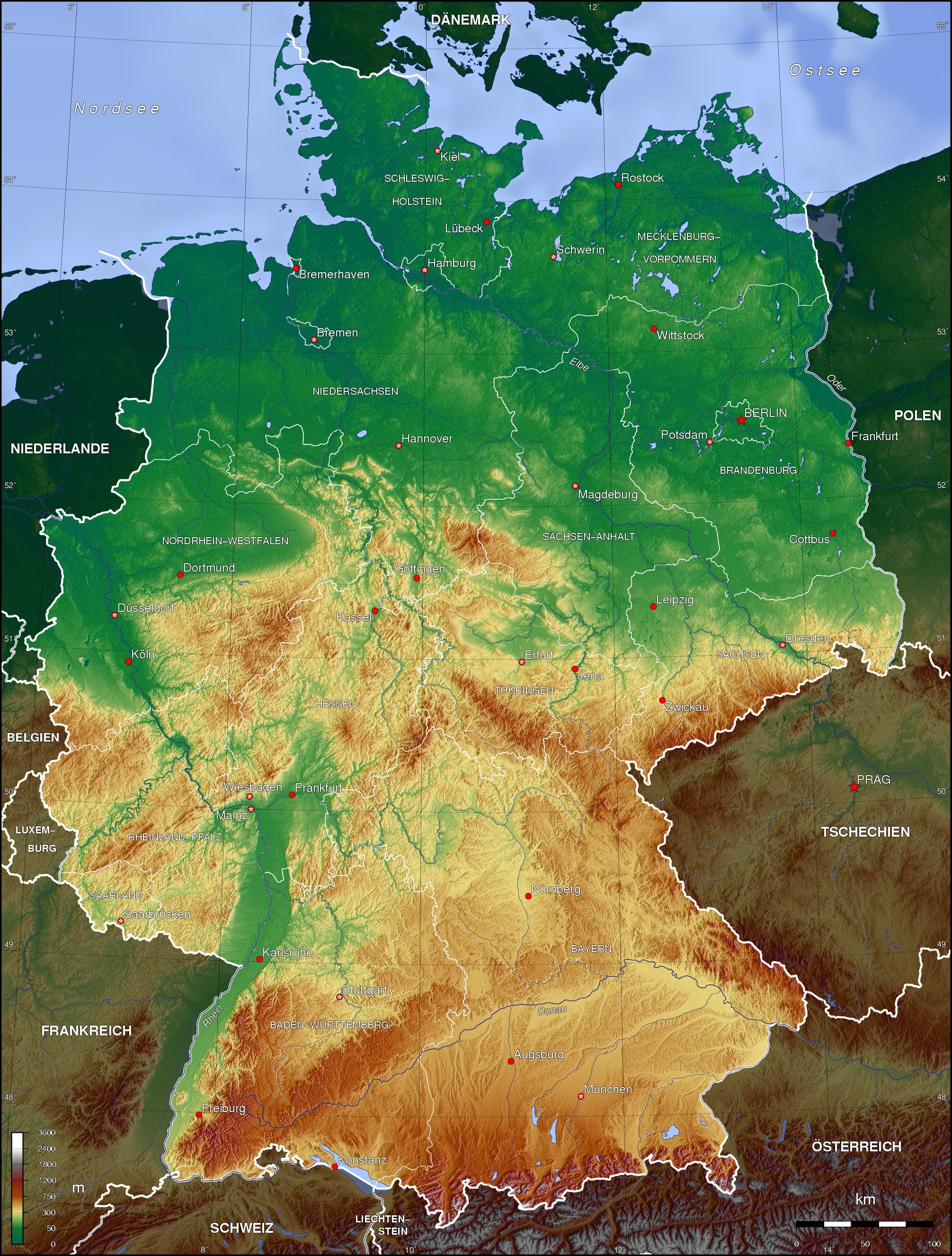
http://upload.wikimedia.org/wikipedia/c ... d_topo.jpgLinked above is an elevation map of the area. From this, I gather that there are some highlands at least on the eastern part of the border. There are also several rivers in the area, though none run through along that line. I guess your suggestion is to replace the mountains with a river? We can't have a wall of fog or anything like that, but as the rivers aren't perfectly accurate on this map anyway I suppose that that will work.
Seulessliathan wrote:and Rheinhessen is a strange name, never heard it anywhere, perhaps you better call it Westdeutschland? Rhein is the river, not the name for an area like Hessen. (and Rhein doesn´t go through Hessen) you combined the districts Rheinland-Pfalz & Hessen.
After a bit of Wiki browsing, it seems like Westdeutschland is the best alternative. I believe the continent was originally named Rheinhessen for this wine region:
http://en.wikipedia.org/wiki/Rheinhesse ... _region%29But I see now that that's a much too small area to represent the whole continent.
Only one concern: I don't know anything about this really, but the name "Westdeutschland" doesn't hold any touchy Cold War connotations does it?
Anyway, thanks for your comments everyone. Sorry it took me so long to respond.
You guys must have some wacky contrast on your monitors or it is indeed a form of color blindness. Nonetheless, it causes a real (and repeatable) problem on the map.


