By the way, there are 2 ports in Egypt, and Konya is still mistaken
WWI Ottoman Empire [Quenched]
Moderator: Cartographers
Re: WW1 1914 - THE OTTOMAN EMPIRE V6(P5) - Gallipoli added
![]() by Cdkutusu on Fri Aug 22, 2008 7:47 am
by Cdkutusu on Fri Aug 22, 2008 7:47 am
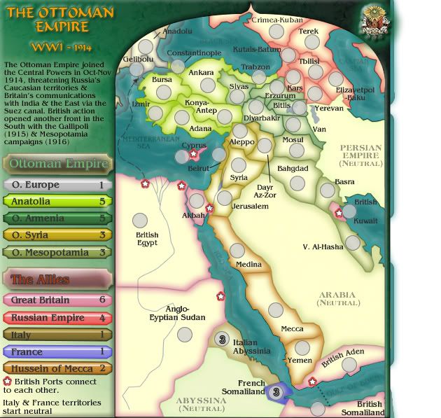
Now it looks better, I agree. But one more point, maybe you can add a special bonus for Ottoman zones, if player has both Europe Ottomans and Anatolian, +1 more? Or maybe Ottoman Europe can be +2, now it doesn't make so much sense to try holding it while there are easier targets in south.
By the way, there are 2 ports in Egypt, and Konya is still mistaken
By the way, there are 2 ports in Egypt, and Konya is still mistaken
-
 Cdkutusu
- Posts: 25
- Joined: Mon Jul 16, 2007 5:16 am


Re: WW1 1914 - THE OTTOMAN EMPIRE V6(P5) - Gallipoli added
![]() by cairnswk on Fri Aug 22, 2008 8:01 am
by cairnswk on Fri Aug 22, 2008 8:01 am
yeti_c wrote:OK first time viewing this one. (apologies if I've repeated anything)...
Points I can see upon first look.
a) "Italy& France start neutral" Consider renaming to "French & Italian territories start neutral" (feel free to swap "Territorry" with zone or whatever)
Done
Changed to Anadolu - Turkish as suggested by Cdkutusub) "Andrianople" -> "Adrianople" (Haven't looked at any other spellings) http://en.wikipedia.org/wiki/Adrianople
c) Eqypt appears to have 2 ports?
Yes - right is Port Said on Suez, although i think i have wrong side, and the other is Alexandria
I'll leave that for nowd) Consider adding width so that the sea can connect Kuwait visually.
yes...might have to do something like an inset window to handle that area for Gallipolie) Bursa <-> Gelipolu border is tricky to see (Is it actually a border or some sea?)
Donef) (N) - I would remove - or replace with (Neutral) as you have the space for it.
Doneg) Perhaps make Suez Canal wider by 1px? (as to show transport down it)
Goodh) Love the sea texture.
Donei) Consider I (captial i) instead of 1 in the WW1 title. (Or "The Great War")
Thanks C.Once again a great looking map Cairns...
C.
Version 7 below from changes above.

* Pearl Harbour * Waterloo * Forbidden City * Jamaica * Pot Mosbi
-

cairnswk
- Posts: 11510
- Joined: Sat Feb 03, 2007 8:32 pm
- Location: Australia


Re: WW1 1914 - THE OTTOMAN EMPIRE V6(P5) - Gallipoli added
![]() by cairnswk on Fri Aug 22, 2008 8:04 am
by cairnswk on Fri Aug 22, 2008 8:04 am
Cdkutusu wrote:Now it looks better, I agree. But one more point, maybe you can add a special bonus for Ottoman zones, if player has both Europe Ottomans and Anatolian, +1 more? Or maybe Ottoman Europe can be +2, now it doesn't make so much sense to try holding it while there are easier targets in south.
By the way, there are 2 ports in Egypt, and Konya is still mistaken
Konya is fixed above.
I will consider the bonuses....i think O Europe can be +2. yes?
* Pearl Harbour * Waterloo * Forbidden City * Jamaica * Pot Mosbi
-
cairnswk
- Posts: 11510
- Joined: Sat Feb 03, 2007 8:32 pm
- Location: Australia
Re: WW1 1914 - THE OTTOMAN EMPIRE V6(P5) - Gallipoli added
![]() by yeti_c on Fri Aug 22, 2008 8:11 am
by yeti_c on Fri Aug 22, 2008 8:11 am
cairnswk wrote:yeti_c wrote:a) "Italy& France start neutral" Consider renaming to "French & Italian territories start neutral" (feel free to swap "Territorry" with zone or whatever)
Done
You need to change "Italy" -> "Italian" & "France" -> "French" for it to make sense now though.
cairnswk wrote:yeti_c wrote:c) Eqypt appears to have 2 ports?
Yes - right is Port Said on Suez, although i think i have wrong side, and the other is Alexandria
Probably be less confusing if you remove the * from the 1 way to Bursa then?
Otherwise - good job - also - Gelibolu & Bursa looks a bit better already - did you lighten it slightly? (Ar am I seeing somethnig!)
C.

Highest score : 2297
-

yeti_c
- Posts: 9624
- Joined: Thu Jan 04, 2007 9:02 am


Re: WW1 1914 - THE OTTOMAN EMPIRE V6(P5) - Gallipoli added
![]() by MrBenn on Fri Aug 22, 2008 8:13 am
by MrBenn on Fri Aug 22, 2008 8:13 am
yeti_c wrote:cairnswk wrote:yeti_c wrote:a) "Italy& France start neutral" Consider renaming to "French & Italian territories start neutral" (feel free to swap "Territorry" with zone or whatever)
Done
You need to change "Italy" -> "Italian" & "France" -> "French" for it to make sense now though.
C.
Do you even need to put that on the legend? By the time the game starts, people are going to nitoce the neutrals

PB: 2661 | He's blue... If he were green he would die | No mod would be stupid enough to do that
-

MrBenn
- Posts: 6880
- Joined: Wed Nov 21, 2007 9:32 am
- Location: Off Duty


Re: WW1 1914 - THE OTTOMAN EMPIRE V6(P5) - Gallipoli added
![]() by yeti_c on Fri Aug 22, 2008 8:15 am
by yeti_c on Fri Aug 22, 2008 8:15 am
MrBenn wrote:yeti_c wrote:cairnswk wrote:yeti_c wrote:a) "Italy& France start neutral" Consider renaming to "French & Italian territories start neutral" (feel free to swap "Territorry" with zone or whatever)
Done
You need to change "Italy" -> "Italian" & "France" -> "French" for it to make sense now though.
C.
Do you even need to put that on the legend? By the time the game starts, people are going to nitoce the neutrals
Also a valid point - but Cairns likes that info to be available on the map - and not in the thread. (And if he can fit it in - then that's all fine by me!)
C.
Highest score : 2297
-
yeti_c
- Posts: 9624
- Joined: Thu Jan 04, 2007 9:02 am
Re: WW1 1914 - THE OTTOMAN EMPIRE V6(P5) - Gallipoli added
![]() by Cdkutusu on Fri Aug 22, 2008 8:18 am
by Cdkutusu on Fri Aug 22, 2008 8:18 am
Found the best version for old Adrianople (now Anadolu) - its Trakya, what we call to European part of Modern day Turkey.
One more thing, I guess you can add a separate territory for Alexandria, and add a bonus for Alexandria and Gelibolu together? Meaning that Gelibolu battle have been won and allies can drop reinforcements, or Ottoman empire held the attack and use reinforcements from there? +1 would look good, I guess
Maybe french can be connected to Sudan somehow, that way it will be more vulnerable to attacks, so it can balance the gameplay?
-
Cdkutusu
- Posts: 25
- Joined: Mon Jul 16, 2007 5:16 am
Re: WW1 1914 - THE OTTOMAN EMPIRE V6(P5) - Gallipoli added
![]() by AndyDufresne on Fri Aug 22, 2008 2:40 pm
by AndyDufresne on Fri Aug 22, 2008 2:40 pm
I'm liking the graphics to this map, Cairnswk...the graphics hook me in better than some of your recent maps (I don't mean that as insult!).
The port icons look a little out of place, for the era and graphic feel of the map...though I suppose it could be considered similar to the star on the Empire's flag.
I'd also consider lightening the background a little more behind the Historic Text in the legend, to make it slightly easier to read.
Additionally, I'm not sure I like the graphic effect of the horizontal line and color variation in the legend. What would it look like altered? Actually, I'm not sure about the whole legend, but it might just be the current colors.
Are you going to name this map, WW1: Ottoman Empire ?
--Andy
-

AndyDufresne
- Posts: 24935
- Joined: Fri Mar 03, 2006 8:22 pm
- Location: A Banana Palm in Zihuatanejo


Re: WW1 1914 - THE OTTOMAN EMPIRE V6(P5) - Gallipoli added
![]() by ZeakCytho on Fri Aug 22, 2008 5:40 pm
by ZeakCytho on Fri Aug 22, 2008 5:40 pm
Am I the only one who has trouble telling some of the continents apart? I'd prefer some more contrasting colors, if possible. The worst area is the junction of O. Armenia, O. Mesopotamia, and Russia.
-

ZeakCytho
- Posts: 1251
- Joined: Wed Sep 12, 2007 4:36 pm


Re: WW1 1914 - THE OTTOMAN EMPIRE V6(P5) - Gallipoli added
![]() by cairnswk on Fri Aug 22, 2008 6:04 pm
by cairnswk on Fri Aug 22, 2008 6:04 pm
yeti_c wrote:...
d) Consider adding width so that the sea can connect Kuwait visually...
C.
C, I checked the map size and adding the right side of the Arabian Peninsula would place the map outside the current restrictions. So to answer, I think this will have to remain as is. I don't want to scale down the tert sizes any less which is what would happen if i squeezed the map inwards.
yeti_c wrote:You need to change "Italy" -> "Italian" & "France" -> "French" for it to make sense now though.
Done
Probably be less confusing if you remove the * from the 1 way to Bursa then?
Otherwise - good job - also - Gelibolu & Bursa looks a bit better already - did you lighten it slightly? (Ar am I seeing somethnig!)
C.
Port Said * gone - Until i think about creating Alexandria as seperate tert.
The Dardenelles, no i just widened the Straights.
MrBenn wrote:Do you even need to put that on the legend? By the time the game starts, people are going to nitoce the neutrals
Well, i like it on the map while it is in development...so i don't have to answer the same silly bloody question all the time about who is starting starting neutral. It also reminds me when i program the xml about who starts neutral, and it can come off before the map goes live. So for now it is needed
Cdkutusu wrote:Found the best version for old Adrianople (now Anadolu) - its Trakya, what we call to European part of Modern day Turkey.
Can we stick with Anadolu?
One more thing, I guess you can add a separate territory for Alexandria, and add a bonus for Alexandria and Gelibolu together? Meaning that Gelibolu battle have been won and allies can drop reinforcements, or Ottoman empire held the attack and use reinforcements from there? +1 would look good, I guess
Oh, OK i get what you mean, that's probably a good idea to have Alexandria as a seperate tert.
Maybe french can be connected to Sudan somehow, that way it will be more vulnerable to attacks, so it can balance the gameplay?[/quote]
Mmmmm, let me think on that one please.
AndyDufresne wrote:I'm liking the graphics to this map, Cairnswk...the graphics hook me in better than some of your recent maps (I don't mean that as insult!).[/quote[
No offence taken, but i don't understand why you even have to go there The port icons look a little out of place, for the era and graphic feel of the map...though I suppose it could be considered similar to the star on the Empire's flag.
They can be worked on.Done, and moved next version.I'd also consider lightening the background a little more behind the Historic Text in the legend, to make it slightly easier to read.Additionally, I'm not sure I like the graphic effect of the horizontal line and color variation in the legend. What would it look like altered? Actually, I'm not sure about the whole legend, but it might just be the current colors.
I think the whole legend is going in for rework so hold on there....Are you going to name this map, WW1: Ottoman Empire ?
--Andy
Yes, that would good for the game finder/starter screen also. Thanks Andy for dropping in.
ZeakCytho wrote:Am I the only one who has trouble telling some of the continents apart? I'd prefer some more contrasting colors, if possible. The worst area is the junction of O. Armenia, O. Mesopotamia, and Russia.
Probably, until oaktown arrives and changes everything anyway, so once again....hold one and watch this space
* Pearl Harbour * Waterloo * Forbidden City * Jamaica * Pot Mosbi
-
cairnswk
- Posts: 11510
- Joined: Sat Feb 03, 2007 8:32 pm
- Location: Australia
Re: WWI: OTTOMAN EMPIRE V8 - Inset added
![]() by cairnswk on Fri Aug 22, 2008 6:44 pm
by cairnswk on Fri Aug 22, 2008 6:44 pm
Version 8
This version introduces the inset for Gelibolu (Gollipoli) to enhance the one-way attacks in that region.
Please don't comment on the legend as it is begin re-worked.
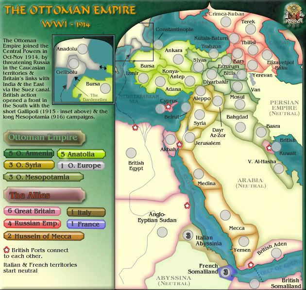
This version introduces the inset for Gelibolu (Gollipoli) to enhance the one-way attacks in that region.
Please don't comment on the legend as it is begin re-worked.
* Pearl Harbour * Waterloo * Forbidden City * Jamaica * Pot Mosbi
-
cairnswk
- Posts: 11510
- Joined: Sat Feb 03, 2007 8:32 pm
- Location: Australia
Re: WWI: OTTOMAN EMPIRE V8(P6) - Gallipoli inset added
![]() by ZeakCytho on Fri Aug 22, 2008 6:48 pm
by ZeakCytho on Fri Aug 22, 2008 6:48 pm
Could you maybe put the words British Egypt and Constantinople in the insert where their respecitve arrows come from? And on the main map, maybe make the box around the insert a bit thicker?
-
ZeakCytho
- Posts: 1251
- Joined: Wed Sep 12, 2007 4:36 pm
Re: WWI: OTTOMAN EMPIRE V8(P6) - Gallipoli inset added
![]() by edbeard on Fri Aug 22, 2008 6:53 pm
by edbeard on Fri Aug 22, 2008 6:53 pm
good progress on this one
I still feel like the colour of Armenia on the legend and the playable area don't match. It's probably an illusion but anything you can do to make them appear more similar? The playable one is softer than the full green on the legend.
I'd move the Jerusalem text label away from the Dayr Az-Zor one a bit. I'd also move the Kutais-Batum one north slightly.
The Dardenelles part of the inset might just confuse people.
O. Syria is probably worth 4 armies. 4 borders from 5 territories and it touches 5 continents.
I'd almost drop the Hussein of Mecca bonus down to because when you compare it to something like Russian Empire or O. Syria (if you gave it a 4 bonus), it seems way too easy to hold. Any possibility of adding more territories in there to make it more worth a 2 bonus?
-

edbeard
- Posts: 2501
- Joined: Thu Mar 29, 2007 12:41 am


Re: WWI: OTTOMAN EMPIRE V8(P6) - Gallipoli inset added
![]() by cairnswk on Fri Aug 22, 2008 7:54 pm
by cairnswk on Fri Aug 22, 2008 7:54 pm
edbeard wrote:good progress on this one
I still feel like the colour of Armenia on the legend and the playable area don't match. It's probably an illusion but anything you can do to make them appear more similar? The playable one is softer than the full green on the legend.
Yes look...can we hold off on comments about the colors just for now as they are all going to change probably when oaktown arrives for comment.
DoneI'd move the Jerusalem text label away from the Dayr Az-Zor one a bit. I'd also move the Kutais-Batum one north slightly.
DoneThe Dardenelles part of the inset might just confuse people.
Done
O. Syria is probably worth 4 armies. 4 borders from 5 territories and it touches 5 continents.
I'd almost drop the Hussein of Mecca bonus down to (too) because when you compare it to something like Russian Empire or O. Syria (if you gave it a 4 bonus), it seems way too easy to hold.
I think it is worth a 2 simply because it is linear and has 2 borders to defend.
Any possibility of adding more territories in there to make it more worth a 2 bonus?
I don't think so.
2T / 2D/ 2A / 2N = +1
3T / 2D/ 2A / 2N = +2
And historically, no. Sorry.
* Pearl Harbour * Waterloo * Forbidden City * Jamaica * Pot Mosbi
-
cairnswk
- Posts: 11510
- Joined: Sat Feb 03, 2007 8:32 pm
- Location: Australia
Re: WWI: OTTOMAN EMPIRE V8(P6) - Gallipoli inset added
![]() by cairnswk on Fri Aug 22, 2008 7:58 pm
by cairnswk on Fri Aug 22, 2008 7:58 pm
ZeakCytho wrote:Could you maybe put the words British Egypt and Constantinople in the insert where their respecitve arrows come from? And on the main map, maybe make the box around the insert a bit thicker?
Zeak, can we revisit that one later....i just tried putting those words in there...from Alexandria fits...
but Constantinople doesn't (nicely anyways) <- and it looks like a complete double up
so i'd like to revisit that later again please.
* Pearl Harbour * Waterloo * Forbidden City * Jamaica * Pot Mosbi
-
cairnswk
- Posts: 11510
- Joined: Sat Feb 03, 2007 8:32 pm
- Location: Australia
Re: WWI: OTTOMAN EMPIRE V8(P6) - Gallipoli inset added
![]() by Cdkutusu on Sat Aug 23, 2008 3:44 am
by Cdkutusu on Sat Aug 23, 2008 3:44 am
Good progress with this version.
I still think it can be nice if there will be a bonus for Alexandria + Gelibolu Dont have any idea how much work does it need though, so its up to you.
Other than that, Trakya would have been nicer, but if you are bored with changing the names every day, let it stay
I also think Syria should be 4.
Generally in this map trying to hold south looks like a better way to get more bonuses. Some isolated regions, less connections etc. So it can be better if you reduce their bonuses, or improve Ottoman bonuses. Just my thinking though, its up to you
Keep up the good work, map gets better every day
I still think it can be nice if there will be a bonus for Alexandria + Gelibolu
Other than that, Trakya would have been nicer, but if you are bored with changing the names every day, let it stay
I also think Syria should be 4.
Generally in this map trying to hold south looks like a better way to get more bonuses. Some isolated regions, less connections etc. So it can be better if you reduce their bonuses, or improve Ottoman bonuses. Just my thinking though, its up to you
Keep up the good work, map gets better every day
-
Cdkutusu
- Posts: 25
- Joined: Mon Jul 16, 2007 5:16 am
Re: WWI: OTTOMAN EMPIRE V8 - Inset added
![]() by cairnswk on Sat Aug 23, 2008 3:59 am
by cairnswk on Sat Aug 23, 2008 3:59 am
Current Version 8
* Pearl Harbour * Waterloo * Forbidden City * Jamaica * Pot Mosbi
-
cairnswk
- Posts: 11510
- Joined: Sat Feb 03, 2007 8:32 pm
- Location: Australia
Re: WWI: OTTOMAN EMPIRE V8(P6) - Gallipoli inset added
![]() by cairnswk on Sat Aug 23, 2008 4:02 am
by cairnswk on Sat Aug 23, 2008 4:02 am
Cdkutusu wrote:...Other than that, Trakya would have been nicer, but if you are bored with changing the names every day, let it stay
No not bored changing names, but was it known as Trakya back in 1914?
Because all the maps i have seen (in English) called it Andianopole? or something like that.
So i only am concerned that all this name changing is not making the name historically incorrect.
* Pearl Harbour * Waterloo * Forbidden City * Jamaica * Pot Mosbi
-
cairnswk
- Posts: 11510
- Joined: Sat Feb 03, 2007 8:32 pm
- Location: Australia
Re: WWI: OTTOMAN EMPIRE V8(P6) - Gallipoli inset added
![]() by Cdkutusu on Sat Aug 23, 2008 4:41 am
by Cdkutusu on Sat Aug 23, 2008 4:41 am
Well, probably no. It may have been known as Rumeli in Turkish, but not sure.
-
Cdkutusu
- Posts: 25
- Joined: Mon Jul 16, 2007 5:16 am
Re: WWI: OTTOMAN EMPIRE V8(P6) - Gallipoli inset added
![]() by cairnswk on Sat Aug 23, 2008 5:05 am
by cairnswk on Sat Aug 23, 2008 5:05 am
Cdkutusu wrote:Well, probably no. It may have been known as Rumeli in Turkish, but not sure.
If that stands for Romania, then that's probably wrong because the maps i looked at say it was Adrianople with Bulgaria behind it
* Pearl Harbour * Waterloo * Forbidden City * Jamaica * Pot Mosbi
-
cairnswk
- Posts: 11510
- Joined: Sat Feb 03, 2007 8:32 pm
- Location: Australia
Re: WWI: OTTOMAN EMPIRE V8(P6) - Gallipoli inset added
![]() by Cdkutusu on Sat Aug 23, 2008 6:22 am
by Cdkutusu on Sat Aug 23, 2008 6:22 am
No Romania is Romania Rumeli is for European part, but not so sure if that was used at that time.
-
Cdkutusu
- Posts: 25
- Joined: Mon Jul 16, 2007 5:16 am
Re: WW1 1914 - THE OTTOMAN EMPIRE V6(P5) - Gallipoli added
![]() by yeti_c on Sat Aug 23, 2008 2:17 pm
by yeti_c on Sat Aug 23, 2008 2:17 pm
cairnswk wrote:yeti_c wrote:...
d) Consider adding width so that the sea can connect Kuwait visually...
C.
C, I checked the map size and adding the right side of the Arabian Peninsula would place the map outside the current restrictions. So to answer, I think this will have to remain as is. I don't want to scale down the tert sizes any less which is what would happen if i squeezed the map inwards.
Shame - but I understand - unless you could modify the arabian peninsula -> Although I'd understand if you didn't want to do that as it wouldn't be geographically accurate.
C.
Highest score : 2297
-
yeti_c
- Posts: 9624
- Joined: Thu Jan 04, 2007 9:02 am
Re: WW1 1914 - THE OTTOMAN EMPIRE V6(P5) - Gallipoli added
![]() by cairnswk on Sat Aug 23, 2008 4:07 pm
by cairnswk on Sat Aug 23, 2008 4:07 pm
yeti_c wrote:cairnswk wrote:yeti_c wrote:...
d) Consider adding width so that the sea can connect Kuwait visually...
C.
C, I checked the map size and adding the right side of the Arabian Peninsula would place the map outside the current restrictions. So to answer, I think this will have to remain as is. I don't want to scale down the tert sizes any less which is what would happen if i squeezed the map inwards.
Shame - but I understand - unless you could modify the arabian peninsula -> Although I'd understand if you didn't want to do that as it wouldn't be geographically accurate.
C.
C...i think that while it would look good from a map perspective, i think everyone knows that Kuwait can connect to the Gulf of Eden and that there is sea all around the Arabian Pen. I just can't justify spending the time on doing that, and making the A. Pen. look less than what it is.
* Pearl Harbour * Waterloo * Forbidden City * Jamaica * Pot Mosbi
-
cairnswk
- Posts: 11510
- Joined: Sat Feb 03, 2007 8:32 pm
- Location: Australia
Re: WWI: OTTOMAN EMPIRE V8(P6) - Gallipoli inset added
![]() by Mr. Squirrel on Sat Aug 23, 2008 5:02 pm
by Mr. Squirrel on Sat Aug 23, 2008 5:02 pm
I'm thinking, why not instead of having separate bonuses for Britain, France, and Italy, you give one large blanket bonus for all of their colonies. Because right now, holding all three will yield a bonus of eight while you only have to protect three borders. I think that is a bit over powered. Instead just call the bonus "European colonies" or something like that and give it a bonus of 6 or so.
-

Mr. Squirrel
- Posts: 157
- Joined: Fri Nov 02, 2007 3:18 pm
- Location: up a tree
Re: WWI: OTTOMAN EMPIRE V8(P6) - Gallipoli inset added
![]() by ZeakCytho on Sat Aug 23, 2008 5:05 pm
by ZeakCytho on Sat Aug 23, 2008 5:05 pm
cairnswk wrote:ZeakCytho wrote:Could you maybe put the words British Egypt and Constantinople in the insert where their respecitve arrows come from? And on the main map, maybe make the box around the insert a bit thicker?
Zeak, can we revisit that one later....i just tried putting those words in there...from Alexandria fits...
but Constantinople doesn't (nicely anyways) <- and it looks like a complete double up
so i'd like to revisit that later again please.
Sure thing. I can bug you about this once you're in the main foundry if you want
If they don't fit nicely, then I think the map is better without them.
-
ZeakCytho
- Posts: 1251
- Joined: Wed Sep 12, 2007 4:36 pm
Who is online
Users browsing this forum: No registered users
|
|||||||
| Conquer Club is not associated with RISK online in any way. Copyright © 2006-2025 by Big Wham LLC | |||||||