First Nations Americas.
Moderator: Cartographers
Re: First Nations combined
![]() by Kabanellas on Fri Jan 28, 2011 12:33 pm
by Kabanellas on Fri Jan 28, 2011 12:33 pm
it's looking awesome !!!!!!!!!!!!!!! 

-
 Kabanellas
- Posts: 1482
- Joined: Fri Feb 27, 2009 12:21 pm
- Location: Porto, Portugal


Re: First Nations combined
![]() by MrBenn on Fri Jan 28, 2011 1:58 pm
by MrBenn on Fri Jan 28, 2011 1:58 pm
It's back.....


PB: 2661 | He's blue... If he were green he would die | No mod would be stupid enough to do that
-

MrBenn
- Posts: 6880
- Joined: Wed Nov 21, 2007 9:32 am
- Location: Off Duty


Re: First Nations combined
![]() by grifftron on Fri Jan 28, 2011 2:48 pm
by grifftron on Fri Jan 28, 2011 2:48 pm
MrBenn wrote:It's back.....
Will this one pretty much go right thru the foundry since both maps are already out and quenched.. just the little new connectors i guess and its up? I think it would be best to have this as the first / one of the first out on the mega maps.
-griff

-

grifftron
- SoC Training Adviser
- Posts: 3280
- Joined: Thu Jul 09, 2009 6:11 am


Re: First Nations combined
![]() by esiemer on Fri Jan 28, 2011 8:50 pm
by esiemer on Fri Jan 28, 2011 8:50 pm
that is a thing of beauty indeed... wow.
-

esiemer
- Posts: 72
- Joined: Sat Jan 30, 2010 8:22 pm


Re: First Nations combined
![]() by Victor Sullivan on Fri Jan 28, 2011 11:46 pm
by Victor Sullivan on Fri Jan 28, 2011 11:46 pm
ABSOLUTELY AMAZING TISHA!!! Hearts a-plenty for you! <3 I have some comments/suggestions:
-Sully
P.S. OMFG THE DRAFT STAMP!!!
P.S.S. Suck this map, World 2.1!
- The sea territories are freakin' brilliant.
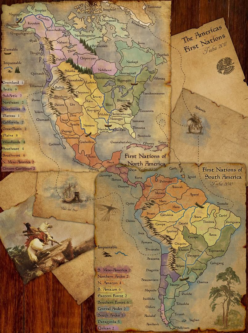
- North and South Meso America, as well as Circum-Caribbean, all need to be upped to +3, as they each have 3 borders now, as opposed to the original 2.
- For the title, might I suggest "First Nations of the Americas"? That way it will be next to the other two First Nations maps in the game finder.
- More of a graphics suggestion - change the red, purple, and orange on either North or South America, as those same colors appear close to the same colors in the opposite America. Though with the legends as they are, it may not be necessary. Ultimately, your choice.
-Sully
P.S. OMFG THE DRAFT STAMP!!!
P.S.S. Suck this map, World 2.1!
Beckytheblondie: "Don't give us the dispatch, give us a mustache ride."
Scaling back on my CC involvement...
Scaling back on my CC involvement...
-

Victor Sullivan
- Posts: 6010
- Joined: Mon Feb 08, 2010 8:17 pm
- Location: Columbus, OH


Re: First Nations combined
![]() by BlackandYellow on Sat Jan 29, 2011 12:53 am
by BlackandYellow on Sat Jan 29, 2011 12:53 am
Amazing
i love it
but i do agree with natty_dead
combining the meso-americas would bring the map together
i love it
but i do agree with natty_dead
combining the meso-americas would bring the map together
-
BlackandYellow
- Posts: 1
- Joined: Fri Jan 28, 2011 12:06 am
Re: First Nations combined
![]() by bedub1 on Sat Jan 29, 2011 1:18 am
by bedub1 on Sat Jan 29, 2011 1:18 am
EDIT: Oops..this is the Gameplay Workshop and not the Graphics Workshop...my bad. I have nothing useful to add to the discussion.
Last edited by bedub1 on Mon Jan 31, 2011 10:34 pm, edited 1 time in total.
-
bedub1
- Posts: 1005
- Joined: Sun Dec 31, 2006 4:41 am

Re: First Nations combined
![]() by Tisha on Sat Jan 29, 2011 1:25 am
by Tisha on Sat Jan 29, 2011 1:25 am
greenoaks wrote:will the ship to the east and west become a terit ?
yes
Victor Sullivan wrote:
- North and South Meso America, as well as Circum-Caribbean, all need to be upped to +3, as they each have 3 borders now, as opposed to the original 2.
- For the title, might I suggest "First Nations of the Americas"? That way it will be next to the other two First Nations maps in the game finder.
- More of a graphics suggestion - change the red, purple, and orange on either North or South America, as those same colors appear close to the same colors in the opposite America. Though with the legends as they are, it may not be necessary. Ultimately, your choice.
-Sully
if I change like Circum-Caribbean, then It seems I have to change Great Basin also, no? N Meso didn't change that much in it's connection, but I did think about upping S. Meso.
would rather keep the territory colors how they are. they seem obvious to me.. with the legends
natty_dread wrote:This is just an idea/opinion, but I think you could combine the 2 meso-americas into a single bonus... it would sort of bring the map together into a more coherent whole.
I definitely don't wanna combine the edges of the map together and make one massive bonus down there
I know I need better names for the ships, but are those better connections for the west ship?
- Click image to enlarge.
-

Tisha
- Posts: 1065
- Joined: Sat Dec 23, 2006 12:41 am


Re: First Nations combined
![]() by The Bison King on Sat Jan 29, 2011 10:37 am
by The Bison King on Sat Jan 29, 2011 10:37 am
Will the boats be regular territories or killer neutrals?

-

The Bison King
- Posts: 1957
- Joined: Thu Aug 27, 2009 5:06 pm
- Location: the Mid-Westeros


Re: First Nations combined
![]() by Tisha on Sat Jan 29, 2011 12:28 pm
by Tisha on Sat Jan 29, 2011 12:28 pm
The Bison King wrote:Will the boats be regular territories or killer neutrals?
I wasn't thinking of killer neutrals, I was just thinking neutrals. 74 territories, and 71 is Ideal. I was thinking neutrals on the boats and Nimiipuu.
-
Tisha
- Posts: 1065
- Joined: Sat Dec 23, 2006 12:41 am
Re: First Nations combined
![]() by Industrial Helix on Sat Jan 29, 2011 12:28 pm
by Industrial Helix on Sat Jan 29, 2011 12:28 pm
Yeah, i agree. Don't combine Mesoamerica.
For the ships, what about significant European ship names in the discovery of the new world? Magellan circumnavigated the world in the Victoria. Columbus came in via the Niña. Those could be the Pacific and Atlantic ships respectively.
Also... the title seems strange to me. What about simply "First Nations of the Americas."
Sketchblog [Update 07/25/11]: http://indyhelixsketch.blogspot.com/
Living in Japan [Update 07/17/11]: http://mirrorcountryih.blogspot.com/
Russian Revolution map for ConquerClub [07/20/11]: viewtopic.php?f=241&t=116575
Living in Japan [Update 07/17/11]: http://mirrorcountryih.blogspot.com/
Russian Revolution map for ConquerClub [07/20/11]: viewtopic.php?f=241&t=116575
-

Industrial Helix
- Posts: 3462
- Joined: Mon Jul 14, 2008 6:49 pm
- Location: Ohio


Re: First Nations combined
![]() by MrBenn on Sat Jan 29, 2011 2:51 pm
by MrBenn on Sat Jan 29, 2011 2:51 pm
"On August 3, 1492, Christopher Columbus set sail from Spain with three small Spanish sailing ships, the Pinta, the Niña, and the Santa María"
PB: 2661 | He's blue... If he were green he would die | No mod would be stupid enough to do that
-
MrBenn
- Posts: 6880
- Joined: Wed Nov 21, 2007 9:32 am
- Location: Off Duty
Re: First Nations combined
![]() by isaiah40 on Sat Jan 29, 2011 3:06 pm
by isaiah40 on Sat Jan 29, 2011 3:06 pm
The Meso Americas should be left as is!
I'm wondering if there should be an attack route from the Pacific ship to one of the Meso America territories? Maybe to Chorotega?
What he said.
I'm wondering if there should be an attack route from the Pacific ship to one of the Meso America territories? Maybe to Chorotega?
Industrial Helix wrote:For the ships, what about significant European ship names in the discovery of the new world? Magellan circumnavigated the world in the Victoria. Columbus came in via the Niña. Those could be the Pacific and Atlantic ships respectively.
What he said.
-
isaiah40
- Posts: 3990
- Joined: Mon Aug 27, 2007 7:14 pm

Re: First Nations combined
![]() by Tisha on Sun Jan 30, 2011 12:11 pm
by Tisha on Sun Jan 30, 2011 12:11 pm
I changes the title, and the names of the ships.
what else?
Make South Meso-America 3?
what about where the two meso americas meet? draw a border right on the edge of the paper?
connect the Victoria to Tarascan?
neutrals on the boats and Nimiipuu?
what else?
Make South Meso-America 3?
what about where the two meso americas meet? draw a border right on the edge of the paper?
connect the Victoria to Tarascan?
neutrals on the boats and Nimiipuu?
-
Tisha
- Posts: 1065
- Joined: Sat Dec 23, 2006 12:41 am
Re: First Nations combined
![]() by isaiah40 on Sun Jan 30, 2011 12:32 pm
by isaiah40 on Sun Jan 30, 2011 12:32 pm
Tisha wrote:I changes the title, and the names of the ships.
what else?
1)Make South Meso-America 3?
2)what about where the two meso americas meet? draw a border right on the edge of the paper?
3)connect the Victoria to Tarascan?
4)neutrals on the boats and Nimiipuu?
1) I would be more inclined to increase North Meso America by 1 - see point 3
2)I'd say draw the line on the edge of the paper to divide the two meso americas to avoid any confusion.
3)Yes connect the Victoria to Tarascan.
4)2 neutrals on the boats and 3 on Nimiipuu.
-
isaiah40
- Posts: 3990
- Joined: Mon Aug 27, 2007 7:14 pm
Re: First Nations combined
![]() by Tisha on Sun Jan 30, 2011 2:21 pm
by Tisha on Sun Jan 30, 2011 2:21 pm
isaiah40 wrote:Tisha wrote:I changes the title, and the names of the ships.
what else?
1)Make South Meso-America 3?
2)what about where the two meso americas meet? draw a border right on the edge of the paper?
3)connect the Victoria to Tarascan?
4)neutrals on the boats and Nimiipuu?
1) I would be more inclined to increase North Meso America by 1 - see point 3
2)I'd say draw the line on the edge of the paper to divide the two meso americas to avoid any confusion.
3)Yes connect the Victoria to Tarascan.
4)2 neutrals on the boats and 3 on Nimiipuu.
well then I would wanna increase south by one also, since they both have three borders, and the south has one more territory than the north.
-
Tisha
- Posts: 1065
- Joined: Sat Dec 23, 2006 12:41 am
Re: First Nations combined
![]() by neanderpaul14 on Sun Jan 30, 2011 4:26 pm
by neanderpaul14 on Sun Jan 30, 2011 4:26 pm
Looks awesome.....can't wait to play it.

High score: 2724/#163 on scoreboard/COLONEL
-

neanderpaul14
- Posts: 1216
- Joined: Wed Aug 06, 2008 3:52 pm
- Location: "Always mystify, mislead and surprise the enemy if possible." - Thomas J. Jackson


Re: First Nations combined
![]() by Industrial Helix on Sun Jan 30, 2011 4:51 pm
by Industrial Helix on Sun Jan 30, 2011 4:51 pm
MrBenn wrote:"On August 3, 1492, Christopher Columbus set sail from Spain with three small Spanish sailing ships, the Pinta, the Niña, and the Santa María"
Yes, but the Niña was his favorite.
So i still vote call it the Niña or find an image with 3 ships and call it the Niña, the Pinta and the Santa María.
Sketchblog [Update 07/25/11]: http://indyhelixsketch.blogspot.com/
Living in Japan [Update 07/17/11]: http://mirrorcountryih.blogspot.com/
Russian Revolution map for ConquerClub [07/20/11]: viewtopic.php?f=241&t=116575
Living in Japan [Update 07/17/11]: http://mirrorcountryih.blogspot.com/
Russian Revolution map for ConquerClub [07/20/11]: viewtopic.php?f=241&t=116575
-
Industrial Helix
- Posts: 3462
- Joined: Mon Jul 14, 2008 6:49 pm
- Location: Ohio
Re: First Nations combined
![]() by benga on Sun Jan 30, 2011 5:08 pm
by benga on Sun Jan 30, 2011 5:08 pm
Go for it, looks beautiful!
Can't wait!!
Can't wait!!
-

benga
- Posts: 6925
- Joined: Tue Nov 17, 2009 4:15 pm


Re: First Nations combined
![]() by Tisha on Sun Jan 30, 2011 6:44 pm
by Tisha on Sun Jan 30, 2011 6:44 pm
Industrial Helix wrote:MrBenn wrote:"On August 3, 1492, Christopher Columbus set sail from Spain with three small Spanish sailing ships, the Pinta, the Niña, and the Santa María"
Yes, but the Niña was his favorite.
So i still vote call it the Niña or find an image with 3 ships and call it the Niña, the Pinta and the Santa María.
the Nina is the only one that made the complete trip.. he started out on the Santa Maria..
same as the Victoria, the guy started out on the Trinidad.. but it didn't work out so well..
I picked Victoria and Nina.
-
Tisha
- Posts: 1065
- Joined: Sat Dec 23, 2006 12:41 am
Re: First Nations combined
![]() by lostatlimbo on Sun Jan 30, 2011 6:55 pm
by lostatlimbo on Sun Jan 30, 2011 6:55 pm
This looks awesome. Hope it makes it through foundry quickly, since the maps are already established.
-

lostatlimbo
- Posts: 1386
- Joined: Wed Mar 28, 2007 3:56 pm
- Location: Portland, OR


Re: First Nations combined
![]() by natty dread on Sun Jan 30, 2011 7:03 pm
by natty dread on Sun Jan 30, 2011 7:03 pm
Did you seriously use the words "foundry" and "quickly" in the same sentence?

-

natty dread
- Posts: 12877
- Joined: Fri Feb 08, 2008 8:58 pm
- Location: just plain fucked


Re: First Nations combined
![]() by MrBenn on Sun Jan 30, 2011 7:24 pm
by MrBenn on Sun Jan 30, 2011 7:24 pm
Tisha wrote:what about where the two meso americas meet? draw a border right on the edge of the paper?
You shouldn;t need to draw a border at all; if you want to enhance it, just add slightly more shadow where the pages overlap. This should be more than sufficient.
isaiah40 wrote:Tisha wrote:3)connect the Victoria to Tarascan?
4)neutrals on the boats and Nimiipuu?
3)Yes connect the Victoria to Tarascan.
Actually, I would suggest reverting back to something almost like you had originally for the connections on the Pacific ocean side of the map. With the proximity of the connections across both sides of the map, the Meso-Americas become even more of a bottle neck; having the cross-map connections converging in the middle sort-of defeats the point of adding them in the first place?
If the path across the sea is redrawn to go beneath the bird and around it to the left, then it would be a better approximation of actual established sea trading routes. I'd take the path from Diaguita to Romo to reflect actual sailing routes:
PB: 2661 | He's blue... If he were green he would die | No mod would be stupid enough to do that
-
MrBenn
- Posts: 6880
- Joined: Wed Nov 21, 2007 9:32 am
- Location: Off Duty
Re: First Nations combined
![]() by Tisha on Sun Jan 30, 2011 7:50 pm
by Tisha on Sun Jan 30, 2011 7:50 pm
MrBenn wrote:Actually, I would suggest reverting back to something almost like you had originally for the connections on the Pacific ocean side of the map. With the proximity of the connections across both sides of the map, the Meso-Americas become even more of a bottle neck; having the cross-map connections converging in the middle sort-of defeats the point of adding them in the first place?
If the path across the sea is redrawn to go beneath the bird and around it to the left, then it would be a better approximation of actual established sea trading routes. I'd take the path from Diaguita to Romo to reflect actual sailing routes:
I don't understand?
the left of the bird, I got.
two connections from Victoria? Maybe just Chumash and Chimu?
-
Tisha
- Posts: 1065
- Joined: Sat Dec 23, 2006 12:41 am
Re: First Nations combined
![]() by Victor Sullivan on Mon Jan 31, 2011 6:10 am
by Victor Sullivan on Mon Jan 31, 2011 6:10 am
Victor Sullivan wrote:3. For the title, might I suggest "First Nations of the Americas"? That way it will be next to the other two First Nations maps in the game finder.
Industrial Helix wrote:Also... the title seems strange to me. What about simply "First Nations of the Americas."
Thanks, IH, just in case she didn't get it the first time, lol...
Would you mind posting your updated map so far, Tisha? It sounds like you've been making the changes, but it'd be nice to see them as you go.
-Sully
Beckytheblondie: "Don't give us the dispatch, give us a mustache ride."
Scaling back on my CC involvement...
Scaling back on my CC involvement...
-
Victor Sullivan
- Posts: 6010
- Joined: Mon Feb 08, 2010 8:17 pm
- Location: Columbus, OH
Who is online
Users browsing this forum: No registered users
|
|||||||
| Conquer Club is not associated with RISK online in any way. Copyright © 2006-2024 by Big Wham LLC | |||||||