Conquer Club

Vancouver [Quenched]

Care to peruse completed maps? Take a stroll through the Atlas.

Moderator: Cartographers

Forum rules
Please read the Community Guidelines before posting.

Re: Vancouver Map

Postby TaCktiX on Wed Mar 25, 2009 12:28 pm

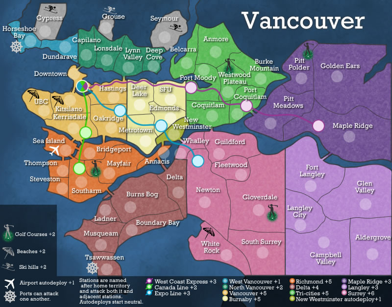
iancanton wrote:if u were starting from scratch, then i'd have urged u to eliminate maple ridge and langley and concentrate ur map on the best-known and most interesting parts of the city. other than the transit lines, ur current map currently takes much the same approach as the neighbouring puget sound map: perfectly good in most respects, except that it doesn't quite have enough to grab the attention and make people want to play it more than some other map. someone else tried to make a london (uk) map that was based purely on its administrative divisions; not surprisingly, people lost interest before it hit the main foundry.


Ian has it on the dot. The map looks good, but it really is missing enough pizazz or uniqueness to keep interest going throughout the process. I wasn't around when Puget Sound hit Forge, but I heard that Tisha's map got utterly obliterated by feedback and only through tons of improvements did it get quenched. To avoid this, I would definitely suggest bringing in more of Vancouver into the map. Right now it's a more or less factual layout of the neighborhoods and boroughs of the city. Rose City takes advantage of what makes Portland its namesake. Build those into the map, either with visual cues, outright bonuses, or otherwise. You might end up having to redesign the map entirely, but make it so that when we look at your map, we can't help but be reminded "you know, that is Vancouver."
User avatar
Corporal 1st Class TaCktiX
 
Posts: 2392
Joined: Mon Dec 17, 2007 8:24 pm
Location: Rapid City, SD

Re: Vancouver Map [D] (19 Mar - p10)

Postby shakeycat on Wed Mar 25, 2009 6:42 pm

What if we did something like:

Click image to enlarge.
image


it's a bit rough yet. Is terribly crowded. I suppose the airport isn't that important, though the ports and transit keep things moving. Someone suggested earlier about adding the three ski hills up top, so they will have their own territories. I could either slice beaches off into their own territories or just make them an additional bonus, ditto for golf courses.

Is there anything else I'm missing? Fish market at Steveston, Horseback riding in Campbell Valley, Hiking at Golden Ears? Bird Watching at Musqueam, history in Fort Langley, Malliardville? Arts in Port Moody? a bonus for good parks - Deer Lake, Newton's Bear Creek? Or perhaps even something that would create a negative bonus.

And what do you think of the little men? Is it as easy as placing a little guy, or should I make more effort to recreate the geography (ski hill with visible snow covered runs, golf course as a green plot, beaches sandy)? If a little guy is fine, does he have colour, or just a silhouette? Or the odd mix I put out, of silhouettes with coloured bits.

(I do not update this on the front page, because it isn't pretty yet.)
Last edited by shakeycat on Wed Mar 25, 2009 11:39 pm, edited 2 times in total.
User avatar
Lieutenant shakeycat
 
Posts: 390
Joined: Sun Mar 11, 2007 5:13 am
Location: Vancouver

Re: Vancouver Map [D] (19 Mar - p10)

Postby Joodoo on Wed Mar 25, 2009 6:47 pm

I like the idea of new bonuses that involve territories not adjacent to each other...
TheSaxlad wrote:The Dice suck a lot of the time.

And if they dont suck then they blow.

:D
User avatar
Lieutenant Joodoo
 
Posts: 1639
Joined: Fri Mar 21, 2008 12:19 am
Location: Greater Toronto, Canada

Re: Vancouver Map [D] (19 Mar - p10)

Postby shakeycat on Thu Mar 26, 2009 6:32 pm

or maybe
Click image to enlarge.
image


Added the bird sanctuary, nixed the bonus circles where it made things too crowded, drew in little beaches .. how about it?

Bonuses are split between territories, outdoor recreation, and wildlife. Steveston's fish market, Campbell Valley (or should it be Aldergrove?) for horses, Anmore - where there's more bears than people, the George C. Reifel Bird Sanctuary just off Ladner, Boundary Bay which is great for seeing heron and birds of prey.
User avatar
Lieutenant shakeycat
 
Posts: 390
Joined: Sun Mar 11, 2007 5:13 am
Location: Vancouver

Re: Vancouver Map [D] (26 Mar - p11)

Postby Bavarian Raven on Mon Mar 30, 2009 5:35 pm

add a bear to goldenears ;)
Sergeant 1st Class Bavarian Raven
 
Posts: 261
Joined: Fri Nov 17, 2006 10:52 pm
Location: Canada, Vancouver

Re: Vancouver Map [D] (26 Mar - p11)

Postby shakeycat on Mon Mar 30, 2009 5:54 pm

Should it be a bear like Anmore or is there a different animal they're famous for? Beaver, deer, mountain goat?
Current Map Project: Tokyo
User avatar
Lieutenant shakeycat
 
Posts: 390
Joined: Sun Mar 11, 2007 5:13 am
Location: Vancouver

Re: Vancouver Map [D] (26 Mar - p11)

Postby jako on Wed Apr 01, 2009 2:36 am

The current Oakridge territory seems too far right, imo. Shouldn't it fall under Killarney? You could also use Fraserview for a more general term of the area.

Also, just spotted this map today and since I'm a Vancouverite, I'm really excited to see someone undertake this project. =D>
Image

Time to retire this much loved sig of mine with a new clan.
User avatar
Lieutenant jako
 
Posts: 1022
Joined: Sun Jun 03, 2007 4:50 am
Location: A lost soul with no-one to stalk.

Re: Vancouver Map [D] (26 Mar - p11)

Postby shakeycat on Wed Apr 01, 2009 10:41 am

Jako - You're right, now that I look at a map of the neighbourhoods. I'll rename it to Fraserview.
Current Map Project: Tokyo
User avatar
Lieutenant shakeycat
 
Posts: 390
Joined: Sun Mar 11, 2007 5:13 am
Location: Vancouver

Re: Vancouver Map [D] (26 Mar - p11)

Postby jako on Wed Apr 01, 2009 11:27 am

shakeycat wrote:Jako - You're right, now that I look at a map of the neighbourhoods. I'll rename it to Fraserview.


Glad to be of service to my hometown. I'll be sure to keep a close eye on this one till quenching time.
Image

Time to retire this much loved sig of mine with a new clan.
User avatar
Lieutenant jako
 
Posts: 1022
Joined: Sun Jun 03, 2007 4:50 am
Location: A lost soul with no-one to stalk.

Re: Vancouver Map [D] (26 Mar - p11)

Postby General Bradley on Thu Apr 02, 2009 12:05 pm

Image

Call me a traditionalist, but now the map looks a little crowded for me. I'm not sure every map has to have a unique gimic for it to be enjoyed. If you look at the puget sound map that caused the latest addition of 'features', you'll see why it got attacked when it hit beta. It is still a visually boring map.

My complaints/questions now are:

Do we need to add territories for everything? Hockey rinks are important to me, but I don't think they are all that important to this map. In terms of economy, certainly BC Place/GM Place/Canada Place should rank higher than Wreck beach, heck so would 8-rinks in burnaby.

If we are including the beaches, should they be connected? Certainly landing craft could hit Kits beach. Wreck beach is a bit of a climb, but I guess landing craft could steer through the ugly old naked guys to land there too. In my mind, keep the beaches, but not as territories, just the graphics, not even the names.

Other than adding visual clutter, whats the point of the animals. What military/economic advantage would be gained by owning all five of these territories? Same with the golf courses; besides the fact that I hate golf, what is the advantage in real life to controlling golf course land?

If we want to add visual pieces, and as a tie-in to the olympics, maybe quatchee (sp??) and the other characters should be spread around the map, with bonus for singles, escalating up to greater bonus for having the full "set". Maybe just replace the animals with the olympic characters.

The airport is vitally important for the olympics, if it were me, I'd keep it. Maybe autodeploys on the border crossings too? (Though not point Bob, just South Surrey and Aldergrove)

Just my two cents.....
User avatar
Corporal 1st Class General Bradley
 
Posts: 27
Joined: Thu Feb 19, 2009 12:16 am

Re: Vancouver Map [D] (26 Mar - p11)

Postby shakeycat on Thu Apr 02, 2009 12:25 pm

General Bradley -

Thank you for your comments. I don't think I'd really try to employ so many "bonus" things, but put them out there as ideas, see what they'd look like. Yes, is far too crowded with everything. I wanted to choose three outdoorsy things - land, sea, mountains - that one could do all in one day. 'Land' being either golf or a stroll in nature.

So it sounds like -

Ski hills yes, since they didn't seem to stand out and assault your eyes ;)
Beaches meh.
Golf no.
Wildlife hell no.
Airport come back.
Border come back.

So we're back where we started! But that's fine ..

I'm not sure about copyright issues and using the Olympic mascots. I would think it is forbidden. And once again, what's the advantage.
Current Map Project: Tokyo
User avatar
Lieutenant shakeycat
 
Posts: 390
Joined: Sun Mar 11, 2007 5:13 am
Location: Vancouver

Re: Vancouver Map [D] (26 Mar - p11)

Postby shakeycat on Fri Apr 03, 2009 9:41 pm

More like this, Bradley?

Click image to enlarge.
image
Current Map Project: Tokyo
User avatar
Lieutenant shakeycat
 
Posts: 390
Joined: Sun Mar 11, 2007 5:13 am
Location: Vancouver

Re: Vancouver Map [D] (Apr3 - p11)

Postby jako on Sat Apr 04, 2009 10:14 am

hm...with the new revision and addition of the airport, i think it should get a +2 autodeploy and be able to bombard certain terts to make it useful, rather than just having it in there for no real purpose.

and to get around any olympic copyright issues, maybe we can add in the locations of olympic events happening around the lower mainland and have the airport be able to bombard those. This would make the airport an enticing tert for players to fight over as well as being able to integrate the olympics into the map without worrying about copyright.
Image

Time to retire this much loved sig of mine with a new clan.
User avatar
Lieutenant jako
 
Posts: 1022
Joined: Sun Jun 03, 2007 4:50 am
Location: A lost soul with no-one to stalk.

Re: Vancouver Map [D] (Apr3 - p11)

Postby shakeycat on Sat Apr 04, 2009 6:58 pm

It does not make sense to me why the airport would be able to bombard anything other than another airport. One does not fly to these Olympic venues. I would need a more realistic scenario to put in bombard. Even .. if bridges were territories, those would be something worth bombarding, though I do not know what you would own in order to do so. Still, I do not believe bombard has a place here.

The locations for Olympic things ... Hastings, Bridgeport, Downtown, Cypress, UBC, right? ... So what, we drop an Olympic ring around an army circle on each of the five and call it a bonus? Or make it a territory within a territory?
Current Map Project: Tokyo
User avatar
Lieutenant shakeycat
 
Posts: 390
Joined: Sun Mar 11, 2007 5:13 am
Location: Vancouver

Re: Vancouver Map [D] (Apr3 - p11)

Postby Danyael on Sat Apr 04, 2009 7:13 pm

shakeycat wrote:The locations for Olympic things ... Hastings, Bridgeport, Downtown, Cypress, UBC, right? ... So what, we drop an Olympic ring around an army circle on each of the five and call it a bonus? Or make it a territory within a territory?


i think thats a great idea its subtle and wouldn't make the area its in super busy

as for copyright issues i wouldn't think an Olympic committee would sue its just not a buddy thing to do

....I'm not your buddy pal
User avatar
Corporal 1st Class Danyael
 
Posts: 352
Joined: Fri Jul 04, 2008 4:26 pm
Location: Winnipeg, Manitoba

Re: Vancouver Map [D] (Apr3 - p11)

Postby shakeycat on Sun Apr 05, 2009 1:56 am

I'm not your pal, buddy.

I think it falls under "artistic expression". I'll draw something up Monday-ish.
Current Map Project: Tokyo
User avatar
Lieutenant shakeycat
 
Posts: 390
Joined: Sun Mar 11, 2007 5:13 am
Location: Vancouver

Re: Vancouver Map [D] (Apr3 - p11)

Postby jako on Sun Apr 05, 2009 3:25 am

shakeycat wrote:It does not make sense to me why the airport would be able to bombard anything other than another airport. One does not fly to these Olympic venues. I would need a more realistic scenario to put in bombard. Even .. if bridges were territories, those would be something worth bombarding, though I do not know what you would own in order to do so. Still, I do not believe bombard has a place here.

The locations for Olympic things ... Hastings, Bridgeport, Downtown, Cypress, UBC, right? ... So what, we drop an Olympic ring around an army circle on each of the five and call it a bonus? Or make it a territory within a territory?


In that case, why bother with the airport at all? If using the airport to bombard olympic events is unrealistic....I really don't know what the purpose of the airport is other than because there is one. I mean, like you said, if there was a second airport, then it would make sense that the 2 can attack each other, but unfortunately, this map does not extend to abbotsford, otherwise we could include that airport.

Also, you have dead sea space in the bottom left hand corner. Would it be better for the airport/port icons to be moved up and the paragraph explaining the stations/beaches/golf courses be moved over to the left underneath the airport/port icons so it's not overlaying the tsawwassen tert?

With regards to the olympic designated terts, I think we should have them as a separate bonus. As of right now, I only know of the richmond oval and the UBC one. How many are there in total?
Image

Time to retire this much loved sig of mine with a new clan.
User avatar
Lieutenant jako
 
Posts: 1022
Joined: Sun Jun 03, 2007 4:50 am
Location: A lost soul with no-one to stalk.

Re: Vancouver Map [D] (Apr3 - p11)

Postby Danyael on Sun Apr 05, 2009 9:48 am

i think the airport works with just the +1 auto deploy and nothing else due to the fact that it is a major hub of activity

im not your pal friend lol
User avatar
Corporal 1st Class Danyael
 
Posts: 352
Joined: Fri Jul 04, 2008 4:26 pm
Location: Winnipeg, Manitoba

Re: Vancouver Map [D] (Apr3 - p11)

Postby shakeycat on Sun Apr 05, 2009 11:33 pm

Unfortunately it doesn't extend to Abbotsford, say some, unfortunate that it bothers to include Maple Ridge and Langley, say others. I cut it off so it is "Metro Vancouver".

There is an airport in Boundary Bay, and one in Langley. Both are training airports and will fly to Victoria. There is also service from Downtown to Victoria, helicopters and floatplane. But whether or not Langley or Boundary Bay connect to YVR, I do not know. Not for the common person, at least. I really don't care either way if the Airport has an autodeploy or not. Some people like it, some don't. I can see how it makes sense in New Westminster, or other hard to hold territories. New West is also the old capital of BC, and a major transportation hub with both the Alex Fraser and Pattullo bridges feeding it, and Columbia skytrain station. But Sea Island is already part of another bonus and is not really in a strategic location, with few borders and touching only one other continent. I'm cool with not making it special in the least.

Olympic things - Cypress will have Snowboarding and Freestyle skiing, Hastings has the Pacific Coliseum for Figure Skating and Short Track Speedskating, Downtown (GM place) has Hockey. UBC and Bridgeport round it out for five rings - perfect, eh? I wonder, should I devise a little graphic - like the skiman/golfman - to accompany the ring? It may make it more visually interesting to see that Hastings is where figure skating will be.
Current Map Project: Tokyo
User avatar
Lieutenant shakeycat
 
Posts: 390
Joined: Sun Mar 11, 2007 5:13 am
Location: Vancouver

Re: Vancouver Map [D] (Apr3 - p11)

Postby shakeycat on Mon Apr 06, 2009 6:26 pm

from Wikipedia:

"Intellectual property
The Olympic Movement is very protective of its symbols; as many jurisdictions have given the movement exclusive rights to any interlocking arrangement of 5 rings, and usage of the word "Olympic". They have taken action against numerous groups seen to have violated this trademark, including the Minneapolis, Minnesota-based band The Hopefuls (formerly The Olympic Hopefuls), Awana Clubs International, a Christian youth ministry who used the term for its competitive games, and Wizards of the Coast, publisher at the time of the IOC's complaint of the card game Legend of the Five Rings and others. But a few companies have been successful in using the Olympic name, such as Olympic Paint, which even has a paintbrush in the form of a torch as its logo, and the Special Olympics, an international sporting event held each every four years for people with intellectual disabilities. Both the Summer and Winter editions are held one year after their olympic counterparts."

And this means ___________
Current Map Project: Tokyo
User avatar
Lieutenant shakeycat
 
Posts: 390
Joined: Sun Mar 11, 2007 5:13 am
Location: Vancouver

Re: Vancouver Map [D] (Apr6 - p12)

Postby shakeycat on Tue Apr 07, 2009 4:21 pm

Whether it'll be possible or not -

Click image to enlarge.
image


It makes Vancouver terribly crowded.
Current Map Project: Tokyo
User avatar
Lieutenant shakeycat
 
Posts: 390
Joined: Sun Mar 11, 2007 5:13 am
Location: Vancouver

Re: Vancouver Map [D] (Apr6 - p12)

Postby General Bradley on Tue Apr 07, 2009 6:22 pm

Looks crowded, also, your labelling still contains reference to beaches and golf courses.
User avatar
Corporal 1st Class General Bradley
 
Posts: 27
Joined: Thu Feb 19, 2009 12:16 am

Re: Vancouver Map [D] (Apr6 - p12)

Postby shakeycat on Tue Apr 07, 2009 6:28 pm

It does look crowded, and I don't like it. I think the rings are too simple on their own, but when you add something else, it's either too small you can't tell what it is, or crowded. So what do we do?

I forgot about the beach and golf courses text, thanks

and someone mentioned how things cover up Tsawwassen? Yes, there is land behind the rectangle on the bottom, under Tsawwassen and Surrey/Langley, that is the USA. To be sure.
Current Map Project: Tokyo
User avatar
Lieutenant shakeycat
 
Posts: 390
Joined: Sun Mar 11, 2007 5:13 am
Location: Vancouver

Re: Vancouver Map [D] (Apr6 - p12)

Postby jako on Tue Apr 07, 2009 11:16 pm

Yeah, the rings are a bit confusing in the vancouver area. And the with the addition of the event shadows, things are way too cramped. So back to the way it was before then?
Image

Time to retire this much loved sig of mine with a new clan.
User avatar
Lieutenant jako
 
Posts: 1022
Joined: Sun Jun 03, 2007 4:50 am
Location: A lost soul with no-one to stalk.

Re: Vancouver Map [D] (Apr6 - p12)

Postby Danyael on Tue Apr 07, 2009 11:32 pm

shakeycat wrote: *

Re: Vancouver Map [D] (Apr3 - p11)

Post by shakeycat » Mon Apr 06, 2009 5:26 pm
from Wikipedia: from Wikipedia:

"Intellectual property
The Olympic Movement is very protective of its symbols; as many jurisdictions have given the movement exclusive rights to any interlocking arrangement of 5 rings, and usage of the word "Olympic". They have taken action against numerous groups seen to have violated this trademark, including the Minneapolis, Minnesota-based band The Hopefuls (formerly The Olympic Hopefuls), Awana Clubs International, a Christian youth ministry who used the term for its competitive games, and Wizards of the Coast, publisher at the time of the IOC's complaint of the card game Legend of the Five Rings and others. But a few companies have been successful in using the Olympic name, such as Olympic Paint, which even has a paintbrush in the form of a torch as its logo, and the Special Olympics, an international sporting event held each every four years for people with intellectual disabilities. Both the Summer and Winter editions are held one year after their olympic counterparts."

And this means ___________


thats would mean their cannot be an interlocking five rings logo or word the word olympics on your map so i suggest keep the sport symbols and make it a hold five "events" for bonus
User avatar
Corporal 1st Class Danyael
 
Posts: 352
Joined: Fri Jul 04, 2008 4:26 pm
Location: Winnipeg, Manitoba

PreviousNext

Return to The Atlas

Who is online

Users browsing this forum: METC