Conquer Club

Oceans

Have an idea for a map? Discuss ideas and concepts here.

Moderator: Cartographers

Forum rules
Please read the Community Guidelines before posting.

Oceans

Postby Aspect on Wed Nov 28, 2007 12:51 am

Complete update- 12/11/07
7 Bonuses- 36 Territories

Image

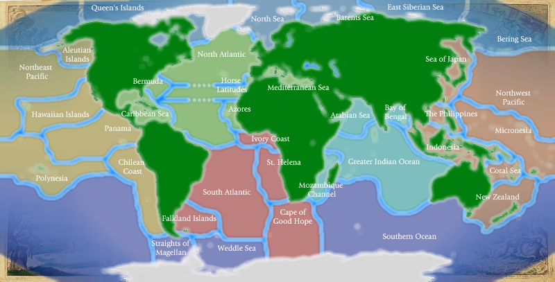
For reference purposes, N. Atlantic goes through the horse latitudes. Bering Sea, Southern Ocean, etc. go across map in case you hadn't guessed. Arctic ocean territories can all attack each other. As for the southern ocean, it touches 7 territories and so will be very important in a game.

Tentative Bonuses-
4 east pacific
3 antarctic (antarctic is the southern one)
3 south atlantic
3 north atlantic
2 indian
4 west pacific
3 arctic

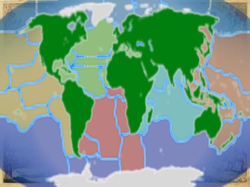
Because of the low values for all the bonuses, I am considering combining North & South Atlantic into one bonus with a bonus of 5 or 6.
I could do the same with the pacific for a bonus of 7 or 8.

So, using these bonuses, we would get this...

Possible Bonuses-
8 pacific
6 atlantic
2 indian
3 antarctic
3 arctic

But if I give Cape of Good Hope to antarctic, than it would be...

8 pacific
5 atlantic
2 indian
4 antarctic
3 arctic

This way has a better distribution of points, but I liked the fast paced gameplay that would be caused by having a ton of small bonuses.

Due to possible size concerns, here is a larger map. I may be able to do some more things with it now, as long as you can't tell it's stretched.

Image

If you have any comments regarding the bonuses, the territories, the names, or the graphics, please post. Feedback is very welcome.
Last edited by Aspect on Wed Dec 12, 2007 5:54 pm, edited 11 times in total.
User avatar
Corporal 1st Class Aspect
 
Posts: 36
Joined: Thu Jan 18, 2007 6:21 pm
Location: Seattle, WA

Postby Phil1580 on Wed Nov 28, 2007 1:02 am

A few other ideas are in these forums for this, but I think it's a great idea. With some beautification, I'd play it. :)
User avatar
Sergeant Phil1580
 
Posts: 103
Joined: Fri Oct 26, 2007 3:00 am
Location: New Englander in the land of Dixie.

Postby Coleman on Wed Nov 28, 2007 1:56 am

I don't like the white being used for both island formations and inland water. :(
User avatar
Sergeant Coleman
 
Posts: 5402
Joined: Tue Jan 02, 2007 10:36 pm
Location: Midwest

Postby Balsiefen on Wed Nov 28, 2007 6:23 am

Someone made a really good map of this burt he dropped it. it'll be somwhare in the foundry.
User avatar
Sergeant 1st Class Balsiefen
 
Posts: 2299
Joined: Wed Aug 30, 2006 6:15 am
Location: The Ford of the Aldar in the East of the Kingdom of Lindissi

map

Postby WL_southerner on Wed Nov 28, 2007 7:28 am

nice map like some of the made up names too
just an idea lo what if you named the seven seas ;- atlantic , medatran,pacific,caribbean,indian,southern,arctic has your continants then sub divsion each one like ie german bright, icelantic,dover,white,portland ect just to name a few thats around british waters
if you look on the royal admiralty navy charts you should find all the worlds local waters names,you be able to pick and chose whitch ones you use
friends :- come and go _ i have loads of them
mates :- go and come back_only have a few
Leatsa, dh'fhàgainnsa...
User avatar
Corporal WL_southerner
 
Posts: 314
Joined: Wed Mar 08, 2006 7:25 pm
Location: friends :- come and go _ i have loads of them

Postby duday53 on Wed Nov 28, 2007 8:20 am

I thought about making a map....and then found out that windows paint is very good.


But I would play it.


edit: Put seas in and say that if you own 3 you get +3
4 you get +4
5 you get +5
6 you get +6
Own all 7 and you get +7


Bonusses for that would need to be looked at. I'm not good at bonusses
lalaland wrote:This is what I love about Spamalot... you click on a title to a thread, and you have no idea what you'll find inside...
User avatar
Sergeant 1st Class duday53
 
Posts: 3046
Joined: Thu Mar 08, 2007 6:57 pm
Location: 1 hour north of Toronto, Ontario.

Postby oaktown on Wed Nov 28, 2007 9:12 am

this idea is picked up by somebody new every month! :)

http://www.conquerclub.com/forum/viewtopic.php?t=12132
Image
User avatar
Captain oaktown
 
Posts: 4451
Joined: Sun Dec 03, 2006 9:24 pm
Location: majorcommand

Postby Aspect on Wed Nov 28, 2007 5:41 pm

edit: Put seas in and say that if you own 3 you get +3
4 you get +4
5 you get +5
6 you get +6
Own all 7 and you get +7


I was going to have something like that, but I dropped it for this version because I used seas as part of the oceans... the arctic would have like 2 territories without the seas.
But the mediteranean black and red seas all work well together with the mediteranean connected to the red with suez canal

edit:
by the way, I posted this Idea like 6 months ago just to get it out there, I guess I didn't need to
User avatar
Corporal 1st Class Aspect
 
Posts: 36
Joined: Thu Jan 18, 2007 6:21 pm
Location: Seattle, WA

Postby Aspect on Tue Dec 11, 2007 8:19 pm

t-money bumphizorz
User avatar
Corporal 1st Class Aspect
 
Posts: 36
Joined: Thu Jan 18, 2007 6:21 pm
Location: Seattle, WA

Postby Tyr on Tue Dec 11, 2007 8:27 pm

what about adding canals in?
most people who want to share their veiws with you dont want you to share yours with them
Cadet Tyr
 
Posts: 405
Joined: Tue May 29, 2007 6:13 pm
Location: Mars

Postby Aspect on Wed Dec 12, 2007 12:32 am

Tyr wrote:what about adding canals in?


do you mean adding canals as territories, or as borders?
adding as territories is not a bad idea
but I don't think the thing I'm missing is more borders, if that is what you mean. Maybe if my map was larger I could fit more into it... though the only thing small about it is it's height.
i'll look into resizing it
User avatar
Corporal 1st Class Aspect
 
Posts: 36
Joined: Thu Jan 18, 2007 6:21 pm
Location: Seattle, WA

Postby oaktown on Wed Dec 12, 2007 1:49 am

if you're serious about making this happen - and I'm all for it because I have always supported this idea :D - you really should look through the previous attempts at this map. Viscount Gort made a lot of progress on this map, and taking advantage of the lessons learned there may save you a lot of changes later.

http://www.conquerclub.com/forum/viewtopic.php?t=12132
http://www.conquerclub.com/forum/viewtopic.php?t=1073
Image
User avatar
Captain oaktown
 
Posts: 4451
Joined: Sun Dec 03, 2006 9:24 pm
Location: majorcommand

Postby Coleman on Wed Dec 12, 2007 2:29 am

Which map is better?
The one with all the blue.
11% [ 1 ]
The one that has the grey space too, I like land!
11% [ 1 ]
I think you should stop altogether n00b.
22% [ 2 ]
I think that there should be land, but make it green and pretty!
55% [ 5 ]
Total Votes : 9
User avatar
Sergeant Coleman
 
Posts: 5402
Joined: Tue Jan 02, 2007 10:36 pm
Location: Midwest

Re: map

Postby Chirondom on Wed Dec 12, 2007 7:39 am

WL_southerner wrote:nice map like some of the made up names too
just an idea lo what if you named the seven seas ;- atlantic , medatran,pacific,caribbean,indian,southern,arctic has your continants then sub divsion each one like ie german bright, icelantic,dover,white,portland ect just to name a few thats around british waters
if you look on the royal admiralty navy charts you should find all the worlds local waters names,you be able to pick and chose whitch ones you use
The Seven Seas does not refer to that. It is a very specific reference dating back to the days of the Barbary pirates, meaning the 7 seas the Mediterrean world could reach.
Corporal Chirondom
 
Posts: 77
Joined: Wed Jul 04, 2007 5:51 pm


Return to Melting Pot: Map Ideas

Who is online

Users browsing this forum: No registered users