My concern is not about the size, simply about whether or not this is a map or just an image with some stuff on top to make it a map.
Are of the land: 160279
Area of image: 671997
24%... okay. 3 out of 4 pixels on the image are not part of the map. Thanks.
sunrise in Paradise.
Moderator: Cartographers
Re: Jamaica
![]() by The Neon Peon on Sun Oct 25, 2009 9:51 pm
by The Neon Peon on Sun Oct 25, 2009 9:51 pm
-

 The Neon Peon
- Posts: 2342
- Joined: Sat Jun 14, 2008 12:49 pm


Re: Jamaica
![]() by porkenbeans on Sun Oct 25, 2009 10:15 pm
by porkenbeans on Sun Oct 25, 2009 10:15 pm
OK knucklehead, Here is where I show you, just how smart you really are.The Neon Peon wrote:My concern is not about the size, simply about whether or not this is a map or just an image with some stuff on top to make it a map.
Are of the land: 160279
Area of image: 671997
24%... okay. 3 out of 4 pixels on the image are not part of the map. Thanks.
Your calculations are only taking into account the land area. If you run these same calculations on any other map with oceans and such you will get a similar result. Try it with World 2.1, or a closer example, like the new Japan map, by Red Barron.
As I stated before, the shape of the island pretty much dictates the size of the map. I even had to tilt the map so that the north is facing 2 o'clock, to get the largest image into the space.
I know that you are trying to find ways to bash this project, but maybe you could think of something more intelligent to say. We are working fast and furious here, and while we do appreciate any thoughtful suggestions, your mindless jabs are NOT welcomed.

-

porkenbeans
- Posts: 2546
- Joined: Mon Sep 10, 2007 4:06 pm


Re: Jamaica
![]() by The Neon Peon on Sun Oct 25, 2009 10:36 pm
by The Neon Peon on Sun Oct 25, 2009 10:36 pm
porken, why do you take any criticism of something you've done as an assault against you personally? Just chill, and actually think that perhaps the person has a legitimate reason behind what they are saying.
I am simply saying that this does not look much like a map. I had something similar with the Ukraine map, where I focused more on making it look good than making it look like a map. When I changed it, I had a lot more comments on it and several people first commented that they liked the graphics.
What is thoughtless about saying there is a lot of wasted space on the map? Let me show you what I mean: Crop out the blue space, everything else can still fit in.
Original Area: 671997
New Area: 426662
Old percentage of space used: 24%
New percentage of space used: 38%
I am simply saying that this does not look much like a map. I had something similar with the Ukraine map, where I focused more on making it look good than making it look like a map. When I changed it, I had a lot more comments on it and several people first commented that they liked the graphics.
What is thoughtless about saying there is a lot of wasted space on the map? Let me show you what I mean: Crop out the blue space, everything else can still fit in.
- Click image to enlarge.

Original Area: 671997
New Area: 426662
Old percentage of space used: 24%
New percentage of space used: 38%
-
The Neon Peon
- Posts: 2342
- Joined: Sat Jun 14, 2008 12:49 pm
Re: Jamaica
![]() by porkenbeans on Sun Oct 25, 2009 10:53 pm
by porkenbeans on Sun Oct 25, 2009 10:53 pm
Because you are very often just blowing smoke. Like you are here. What about all the maps with the elaborate scrawly borders. Would you have them chop it out ?
My scrawly borders just happens to be the Caribbean sea. Jamaica is all about the Caribbean. I want the feel of this map to reflect that. And like I said before, this map is similar in this respect to other CC maps. I think that what is giving you this unwarranted perception is the fact that the land is the same color as the sea and sky, that it borders. Look at the 1st. version, and you will see what I mean.
For the record, I do NOT take any criticism as an attack. On the contrary, I welcome and hope for criticism that helps me. You my friend are just plain crazy if you think your chop job is in that category.
If there is a universal call for me to reduce the size, I can probably move the bottom up a bit, but nothing anywhere as much as you suggest.
Last edited by porkenbeans on Sun Oct 25, 2009 11:07 pm, edited 1 time in total.
-
porkenbeans
- Posts: 2546
- Joined: Mon Sep 10, 2007 4:06 pm
Re: Jamaica
![]() by The Neon Peon on Sun Oct 25, 2009 11:06 pm
by The Neon Peon on Sun Oct 25, 2009 11:06 pm
porkenbeans wrote:My scrawly borders just happens to be the Caribbean sea. Jamaica is all about the Caribbean. I want the feel of this map to reflect that. And like I said before, this map is similar in this respect to other CC maps. I think that what is giving you this unwarranted perception is the fact that the land is the same color as the sea and sky, that it borders. Look at the 1st. version, and you will see what I mean.
Thank you for being intelligent and providing a response. Thank you for realizing that I was providing a suggestion to make it look better. Thank you for explaining why the map looks like it is.
I'm satisfied. I was simply wondering about whether you you were simply trying to fill up all the space with the image in the background since it was distracting me away from the map.
porkenbeans wrote:Because you are very often just blowing smoke. Like you are here. What about all the maps with the elaborate scrawly borders. Would you have them chop it out ?
Is there any need for that? I don't comment often on maps at all, yet I spend 96% of my time on CC reading threads in the foundry. I only comment if I actually have something meaningful to say. Please, next time provide an explanation, then, if I just ignore it and keep screaming for you to get rid of the space, start insulting me.
-
The Neon Peon
- Posts: 2342
- Joined: Sat Jun 14, 2008 12:49 pm
Re: Jamaica
![]() by Raskholnikov on Sun Oct 25, 2009 11:30 pm
by Raskholnikov on Sun Oct 25, 2009 11:30 pm
See? That is helpful: constructive criticism. Should have said so from the beginning instead of seeming to just put down the entire project.
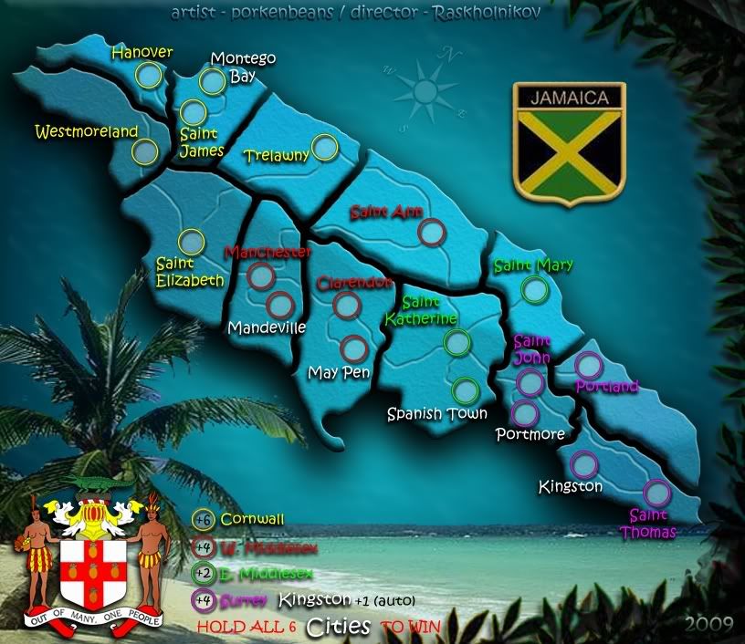
Porkenbeans, here is my new draft based on your last. Please adapt this to your version.

Because you wanted to place cities and roads, and because we had to add a few cities anyway to make it really playable, I suggest we use the names of the Capitals of each parrish, not the names of the parrishes themselves. This also allows our roads to be pretty much real and gives the entire thing consistency (all cities, not a mix of cities and parrishes).
I re-calculated the bonuses based on cities, not parrishes.
Hope you like it.
Btw you may wish to use Jamaica's coat of arms too if space is available.. lol
http://upload.wikimedia.org/wikipedia/c ... ca.svg.png
Porkenbeans, here is my new draft based on your last. Please adapt this to your version.
Because you wanted to place cities and roads, and because we had to add a few cities anyway to make it really playable, I suggest we use the names of the Capitals of each parrish, not the names of the parrishes themselves. This also allows our roads to be pretty much real and gives the entire thing consistency (all cities, not a mix of cities and parrishes).
I re-calculated the bonuses based on cities, not parrishes.
Hope you like it.
Btw you may wish to use Jamaica's coat of arms too if space is available.. lol
http://upload.wikimedia.org/wikipedia/c ... ca.svg.png
-

Raskholnikov
- Posts: 638
- Joined: Fri Sep 11, 2009 3:40 pm


Re: Jamaica
![]() by porkenbeans on Sun Oct 25, 2009 11:40 pm
by porkenbeans on Sun Oct 25, 2009 11:40 pm
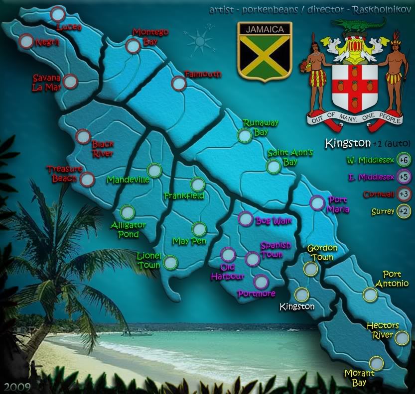
- Click image to enlarge.
Here it is chopped and squished. I will let there be a vote on it. I will go for it if it IS the preference, although I personally think it looses some of the open and free feel that Jamaica is know for.
Last edited by porkenbeans on Mon Oct 26, 2009 12:16 am, edited 2 times in total.
-
porkenbeans
- Posts: 2546
- Joined: Mon Sep 10, 2007 4:06 pm
Re: Jamaica
![]() by isaiah40 on Mon Oct 26, 2009 12:01 am
by isaiah40 on Mon Oct 26, 2009 12:01 am
Hmmm ... I think you should swap the Cornwall and W. Middlesex bonuses around. Cornwall only has 2 defending against 2. While W. Middlesex is in the middle so I feel that it should have a higher bonus. Also you have a bottle neck in Saint John as it is the only way in and out of Surrey. Maybe add in a couple more cities and roads connecting Surrey with E. Middlesex. Also I noticed that it probably be way too easy to hold all cities and win as all the cities are dead ends. Hold the adjacent parishes and you can hold the cities, especially the cities in Surrey with the bottle neck.
-
isaiah40
- Posts: 3990
- Joined: Mon Aug 27, 2007 7:14 pm


Re: Jamaica
![]() by Raskholnikov on Mon Oct 26, 2009 12:10 am
by Raskholnikov on Mon Oct 26, 2009 12:10 am
Hi Isaiah,
Thanks for your comments. Porks map was in no way definite in terms of bonuses, cities, or road connections. Please check my draft posted just above your comments and you will note it anticipated all your sugggestions.
Thanks,
Raskholnikov
Thanks for your comments. Porks map was in no way definite in terms of bonuses, cities, or road connections. Please check my draft posted just above your comments and you will note it anticipated all your sugggestions.
Thanks,
Raskholnikov
-
Raskholnikov
- Posts: 638
- Joined: Fri Sep 11, 2009 3:40 pm
Re: Jamaica
![]() by porkenbeans on Mon Oct 26, 2009 12:22 am
by porkenbeans on Mon Oct 26, 2009 12:22 am
OK, so I will work from the un-chopped version 4 in next update, unless you think that the chopped version is the way to go.
Also Rask, keep in mind that this map was given the go because it was different from cairns Jam. map. in that it is smaller with less territs. I like the 24 territ count. I think that will work out just right. I will try to have version 5 up soon.
Also Rask, keep in mind that this map was given the go because it was different from cairns Jam. map. in that it is smaller with less territs. I like the 24 territ count. I think that will work out just right. I will try to have version 5 up soon.
-
porkenbeans
- Posts: 2546
- Joined: Mon Sep 10, 2007 4:06 pm
Re: Jamaica
![]() by Raskholnikov on Mon Oct 26, 2009 1:35 am
by Raskholnikov on Mon Oct 26, 2009 1:35 am
Perfect. I agree 24 is max. But as you say, it will work out nice and still be different from the more complex game-play of the Cairns map.
I agree with the un-chopped idea. I'd still keep the parrish boundaries though... Up to you though to see what works..
Can't wait for the next version! TTYL
I agree with the un-chopped idea. I'd still keep the parrish boundaries though... Up to you though to see what works..
Can't wait for the next version! TTYL
-
Raskholnikov
- Posts: 638
- Joined: Fri Sep 11, 2009 3:40 pm
Re: Jamaica
![]() by porkenbeans on Wed Oct 28, 2009 2:02 am
by porkenbeans on Wed Oct 28, 2009 2:02 am
- Click image to enlarge.

OK, I had to do some major overhauls because of the added territs.
It looks like peon at least will be happy.
Truth be known, I am also.
Looking forward to feedback.
Last edited by porkenbeans on Fri Oct 30, 2009 4:30 pm, edited 1 time in total.
-
porkenbeans
- Posts: 2546
- Joined: Mon Sep 10, 2007 4:06 pm
Re: Jamaica
![]() by Raskholnikov on Wed Oct 28, 2009 2:08 am
by Raskholnikov on Wed Oct 28, 2009 2:08 am
wow! love it! My only suggestion would be to add the names of the regions in the bonus area (cornwall, west middlesex, east middlesex, surrey). Otherwise, amazing work! I think this would be a fun map to play on!
-
Raskholnikov
- Posts: 638
- Joined: Fri Sep 11, 2009 3:40 pm
Re: Jamaica
![]() by porkenbeans on Wed Oct 28, 2009 2:20 am
by porkenbeans on Wed Oct 28, 2009 2:20 am
Oh yeah, forgot to add them.Raskholnikov wrote:wow! love it! My only suggestion would be to add the names of the regions in the bonus area (cornwall, west middlesex, east middlesex, surrey). Otherwise, amazing work! I think this would be a fun map to play on!
BTW, did you notice the turtle ?
-
porkenbeans
- Posts: 2546
- Joined: Mon Sep 10, 2007 4:06 pm
Re: Jamaica
![]() by porkenbeans on Wed Oct 28, 2009 3:00 am
by porkenbeans on Wed Oct 28, 2009 3:00 am
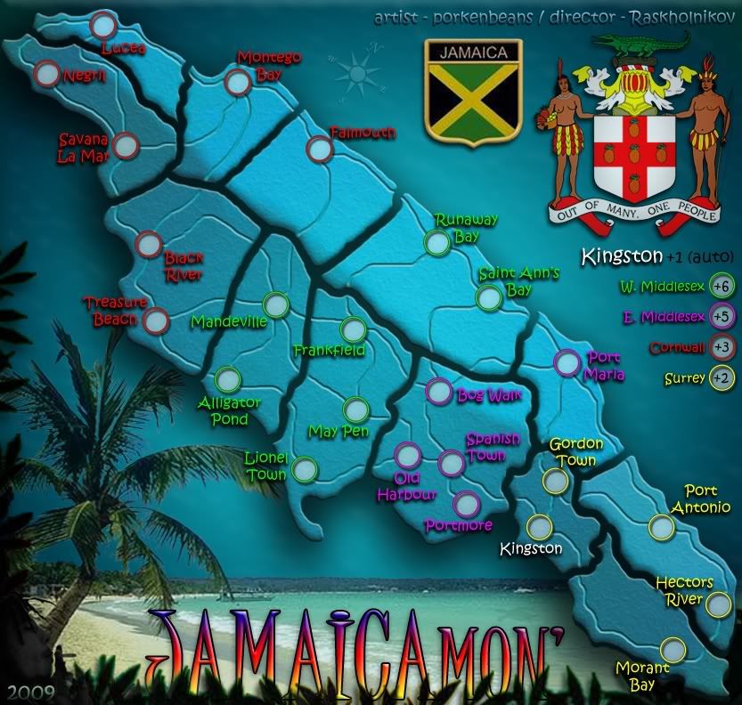
This image was perfect when I posted it now it has become blurred. WTF is going on ? This has happened 3 times in the last couple of days. It's like someone has hacked my photobucket account and sabotaged my files. version 6
- Click image to enlarge.
Last edited by porkenbeans on Fri Oct 30, 2009 9:57 pm, edited 1 time in total.
-
porkenbeans
- Posts: 2546
- Joined: Mon Sep 10, 2007 4:06 pm
Re: Jamaica
![]() by Raskholnikov on Wed Oct 28, 2009 3:34 am
by Raskholnikov on Wed Oct 28, 2009 3:34 am
LOL yes (s)he's sweet.... Map looks good now  Let's see what the Foundry gods will say
Oh btw... what's our map's title? lol
Jamaica Surf 'n Turf maybe? lol
Oh btw... what's our map's title? lol
Jamaica Surf 'n Turf maybe? lol
-
Raskholnikov
- Posts: 638
- Joined: Fri Sep 11, 2009 3:40 pm
Re: Jamaica
![]() by porkenbeans on Wed Oct 28, 2009 4:19 am
by porkenbeans on Wed Oct 28, 2009 4:19 am
How about JAMAICAMON'. 
- Click image to enlarge.
Last edited by porkenbeans on Thu Oct 29, 2009 9:47 pm, edited 1 time in total.
-
porkenbeans
- Posts: 2546
- Joined: Mon Sep 10, 2007 4:06 pm
Re: JAMAICAmon' new map
![]() by porkenbeans on Wed Oct 28, 2009 3:02 pm
by porkenbeans on Wed Oct 28, 2009 3:02 pm
Note to the Foundry; Please let me know if there is something more that I need to do, to get this thing moved up to the next step in the process. Thanx.
Any and all feedback, from any and all viewers, ...is very welcomed.
Any and all feedback, from any and all viewers, ...is very welcomed.
-
porkenbeans
- Posts: 2546
- Joined: Mon Sep 10, 2007 4:06 pm
Re: Jamaica
![]() by RedBaron0 on Wed Oct 28, 2009 3:14 pm
by RedBaron0 on Wed Oct 28, 2009 3:14 pm
The only question I have at this point is: Why does the island need to be divided into sections? Might be best to take out the black lines dividing the island and lets see it as just a single land mass.


-

RedBaron0
- Posts: 2657
- Joined: Sun Aug 19, 2007 12:59 pm
- Location: Pennsylvania


Re: JAMAICAmon' new map
![]() by isaiah40 on Wed Oct 28, 2009 3:17 pm
by isaiah40 on Wed Oct 28, 2009 3:17 pm
porkenbeans wrote:Note to the Foundry; Please let me know if there is something more that I need to do, to get this thing moved up to the next step in the process. Thanx.
Any and all feedback, from any and all viewers, ...is very welcomed.
How about take out that extra border with that guy smoking? I liked the background when it was unincumbered.
-
isaiah40
- Posts: 3990
- Joined: Mon Aug 27, 2007 7:14 pm
Re: JAMAICAmon' new map
![]() by porkenbeans on Wed Oct 28, 2009 4:59 pm
by porkenbeans on Wed Oct 28, 2009 4:59 pm
Bob Marley has been there since the first draft. He was the first thing that I thought of, when deciding what kind of style and feel that I was after. Yeah mon' doncha know ?isaiah40 wrote:porkenbeans wrote:Note to the Foundry; Please let me know if there is something more that I need to do, to get this thing moved up to the next step in the process. Thanx.
Any and all feedback, from any and all viewers, ...is very welcomed.
How about take out that extra border with that guy smoking? I liked the background when it was unincumbered.
-
porkenbeans
- Posts: 2546
- Joined: Mon Sep 10, 2007 4:06 pm
Re: Jamaica
![]() by porkenbeans on Wed Oct 28, 2009 5:18 pm
by porkenbeans on Wed Oct 28, 2009 5:18 pm
If I did that Red, it would be just like all the other maps. Besides there IS a reason for the lines. They denote the various parish regions that is Jamaica today. And it is in the best interests of this map, as it helps to distinguish it from cairn's Jam. map.RedBaron0 wrote:The only question I have at this point is: Why does the island need to be divided into sections? Might be best to take out the black lines dividing the island and lets see it as just a single land mass.
-
porkenbeans
- Posts: 2546
- Joined: Mon Sep 10, 2007 4:06 pm
Re: Jamaica
![]() by Raskholnikov on Wed Oct 28, 2009 6:16 pm
by Raskholnikov on Wed Oct 28, 2009 6:16 pm
The divisions represent the 14 (13 plus Kingston) island Parrishes). It gives the player a better feel for the administrative division of the island as well as for the composition of each of the island regions (Cornwall, Surrey, Middlesex - last of which had to be dubdivided in East and West for game purposes. We could add on faded letters as background the name of each parrish if you think that would help. Most cities in play are capitals of the parrishes.
-
Raskholnikov
- Posts: 638
- Joined: Fri Sep 11, 2009 3:40 pm
Re: Jamaica
![]() by Raskholnikov on Wed Oct 28, 2009 6:39 pm
by Raskholnikov on Wed Oct 28, 2009 6:39 pm
pork,
Any chance of including the geographical features - ie mountains and rivers - like you did for the Romania map, but only in shades of blue, like the Scandinavia map you liked, and then change the color of the roads to maybe black ? Idk just an idea I got after I read your positive comments on the texture of the Scandinavia map.
Any chance of including the geographical features - ie mountains and rivers - like you did for the Romania map, but only in shades of blue, like the Scandinavia map you liked, and then change the color of the roads to maybe black ? Idk just an idea I got after I read your positive comments on the texture of the Scandinavia map.
-
Raskholnikov
- Posts: 638
- Joined: Fri Sep 11, 2009 3:40 pm
Return to Melting Pot: Map Ideas
Who is online
Users browsing this forum: No registered users
|
|||||||
| Conquer Club is not associated with RISK online in any way. Copyright © 2006-2025 by Big Wham LLC | |||||||