Well, with this map it is a bit different. This map is very stylized. From the color, to the floating in the sky, To the carefree font, to the empty space in place of borders. If we tried geographical features as you suggest, it would clash with the style. It would also tend to over work the piece, from an artistic point of view.Raskholnikov wrote:pork,
Any chance of including the geographical features - ie mountains and rivers - like you did for the Romania map, but only in shades of blue, like the Scandinavia map you liked, and then change the color of the roads to maybe black ? Idk just an idea I got after I read your positive comments on the texture of the Scandinavia map.
sunrise in Paradise.
Moderator: Cartographers
Re: Jamaica
![]() by porkenbeans on Wed Oct 28, 2009 11:01 pm
by porkenbeans on Wed Oct 28, 2009 11:01 pm

-

 porkenbeans
- Posts: 2546
- Joined: Mon Sep 10, 2007 4:06 pm


Re: Jamaica
![]() by RedBaron0 on Wed Oct 28, 2009 11:13 pm
by RedBaron0 on Wed Oct 28, 2009 11:13 pm
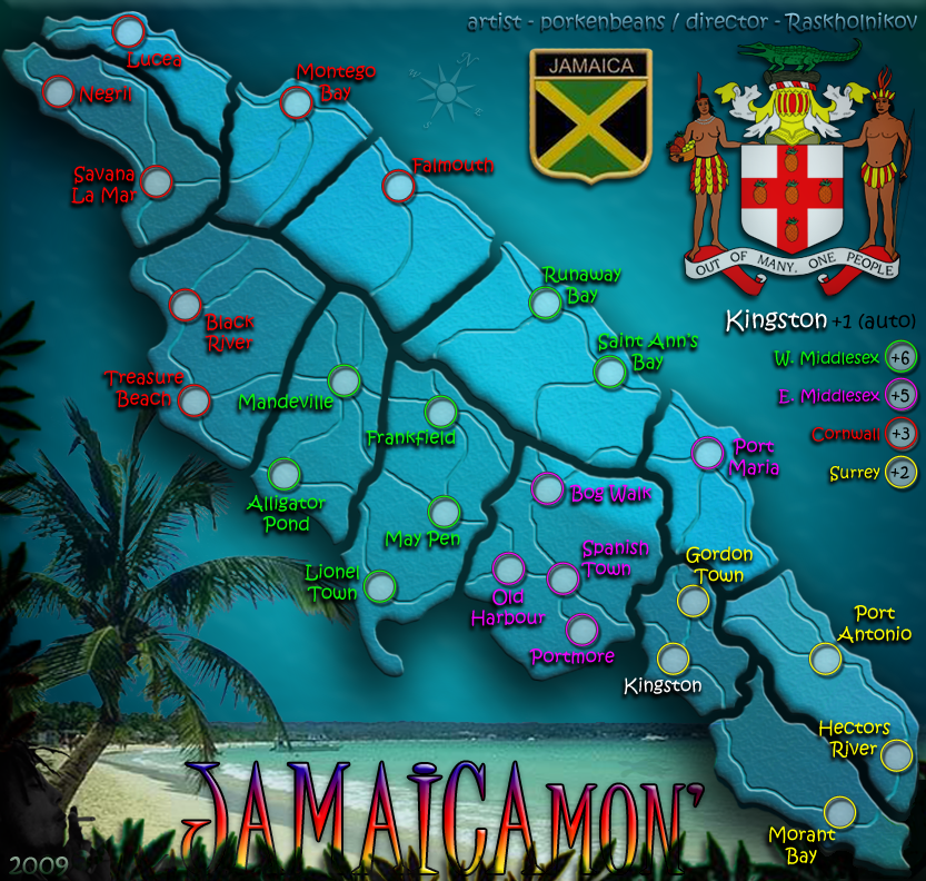
porkenbeans wrote:If I did that Red, it would be just like all the other maps. Besides there IS a reason for the lines. They denote the various parish regions that is Jamaica today. And it is in the best interests of this map, as it helps to distinguish it from cairn's Jam. map.RedBaron0 wrote:The only question I have at this point is: Why does the island need to be divided into sections? Might be best to take out the black lines dividing the island and lets see it as just a single land mass.
Alright I understand that now, but be careful that the lines that are connecting territories are being cut off. This my cause confusion to where territories connect. Perhaps try make the black line a bit thinner. Other than that you could connect the territory connection lines across the black gaps, but I don't think that would look very good.


-

RedBaron0
- Posts: 2657
- Joined: Sun Aug 19, 2007 12:59 pm
- Location: Pennsylvania


Re: Jamaica
![]() by porkenbeans on Wed Oct 28, 2009 11:19 pm
by porkenbeans on Wed Oct 28, 2009 11:19 pm
Red are you confused about any particular connections ? I think all the connections are pretty clear.RedBaron0 wrote:porkenbeans wrote:If I did that Red, it would be just like all the other maps. Besides there IS a reason for the lines. They denote the various parish regions that is Jamaica today. And it is in the best interests of this map, as it helps to distinguish it from cairn's Jam. map.RedBaron0 wrote:The only question I have at this point is: Why does the island need to be divided into sections? Might be best to take out the black lines dividing the island and lets see it as just a single land mass.
Alright I understand that now, but be careful that the lines that are connecting territories are being cut off. This my cause confusion to where territories connect. Perhaps try make the black line a bit thinner. Other than that you could connect the territory connection lines across the black gaps, but I don't think that would look very good.
-
porkenbeans
- Posts: 2546
- Joined: Mon Sep 10, 2007 4:06 pm
Re: Jamaica
![]() by porkenbeans on Wed Oct 28, 2009 11:32 pm
by porkenbeans on Wed Oct 28, 2009 11:32 pm
Not a problem. I would rather here an idea that I don't care for, than to have no ideas offered at all.Raskholnikov wrote:ok. was just a thought
-
porkenbeans
- Posts: 2546
- Joined: Mon Sep 10, 2007 4:06 pm
Re: Jamaica
![]() by RedBaron0 on Wed Oct 28, 2009 11:54 pm
by RedBaron0 on Wed Oct 28, 2009 11:54 pm
porkenbeans wrote:Red are you confused about any particular connections ? I think all the connections are pretty clear.
](./images/smilies/eusa_wall.gif "Brick wall")
-
RedBaron0
- Posts: 2657
- Joined: Sun Aug 19, 2007 12:59 pm
- Location: Pennsylvania
Re: Jamaica
![]() by porkenbeans on Thu Oct 29, 2009 9:46 pm
by porkenbeans on Thu Oct 29, 2009 9:46 pm
OK,
this he the second time this has happened to me. I uploaded to photobucket and then copied the link to here. the image was fine. Then a day or two later it is all blurry. Lets try this again.
edit. seems fine now. I relinked the last image post as well.
this he the second time this has happened to me. I uploaded to photobucket and then copied the link to here. the image was fine. Then a day or two later it is all blurry. Lets try this again.
edit. seems fine now. I relinked the last image post as well.
- Click image to enlarge.

-
porkenbeans
- Posts: 2546
- Joined: Mon Sep 10, 2007 4:06 pm
Re: Jamaica
![]() by Gilligan on Fri Oct 30, 2009 5:50 am
by Gilligan on Fri Oct 30, 2009 5:50 am
Yeahhhhhh... top right hand corner probly won't work. 

-

Gilligan
- Posts: 12478
- Joined: Thu May 11, 2006 4:59 pm
- Location: Providence, RI


Re: Jamaica
![]() by RjBeals on Fri Oct 30, 2009 6:36 am
by RjBeals on Fri Oct 30, 2009 6:36 am
if you're not going to color the territories, why not give the map more of a satellite feel - like google earth?

-

RjBeals
- Posts: 2506
- Joined: Mon Nov 20, 2006 5:17 pm
- Location: South Carolina, USA


Re: Jamaica
![]() by porkenbeans on Fri Oct 30, 2009 12:56 pm
by porkenbeans on Fri Oct 30, 2009 12:56 pm
RJ,RjBeals wrote:if you're not going to color the territories, why not give the map more of a satellite feel - like google earth?
Glad to see you here, and thank you for the suggestion. That would certainly be one way to go, but with this map, I was trying to give the appearance of it just growing out from the sky and sea. That is why I chose not to give it much texture at all, and why I colored it the way that I did. I wanted all of the emphasis to be on the text and roads. Keeping it clean and simple as I could.
I like your maps very much, and I know very well, that you are a force that warrants consideration. I hope that you will understand, and appreciate, just where I am trying to go with this one.
-
porkenbeans
- Posts: 2546
- Joined: Mon Sep 10, 2007 4:06 pm
Re: Jamaica
![]() by WidowMakers on Fri Oct 30, 2009 1:27 pm
by WidowMakers on Fri Oct 30, 2009 1:27 pm
I have been reading through the thread but I may have missed it so please forgive me if I did.
I like the arm circles and your text. I just think you are trying to do to much in one map and it is getting crowded and confusing for no reason.
WM
P.S. I agree with RJ. Make a satellite map style with the same GP. It can still be a cartoony sat map but it will feel better and make more sense.
- 1) Why is the island broke up into pieces? It does not represent any bonus structure that i can see. What do they represent.
2) The roads seem bland. They seem to be just beveled lines.
3) The upper right graphic will not make the cut. If something cannot be in an avatar, I am sure it cannot be in a map.
4) There seems to be several different graphical themes competing on the map.
- A) The official Jamaica patch
b) Jamaica Mon' text
c) the upper right image
d) the map
e) the background
I like the arm circles and your text. I just think you are trying to do to much in one map and it is getting crowded and confusing for no reason.
WM
P.S. I agree with RJ. Make a satellite map style with the same GP. It can still be a cartoony sat map but it will feel better and make more sense.

-
WidowMakers
- Posts: 2774
- Joined: Mon Nov 20, 2006 9:25 am
- Location: Detroit, MI


Re: Jamaica
![]() by Raskholnikov on Fri Oct 30, 2009 1:42 pm
by Raskholnikov on Fri Oct 30, 2009 1:42 pm
Widow,
Thanks for your comments. To parapharase:
Trust in Porkbeans with all your heart and do not lean on your own understanding. In all your ways acknowledge Him, And He will make your paths straight.
Raskholnikov
Thanks for your comments. To parapharase:
Trust in Porkbeans with all your heart and do not lean on your own understanding. In all your ways acknowledge Him, And He will make your paths straight.
Raskholnikov
-

Raskholnikov
- Posts: 638
- Joined: Fri Sep 11, 2009 3:40 pm


Re: Jamaica
![]() by WidowMakers on Fri Oct 30, 2009 1:43 pm
by WidowMakers on Fri Oct 30, 2009 1:43 pm
So you are just going to ignore my questions?Raskholnikov wrote:Widow,
Thanks for your comments. To parapharase:
Trust in Porkbeans with all your heart and do not lean on your own understanding. In all your ways acknowledge Him, And He will make your paths straight.
Raskholnikov
But I guess that may be for the best. It is not like RJ and I know anything about this stuff.
WM
-
WidowMakers
- Posts: 2774
- Joined: Mon Nov 20, 2006 9:25 am
- Location: Detroit, MI
Re: Jamaica
![]() by Raskholnikov on Fri Oct 30, 2009 2:03 pm
by Raskholnikov on Fri Oct 30, 2009 2:03 pm
LOL That was a joke of course. One thinks you might have recognised your own Signature byline and not taken it seriously. Ah well.....
Yes we DO take your comments seriously.
Yes we WILL address them in detail.
Thank you for your input and sugggestions, based on your extensive experience with twenty CC maps.
Bows all the way down and exists backwards, eyes lowered to the ground.
Yes we DO take your comments seriously.
Yes we WILL address them in detail.
Thank you for your input and sugggestions, based on your extensive experience with twenty CC maps.
Bows all the way down and exists backwards, eyes lowered to the ground.
-
Raskholnikov
- Posts: 638
- Joined: Fri Sep 11, 2009 3:40 pm
Re: Jamaica
![]() by porkenbeans on Fri Oct 30, 2009 3:51 pm
by porkenbeans on Fri Oct 30, 2009 3:51 pm
lol.Raskholnikov wrote:LOL That was a joke of course. One thinks you might have recognised your own Signature byline and not taken it seriously. Ah well.....
Yes we DO take your comments seriously.
Yes we WILL address them in detail.
Thank you for your input and sugggestions, based on your extensive experience with twenty CC maps.
Bows all the way down and exists backwards, eyes lowered to the ground.
I understand exactly what you guys are trying to say, and I really do appreciate your interest.
That said, let me explain my envision, and the reasons for the items that you have mentioned.
1.) This has already been explained a few posts prior.
2.) Yes the roads ARE just a beveled line. And, this is an attempt to keep it simple. I want all of the emphasis on the text, and for the island to just set in the background. If I put heavy black lines for connections it would just clash with the whole concept.
3.) The upper right graphic IS the official seal of the sovereign country of Jamaica. I would hate to see the prudistic few among us that would object, cause it to be nixed. In my view Jamaica's seal is no more phonographic than the Coppertone logo, or many fine Master Pieces that you would find in any of the worlds National Museums. I anticipated that this may become an issue, and I am fine with whatever the CC lords decide on it.
4.) As for these items "fitting together", I could not disagree with you more. I believe that everything "fits", And congeals together to produce a style that is unique from anything else at CC. This IS my goal here. I am NOT trying to make this map similar in style to yours or anyone Else's great works of art. I think that you may be trying to judge it to your own style. That is like trying to judge Picasso against Rembrandt. Both are fine works, but in no way can they be judged by the others sense of style.
5.) I am very glad that you like something about it.
-
porkenbeans
- Posts: 2546
- Joined: Mon Sep 10, 2007 4:06 pm


Re: Jamaica
![]() by The Neon Peon on Sun Nov 01, 2009 4:50 pm
by The Neon Peon on Sun Nov 01, 2009 4:50 pm
I tend to agree with WM, but I don't think there needs to be much change done to the map: getting rid of either
a. The Jamaican coat of arms
b. The Flag of Jamaica with "Jamaica" written on top
I don't understand why both are on the map, and they do clutter it up.
Other than that, I'm not so much a fan of the "mon" in the title. Isn't is a bit stereotypical?
a. The Jamaican coat of arms
b. The Flag of Jamaica with "Jamaica" written on top
I don't understand why both are on the map, and they do clutter it up.
Other than that, I'm not so much a fan of the "mon" in the title. Isn't is a bit stereotypical?
-

The Neon Peon
- Posts: 2342
- Joined: Sat Jun 14, 2008 12:49 pm


Re: Jamaica
![]() by natty dread on Sun Nov 01, 2009 5:04 pm
by natty dread on Sun Nov 01, 2009 5:04 pm
It's a reference to Jamaican "language" as far as I can tell...
I think this thread should be moved down to the drafts section. This is clearly a working draft by now, and it would probably get more attention there.
I think this thread should be moved down to the drafts section. This is clearly a working draft by now, and it would probably get more attention there.

-

natty dread
- Posts: 12877
- Joined: Fri Feb 08, 2008 8:58 pm
- Location: just plain fucked


Re: Jamaica
![]() by porkenbeans on Sun Nov 01, 2009 7:12 pm
by porkenbeans on Sun Nov 01, 2009 7:12 pm
Yes, nododies has already told me he would move it on up. I am just having a problem with my pictures. Everything I upload to photobucket is coming out blurred. Initially it is fine, but then when I return a day or two later it is all messed up. maybe you have noticed this in all of my posts in other threads.natty_dread wrote:It's a reference to Jamaican "language" as far as I can tell...
I think this thread should be moved down to the drafts section. This is clearly a working draft by now, and it would probably get more attention there.
I have been given the OK on both this, and the Romania map, but I can't really do anything until I figure out what is going on with my pictures. If any of you wizards out there can clue me in on how I can fix this, I would be very, very grateful.
-
porkenbeans
- Posts: 2546
- Joined: Mon Sep 10, 2007 4:06 pm
Re: Jamaica
![]() by natty dread on Sun Nov 01, 2009 7:18 pm
by natty dread on Sun Nov 01, 2009 7:18 pm
Try using imageshack, I've never had problems hosting pictures on imageshack.
Also save your pictures as PNG:s. Maybe photobucket is trying to conserve space by recompressing your JPG:s? Just a guess...
Also save your pictures as PNG:s. Maybe photobucket is trying to conserve space by recompressing your JPG:s? Just a guess...
-
natty dread
- Posts: 12877
- Joined: Fri Feb 08, 2008 8:58 pm
- Location: just plain fucked
Re: Jamaica
![]() by porkenbeans on Sun Nov 01, 2009 7:57 pm
by porkenbeans on Sun Nov 01, 2009 7:57 pm
OK here is a png test. We will know if it works in a day or two. 
- Click image to enlarge.
-
porkenbeans
- Posts: 2546
- Joined: Mon Sep 10, 2007 4:06 pm
Re: Jamaica
![]() by Industrial Helix on Sun Nov 01, 2009 8:03 pm
by Industrial Helix on Sun Nov 01, 2009 8:03 pm
Cool ideas here... but I think I'm leaning in favor of something that's a bit smaller in terms of gameplay. I don't get why it has territory boundaries when the territories are connected city to city. One or the other would be preferable.
Sketchblog [Update 07/25/11]: http://indyhelixsketch.blogspot.com/
Living in Japan [Update 07/17/11]: http://mirrorcountryih.blogspot.com/
Russian Revolution map for ConquerClub [07/20/11]: viewtopic.php?f=241&t=116575
Living in Japan [Update 07/17/11]: http://mirrorcountryih.blogspot.com/
Russian Revolution map for ConquerClub [07/20/11]: viewtopic.php?f=241&t=116575
-

Industrial Helix
- Posts: 3462
- Joined: Mon Jul 14, 2008 6:49 pm
- Location: Ohio


Re: Jamaica
![]() by WidowMakers on Sun Nov 01, 2009 8:11 pm
by WidowMakers on Sun Nov 01, 2009 8:11 pm
Agreed. It is confusing.Industrial Helix wrote:Cool ideas here... but I think I'm leaning in favor of something that's a bit smaller in terms of gameplay. I don't get why it has territory boundaries when the territories are connected city to city. One or the other would be preferable.
Plus, the map is too big for only 24 territories. I say make is smaller and more manageable or fill in more area with more territories.
-
WidowMakers
- Posts: 2774
- Joined: Mon Nov 20, 2006 9:25 am
- Location: Detroit, MI
Re: Jamaica
![]() by natty dread on Sun Nov 01, 2009 8:15 pm
by natty dread on Sun Nov 01, 2009 8:15 pm
Yeah, a 800x800 size would be better for a small map like this. In fact, I think that's the maximum size recommendation for standard maps, the 840x800 size is supposedly only for maps that really need that size.
-
natty dread
- Posts: 12877
- Joined: Fri Feb 08, 2008 8:58 pm
- Location: just plain fucked
Re: Jamaica
![]() by porkenbeans on Mon Nov 02, 2009 12:15 am
by porkenbeans on Mon Nov 02, 2009 12:15 am
About the size. I am glad that it has been brought up. If you have noticed, all of my maps have large text, and large as possible territs. This IS for a reason. You see, there are quite a few of us CC goers that are not young. Us older in the tooth, really like maps that are not so difficult to read with tiny text, and itty-bitty territs. Our old eyes are just not up to the task, and it does quite often produce headaches when we play such maps.
It is true, I could make this map smaller, but I would need to make the text smaller as well. Which goes against the style of maps, that I want to make. So, look forward to seeing all of my maps with this style.
The puzzle like graphics, IE: the lines that separate the real to life parishes, are there as an attempt be true to the geography of Jamaica. Only the capitols of the parishes, plus a few of the other larger city's, are in the game play of this map. Rask has already done a pretty good job of explaining it. In any case, I quite frankly do NOT see how anyone could be confused as to the game play of this map. All of the city's are clearly labeled in large text, and are clearly connected by roads. It is as simple as Candy Land.
Besides, if the puzzle was put together, and the lines were removed, It would make for a pretty plain map. The way it is now adds interest, and I believe it is very striking.
-
porkenbeans
- Posts: 2546
- Joined: Mon Sep 10, 2007 4:06 pm
Return to Melting Pot: Map Ideas
Who is online
Users browsing this forum: No registered users
|
|||||||
| Conquer Club is not associated with RISK online in any way. Copyright © 2006-2025 by Big Wham LLC | |||||||