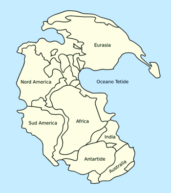
Pangaea Ultima [abandoned]
Moderator: Cartographers
![]() by Guiscard on Thu Mar 01, 2007 2:05 pm
by Guiscard on Thu Mar 01, 2007 2:05 pm
I'm assuming they're both based off of the same projection.
qwert wrote:Can i ask you something?What is porpose for you to open these Political topic in ConquerClub? Why you mix politic with Risk? Why you not open topic like HOT AND SEXY,or something like that.
-

 Guiscard
- Posts: 4103
- Joined: Fri Dec 08, 2006 7:27 pm
- Location: In the bar... With my head on the bar

![]() by AndyDufresne on Thu Mar 01, 2007 2:29 pm
by AndyDufresne on Thu Mar 01, 2007 2:29 pm
Their configuration is slightly different...I.E. some of the countries and mountains, etc.
--Andy
--Andy
-

AndyDufresne
- Posts: 24935
- Joined: Fri Mar 03, 2006 8:22 pm
- Location: A Banana Palm in Zihuatanejo


![]() by fluffybunnykins on Fri Mar 02, 2007 8:29 pm
by fluffybunnykins on Fri Mar 02, 2007 8:29 pm
It's interesting, I mean, any map that gives Madagascar it's very own bonus has got to be worth a go, eh?
I like the way the continents don't look so much like they're all hovering just above a giant ice cube, now... but, hey, in 250 million years, who knows...
I like the way the continents don't look so much like they're all hovering just above a giant ice cube, now... but, hey, in 250 million years, who knows...
Superman wears 'Fluffybunnykins' pyjamas
-

fluffybunnykins
- Posts: 385
- Joined: Tue May 02, 2006 6:43 am
- Location: Liverpool, UK

![]() by unriggable on Fri Mar 02, 2007 9:36 pm
by unriggable on Fri Mar 02, 2007 9:36 pm
Gabrioche wrote:I'm sorry unriggable but I can't change the continent configuration cause if I changed it, we could not anymore call it "Pangaea Ultima." Pangaea Ultima is the name given by Christopher Scotese to his potential configuration of the continents. However I still have to improve the connexions between the different countries. I will follow your advices.
To answer GreecePwns... Yes, the territories will have names. But I don't know yet how I'm gonna name them.
Touche. In that case carry on.
EDIT: What is in the classical game of risk known as Kamtchaka (the segment of russia closest to alaska) is part of the north american plate, so that would follow america.
-

unriggable
- Posts: 8037
- Joined: Thu Feb 08, 2007 9:49 pm
![]() by CitriC on Fri Mar 02, 2007 9:45 pm
by CitriC on Fri Mar 02, 2007 9:45 pm
the shape of africa and south america gives the idea that they were united and NOT the bottom of africa with the middle of north with south america..
i like the idea of the map not that part of the design ;(
i prefer like this http://www.vulkaneifel.de/eifel-vulkanmuseum/evm/assets/images/kont102.jpg
or
http://upload.wikimedia.org/wikipedia/commons/thumb/6/6f/Pangaea_italiano.png/350px-Pangaea_italiano.png
if it would be possible to change it would be 5 stars [/url]
oh and i think you should give like pre-historic names to the territories
i like the idea of the map not that part of the design ;(
i prefer like this http://www.vulkaneifel.de/eifel-vulkanmuseum/evm/assets/images/kont102.jpg
or
http://upload.wikimedia.org/wikipedia/commons/thumb/6/6f/Pangaea_italiano.png/350px-Pangaea_italiano.png
if it would be possible to change it would be 5 stars
oh and i think you should give like pre-historic names to the territories
-

CitriC
- Posts: 34
- Joined: Wed Jan 17, 2007 8:52 pm

![]() by sfhbballnut on Mon Mar 05, 2007 12:49 am
by sfhbballnut on Mon Mar 05, 2007 12:49 am
has this been abandoned, I was very interested before I left last week and it seems to have dropped off a bit
-
sfhbballnut
- Posts: 1687
- Joined: Fri May 05, 2006 3:01 pm


![]() by Kayla on Tue Mar 06, 2007 1:50 am
by Kayla on Tue Mar 06, 2007 1:50 am
sully800 wrote:I will say that you have the best 3D mountains of any map on this site- whether its up for play or just a draft. I really like the way they look.
So now we have 3 pangea maps in development? Though I guess you can't really count Kayla's- she spent days insulting Marv's map but hasn't realeased a single update on her own.
I have released updates. Oh and this map is looking freaking awesome. Im glad you didnt steal it from someone elses idea like (not saying names), but i think this looks completely awesome. Maybe you should also work on the past pangea, i have a long list of ideas to help you out with.
-

Kayla
- Posts: 409
- Joined: Wed Mar 01, 2006 2:43 am
- Location: Sedalia Missouri


![]() by unriggable on Sun Mar 11, 2007 11:21 am
by unriggable on Sun Mar 11, 2007 11:21 am
Gabrioche wrote:Don't worry sfhbballnut
I just didn't have the time to post news but I'm still working on the map.
Yea I really look forward to playing this map.
-
unriggable
- Posts: 8037
- Joined: Thu Feb 08, 2007 9:49 pm


![]() by Evil Pope on Sun Mar 11, 2007 3:57 pm
by Evil Pope on Sun Mar 11, 2007 3:57 pm
Wisse wrote:what did you update?
Well, its pretty obvious that he added names. And, maybe less obvious, an Antarctica-South america attack route. I think thats about it.
Edit: And also, he changed the color of water within the continents.. so they no long match the ocean; however, I think that it was much nicer when they matched.
-

Evil Pope
- Posts: 275
- Joined: Fri Jan 13, 2006 8:39 pm
![]() by Molacole on Sun Mar 11, 2007 4:28 pm
by Molacole on Sun Mar 11, 2007 4:28 pm
north america 3 border-10 territories = 3
oceana 3 borders-7 territories = 3
europe 3 borders-9 territories = 3
combine antartica&oceana 3 borders 12 territories = 5
madagascar&south america 4 borders 9 territories = 6
madagascar shouldn't be worth +2
I see the south turning out to be the deciding factor in this map. the southern bonuses are a breeze to hold and once you have both you're going to be very hard to stop if you go through south america.
asia should be worth 7
-

Molacole
- Posts: 552
- Joined: Fri Jun 23, 2006 8:19 am
- Location: W 2.0 map by ZIM


![]() by Bad Speler on Sun Mar 11, 2007 6:55 pm
by Bad Speler on Sun Mar 11, 2007 6:55 pm
Sorry if im being repetitive:
asia should be 8, 15 territories, 6 borders,
Europe perhaps a 4, it has 9 countries
Madagascar 1, as anyone who starts with it if it were to have a bonus of 2 would gain an immediate advantage.
North America also a 4
in my opinion, ths south is good how it is.
Africa and South America seems good.
I would like to take this oppurtunity to congratulate you on the graphics, some of the best ive seen so far.
Highest Score: 2532
Highest Position: 69 (a long time ago)
Highest Position: 69 (a long time ago)
-
Bad Speler
- Posts: 1027
- Joined: Fri Jun 02, 2006 8:16 pm
- Location: Ottawa


![]() by unriggable on Sun Mar 11, 2007 9:36 pm
by unriggable on Sun Mar 11, 2007 9:36 pm
Gabrioche wrote:Except the color of the seas and the bonus, what should be improved on my map?
I think madagascar should be part of africa, not it's own country. Being a dousche, I should say its not exactly to scale - shuld be smaller and closer to africa.
Also make the south america-asia mountains bigger.
-
unriggable
- Posts: 8037
- Joined: Thu Feb 08, 2007 9:49 pm
![]() by Enigma on Sun Mar 11, 2007 10:50 pm
by Enigma on Sun Mar 11, 2007 10:50 pm
agree w/ molacole-- south is way to easy to hold by far.
Do you need an excuse to have a war? I mean, who for? Can't you just say "You got lots of cash and land, but I've got a big sword, so divy up right now, chop chop."
Terry Pratchet
Terry Pratchet
-

Enigma
- Posts: 367
- Joined: Mon Jul 03, 2006 10:23 pm
- Location: Classified
![]() by Skittles! on Sun Mar 11, 2007 11:23 pm
by Skittles! on Sun Mar 11, 2007 11:23 pm
It's hard to see if Quebec and Angolia connect.
The graphics are looking sweet, The colours are looking really well done.
The graphics are looking sweet, The colours are looking really well done.
KraphtOne wrote:when you sign up a new account one of the check boxes should be "do you want to foe colton24 (it is highly recommended) "
-

Skittles!
- Posts: 14575
- Joined: Wed Jan 03, 2007 2:18 am

![]() by Ninja-Town on Sun Mar 11, 2007 11:47 pm
by Ninja-Town on Sun Mar 11, 2007 11:47 pm
Dude!! unlike some of the maps in the foundry, this is very very playable!!! I really really cant wait! GREAT MAP!
-

Ninja-Town
- Posts: 107
- Joined: Thu Jan 04, 2007 1:33 pm
Return to Melting Pot: Map Ideas
Who is online
Users browsing this forum: No registered users
|
|||||||
| Conquer Club is not associated with RISK online in any way. Copyright © 2006-2025 by Big Wham LLC | |||||||