get out of here
Moderator: Cartographers

Top Score:2403natty_dread wrote:I was wrong
How these colours now?TaCktiX wrote:The occasional darker color would be good, I agree.

Laci Mae...thanks for your post.laci_mae wrote:I love this map, and I'm super impressed with what you can accomplish in 2 weeks of map-making.
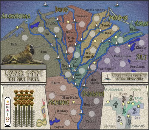
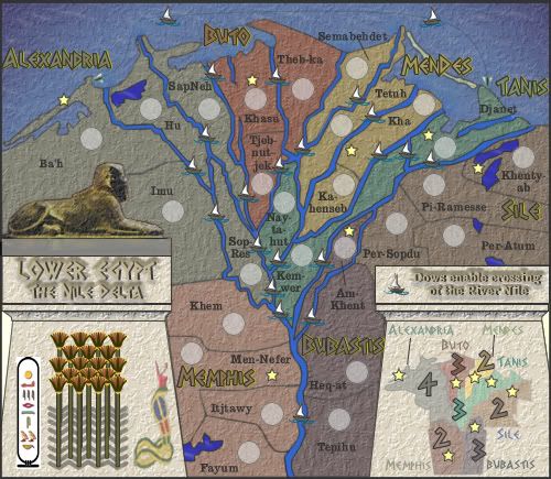
Question: I'm guessing the stars are the capitals, so is there some bonus related to them?
Minor graphic detail: The line from Am Khent (territory name) to the territory should be rotated clockwise a bit. It appears (at least at first glance) to point to the dow. It would be more clear if it pointed toward the army circle.
Best,
Laci
Thanks Gimil, that was fast !!!gimil wrote:
get out of here
I was thinking along these lines.cairnswk wrote:How these colours now?TaCktiX wrote:The occasional darker color would be good, I agree.

Thanks mibi, but may i ask why you chose the yellows and mustards.mibi wrote:cairnswk wrote:TaCktiX wrote:
I was thinking along these lines.
but its your map
Does:Ogrecrusher wrote:I agree with the yellows. They feel more deserty.

cairnswk wrote:How these colours now?TaCktiX wrote:The occasional darker color would be good, I agree.


Yes i agree it's a bit of both in stark contrast, however i am not making this as a representation of an overhead landscape shot from some satellite. You asked for the colours of Egypt, ad a darker less watery repsentation. These are colours that were used in ancient times.mibi wrote:In reality, its a bit of both sand and fertile land, in stark contrast.
I just don't know where all the blues and purples came from, I would love to see more realistic greens, and beiges.


it already has a plaster texture applied to it.Unit_2 wrote:Take the texture off the Syphix, because it looks like a part of the map.
yes it is already started on my computer hereKaplowitz wrote:Upper Egypt is next?

ok. taken on board, benny, i'll see what i can dobenny profane wrote:i very much like the way this is progressing, colors included.
my only suggestion is this:
maybe you'll consider varying the texture between the legend, land, and water?
the uniformity certainly doesn't ruin the map, but the rivers and lakes are the only things that stand out as distinct.
if you're going to distinguish the rivers and lakes, some further variation may help overall.

uh got you incandenza....see what i can come up with.Incandenza wrote:It's quite a nice-looking map. Should be entertaining to play on.
A couple small visual concerns:
could the Am-Khent terit name be moved closer to its army circle? I think you might be asking for trouble by having the per-sopdu name closer to the am-khent circle than the am-khent name is.
Also, the tjeb-nut-jek border with khasu doesn't stand out very well compared to the other borders. Perhaps the border and the khasu bits (name, circle, star) could be moved up a bit to give the t-n-j terit name and the northern border a bit of breathing room.
Thanks snufkin for your question.snufkin wrote:so my guess is that this is 10-15 % of Greek Egypt?
What century or centuries is it, and will upper egypt be from the same time?
looks pretty good!