
Welcome to the Foundry Proper... onwards and upwards
Mr B
Moderator: Cartographers

edbeard wrote:I'm just saying that the percentage of territories for land and sea respectively is about as far as I'm willing to go. If I added a few more land or took away a few sea territories then it would 'cross the line' for me

yeti_c wrote:edbeard wrote:I'm just saying that the percentage of territories for land and sea respectively is about as far as I'm willing to go. If I added a few more land or took away a few sea territories then it would 'cross the line' for me
You mean - that if you have to change it further then you'd drop it and move on?
C.
edbeard wrote:yeti_c wrote:edbeard wrote:I'm just saying that the percentage of territories for land and sea respectively is about as far as I'm willing to go. If I added a few more land or took away a few sea territories then it would 'cross the line' for me
You mean - that if you have to change it further then you'd drop it and move on?
C.
huh? I'm just saying that's as far as I'm going. It's my map why would I 'have to change it further'?

zimmah wrote:what about adding some large airports and/or ports and apply a bonus system for them. and in the case of airports, make them connect to each other.
might add some interesting gameplay.
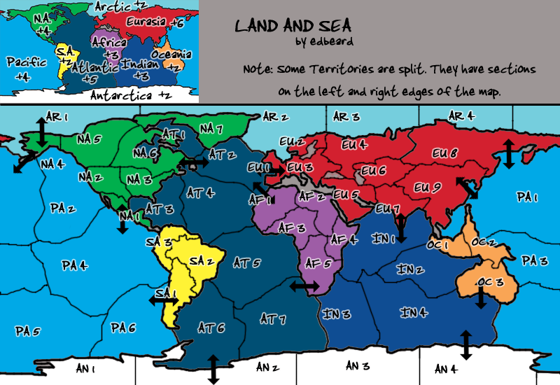
edbeard wrote:1. Atlantic. All four borders have 2 attackers. These come from 8 continents. EIGHT continents have one way to attack this continent. It's 7 territories and only a bonus of 5. Seemingly it'll be a central point because it borders basically everybody.
Should we remove some of these connections? (could remove both AT 4 connections and make AT 2 connect with NA 7 instead)
Should we increase it's bonus? (+6 or +7)
Should we leave it as it is?
edbeard wrote:2. In general, this map doesn't have very many 'hold both these continents together' routes. some people like these a lot. does it matter?
edbeard wrote:Still looking for gameplay discussion. Or if you want to do the graphics let me know.
oaktown wrote:edbeard wrote:Still looking for gameplay discussion. Or if you want to do the graphics let me know.
So, you're not planning on doing the graphics? I think it would be fun if we stole the look of the old classic - though perhaps we'd need the permission of the original classic mapmaker... demon art? If I wasn't already in over my head wit other projects I'd volunteer, and if we got the go-ahead to copy the original classic style I might volunteer anyway, so long as the gameplay was completely sorted out first.
Any consideration of putting the Med in there, perhaps as a stand alone territory not connected to a region? It's a sad void in the middle of an otherwise very full map.
not much. I'll draw up the proposed new land-sea connections and we can get discussion going as visuals are quite needed for these proposed changesZeakCytho wrote:So what's happening with this?
sweet. thanks.blacky44 wrote:This is awsome
That's what I said!blacky44 wrote:This is awsome
Right... the additional connections are good. In looking at the old classic map, I notice that each continent has relatively few borders, so I think the number you have on this map may be appropriate.edbeard wrote:we need the gameplay stamp so get to discussing please!
Definitely worth thinking more about. If we don't want to add more borders to the Arctic then we'd have to add it to either AR2 or AR1. This would mean either EU8-AR1 which would be quite the clusterfuck but maybe a bit fun. To border AR2, we'd need to either do it from EU1 or somewhere else and add another border to Eurasia. I think EU8 is a better choice. But, is adding another border there putting us over the edge? Or, is another border inconsequential?oaktown wrote: Here are some little things that aren't necessarily bad, but are things that catch my attention and may be worth some discussion...
- Eurasia has no Arctic connection, and while it doesn't necessarily need one it seems odd that such a long border - the longest on the map - has no connection.
yea I think what I've done is for the best.oaktown wrote:
- The Pacific is the largest of the world's oceans, yet in terms of territories it is smaller than Atlantic. Since Atlantic is the central region it may make sense for gameplay.
well I can put the name on both sides I supposeoaktown wrote:
- It'd be nice if fewer territories crosses the crease, but I'm not sure how to manage that. Perhaps some methods of distinguishing which is which on both sides of the map?
I think gameplay concerns are primary at this point.oaktown wrote:
- I still do wish the the land/sea connections corresponded with major world ports... the entire eastern seaboard, is one port after another, yet there is no connection.
What continent would it go with? How would we fit it in anyway? Too much trouble for something that won't add much to gameplay.oaktown wrote:[/list]
- Mediterranean? Can anyone thing of how to work it in? It's such a politically and historically important body of water, it deserves to be on here.
I just don't see how it can possibly fit on the map. Plus that'd be another territory and border for the Atlantic (if it's part of the Atlantic and the canal is put in too)yeti_c wrote:Could be part of the Atlantic? - or just a no continent territory...
Other things to condider are the Panama & Suez canal?
C.
I don't get what you mean in the first lineyeti_c wrote:I like the idea of having just "Water" connections...
There are a couple of just "land" connections that span water - so the opposite works for me too.
I'd consider dropping NA1 - PA4 if you have panama canal though?
C.