I was wondering what you guys think about a D.C. map (for those who don't know, the Capital of the United States).
I have an image I can use, but if you could find a better one that would be great.
The image is at
http://www.destination360.com/north-ame ... dc/map.php
I took out all of the names. Now I'm going to have to find some territory names.
So what do you think?
Washington, D.C. Map
Moderator: Cartographers
Forum rules
Please read the Community Guidelines before posting.
Please read the Community Guidelines before posting.


-
ParadiceCity9
- Posts: 4239
- Joined: Thu Feb 15, 2007 4:10 pm
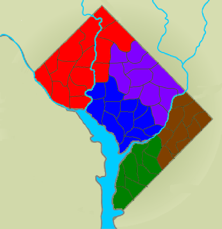
Funny that you would make southeast brown.atr1989 wrote:Here is just a basic idea of what the layout would look like. I would have Northwest (red), Northeast (purple), Southwest (green), Southeast (brown), and the Capitol District (blue). I know I need to make the picture sharper and create better colors, but what do you think?

I really think this is a neat idea, though, it's a little bland at the moment...Here are some ideas I had.
- Subway stations in some of the countries.
- Being able to attack countries on the rivers, but only downstream. Maybe just some of the countries.
- Smaller continents, or at least make some of them smaller, in my opinion it would be really hard to hold even one.
- Images of landmarks around D.C. so it would feel more like Washington D.C.
Last edited by Kem Rixen on Fri Apr 06, 2007 3:28 pm, edited 1 time in total.
-
ParadiceCity9
- Posts: 4239
- Joined: Thu Feb 15, 2007 4:10 pm
Dmunster wrote:Funny that you would make southeast brown.atr1989 wrote:Here is just a basic idea of what the layout would look like. I would have Northwest (red), Northeast (purple), Southwest (green), Southeast (brown), and the Capitol District (blue). I know I need to make the picture sharper and create better colors, but what do you think?
Thats where we used to get our pot when we were in a bind.
lmfao
-
PimpCaneYoAss

- Posts: 185
- Joined: Fri Feb 16, 2007 3:04 pm
- Location: Connecticut
New Map Layout
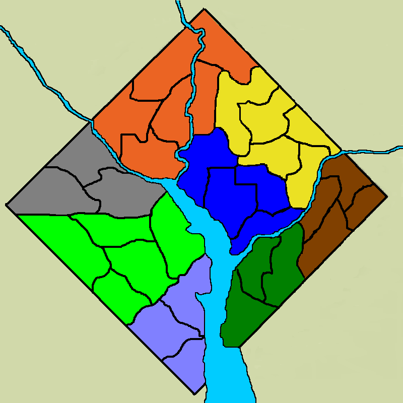
This is the revised map. I have not included any territory or continent names, but I included Arlington and Olde Town Alexandria due to the requests of some.
The continents:
Northwest (orange) - 6 territories
Northeast (yellow) - 5 territories
Southeast (brown) - 4 territories
Southwest (green) - 3 territories
The Mall (blue) - 4 territories
North Arlington (grey) - 3 territories
South Arlington (light green) - 5 territories
Olde Town Alexandria (purple) - 3 territories
I think the continents need a few more territories. What do you think?
I still plan to add bridges and harbors to make it better. I will probably redo this map in an actual program like Fireworks or something like that (I did this in Paint). Any suggestions on what to use?


why don't you have it were the white house could be an additional army and the Washington monument and Lincoln monuments could be the same. and if you have them all they could be worth 5 extra armies or have them attack each other. i don't know but it needs to feel more like Washington d.c not like all other maps with anchors harbors and subways
1546 - top score
New Borders
I know this isn't a priority right now, but I accidentally clicked on my border when I was filling something with color and the borders turned white. I think the white and gray both look better than the black border. What do you think?
(Territory names be put up later today)
Gray borders

White borders

(Territory names be put up later today)
Gray borders
White borders
-
ParadiceCity9
- Posts: 4239
- Joined: Thu Feb 15, 2007 4:10 pm
I like the black best
Last edited by ParadiceCity9 on Sat Apr 07, 2007 10:55 am, edited 1 time in total.
-
PimpCaneYoAss
- Posts: 185
- Joined: Fri Feb 16, 2007 3:04 pm
- Location: Connecticut
-
ParadiceCity9
- Posts: 4239
- Joined: Thu Feb 15, 2007 4:10 pm
-
PimpCaneYoAss
- Posts: 185
- Joined: Fri Feb 16, 2007 3:04 pm
- Location: Connecticut