First of all, I love the idea! I love big complicated maps in CC,
and I love Tolkien. As a young adult I read all his works, and
tried to piece together the maps of the different ages myself.
However, doing so I came up with a composite where 1st Age
Beleriand is much further to the south than on Major King's
map, straight west from Eriador and the Shire. The linker
between the 1st and 3rd Age maps is the mountain of Himring
on the 1st Age map (as originally published in the Silmarillion),
which became the island of Himling after the destruction of
Beleriand, that can be found on the map of Middle Earth (as
originally published in the Lord of the Rings), off the coast of
Forlindon, in the top left corner of the map. On most modern
maps of Middle Earth it is missing, here is one that does show
it, plus a map of Beleriand showing it:
http://www.geocities.com/blackcouncil/m ... eriand.JPG
http://www.illustratorworld.com/users/j ... /a2421.jpg
This leads to approximately the following composite (not made
by me, but by somebody else piecing the same puzzle together):
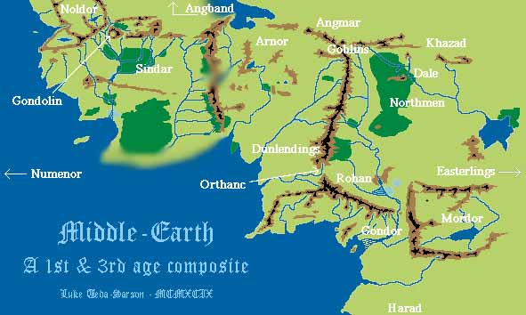
Himring/Himling is the isolated mountain below the arrow
pointing to Angband. However, according to my measurements,
based on the distance of corresponding mountains on both maps,
The Gulf of Lhun should be more to the south, in the right bottom
of the Beleriand map.
Here a map of the entire Tolkien realm, not including Beleriand
(so apparently from the 3rd Age), but showing Himring/Himling
and even a couple more mountains from the Beleriand map as
islands.
http://home.agh.edu.pl/~evermind/images ... _15web.jpg
Not all too accurate, it seems, but at least Numenor is star-shaped,
as it should be.


