Moderator: Cartographers
QFT. Also, I don't live anywhere near LA, so any comments I have right now (ex. "wtf is a orange county?") would be uselessKaplowitz wrote:i have nothing to say so far. I dont know enough about making good gameplay

Be more sure of your comments -- half of us are talking out of our asses when we post. Hope I see you aroundOptimus Prime wrote:I'll take a shot at giving some advice, or at least I hope it is constructive advice....
To me, as I look at the map, it seems that Anaheim and Irvine are absolutely huge. I don't know if that is because those particular "cities" are really that big, or that is just how the map came out, but it seems to me like there is a lot of wasted space sitting around there. I'm not familiar enough with the area, but is there an option for splitting those up a little bit?
Also, the Orange County part seems large for a three border continent, but I don't know a whole lot about that gameplay-wise. Perhaps a route from Huntington Beach to Palos Verdes or Wilmington? If you were wanting to add a fourth border to that one, seems like that would be a logical space.
That's all I've got....hopefully it was worthwhile. I'm trying to be a more active "foundry commenter" in the coming days.
Yeah, you're right on, Optimus. That's the worst part of the map, as it needs to be split up. There are more cities I could throw in to add territories, but unless I can break it into two regions adding more territories just makes it worse. If anybody out there knows Orange County at all, please let me know what makes sense.Optimus Prime wrote:To me, as I look at the map, it seems that Anaheim and Irvine are absolutely huge. I don't know if that is because those particular "cities" are really that big, or that is just how the map came out, but it seems to me like there is a lot of wasted space sitting around there. I'm not familiar enough with the area, but is there an option for splitting those up a little bit?
Also, the Orange County part seems large for a three border continent, but I don't know a whole lot about that gameplay-wise.
It's the 405... and yes, there is a lot of fun to be had with this graphically.cairnswk wrote:And is that a tunnel between Van Nuys and Westwood or the mountain road.
As noted in the first post, I have obviously had to lump areas together in order to make the map manageable... "Great Highway" is everything from El Segundo to Redondo Beach, Wilshire Blvd covers everything north of the 10, etc. I know this map will piss off some people ("I live in Reseda - where the hell is Reseda?!?"), so collectively we should figure out what works best for the map.Mjinga wrote:Where's Gardenia? Why do you have Great Highway and Palos Verdes instead of El Segundo and Redondo Beach? How can you not have Rosemead in it? Why do you have Wilshire Blvd there? Where's Bel Air? Venice? The City of Industry? Garden Grove?
They're not shaped right... Like really not right... you have bits going into other named neighborhoods' bits. And I don't known why you picked some neighborhoods over others, but I've said it before and besides that might be a graphics thing. :SI've obviously lumped cities and neighborhoods together because there's no way I could include every area of, say, Orange County for example. Have I done this in a logical manner?
Yeah, but what can you do... 18 territories isn't ideal, but if somebody decides to play a two/three player game on a big map like this they are taking a big risk that they'll draw a late start a start out with a disadvantage. It's no worse than World 2.0 or any other big map.Mjinga wrote:The first person to go in two and three player games will have a huge advantage. If that person deploys all 6 guys on one territory, it'd be easy to deprive the next dude of one bonus guy in a 9 vs 3.
I can shape them any old way, though I'll take some liberties to make the regions playable. Trouble is how do draw the border between two cities - say Westminster and Costa Mesa - when in reality Fountain Valley is between them? A lot of the borders are just approximations, but I'll gladly take suggestions! And again, when I'm faced with cutting out a city, I don't necessarily know many of these areas well enough to know which one to lose. Brea or Yorba Linda? Norwalk or Artesia? Covina or West Covina? Don't be shy - tell me what to change!They're not shaped right... Like really not right... you have bits going into other named neighborhoods' bits. And I don't known why you picked some neighborhoods over others, but I've said it before and besides that might be a graphics thing. :S

Tack beat me to it. The subways were a stroke of genius on the NYC map, something you only fully realize once you play it. Something similar on this map would be great.TaCktiX wrote:I fourth Incandenza's freeway initiative. It'd be an interesting, and city-appropriate twist to LA. Take NYC for example: when people think about getting around New York, they think subway. When people think about getting around LA...they think of massive gridlock on the interstates.
My concern about eliminating the valleys is that we'd be left with a big flat square with no impassables. Anyway, if we're going to include freeways - which I'm on board with - it makes more sense to me to keep the map stretched out and run them long distances... 101 and the 5 from the valley, the 10 running east west through everything. etc.
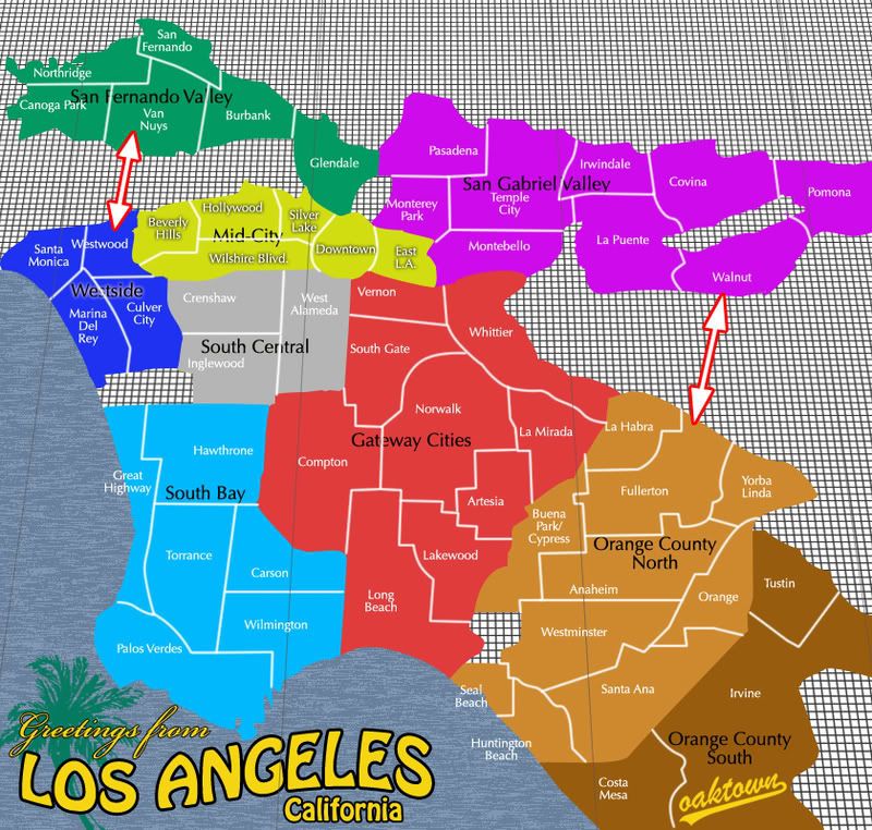
Incandenza wrote:1. I think you could get rid of Orange and the San Gabriel Valley, compact the map, and have more detailed neighborhoods (like Los Feliz, Koreatown, Lincoln Heights, Mar Vista, Naples, etc.) Basically make it a "true" Los Angeles map, as opposed to a Los Angeles Greater Metropolitan Area map.
Gridlock on the 10? Never. (I fondly remember the day that I spent 20 minutes driving from downtown to UCLA, and two hours getting back.)
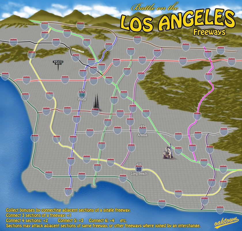
Incandenza wrote:2. Also, freeways were mentioned above, but I'd like to go into more detail about the concept: how about having the 101, 5, 405, 10, maybe the 605, 710, 105, etc, interspersed with onramps and the obvious interchanges. Then you could have one-way attacks on the freeways (in both directions: i.e. 101 North Silverlake would be able to attack 101 North Hollywood as well as 101 Hollywood Offramp, and 101 South Burbank would be able to attack 101 South Hollywood and 101 Hollywood Offramp, but 101 North Hollywood would NOT be able to attack 101 South Hollywood). It would be like a weird synthesis of a traditional geographic map like you have here and Circus Maximus (and it would be unlike anything else on the site). The advantage of the freeways is that you'd be able to (theoretically) only have to kill, say, three terits to get from Santa Monica to Downtown. The disadvantage, of course, is that someone puts a big honkin' army somewhere on the 10 East and creates the dreaded gridlock...
Agreed. When it comes time to think about the graphics I intend to add fun stuff like the Hollywood sign, Watts Towers, and Space Mountain, but that'll just be gravy.Incandenza wrote:3. I don't think you need landmarks or any such, unless you were going to compact it further and go some sort of kitschy Maps of the Stars Homes sort of map. L.A. is a big tourist destination, but it seems to lack many of the traditional sorts of tourist spots like New York or Paris have. People go to Disneyland, the beach, and Hollywood, all of which could theoretically just be terits.