MÉXICO [BETA] p1/18 --Sep 11th--
Moderator: Cartographers
Re: MEXICO [D] p1/7 --May 4th-- New Cartographer
![]() by danfrank on Sun May 10, 2009 8:52 pm
by danfrank on Sun May 10, 2009 8:52 pm
I think you need to add southern California , Arizona, New Mexico, Texas ,, Aw hell ,, how about just add all of the US as a territory 

-
 danfrank
- Posts: 611
- Joined: Mon Dec 24, 2007 1:19 am


Re: MEXICO v5 p1/6 -- New Cartographer
![]() by iancanton on Tue May 26, 2009 4:07 pm
by iancanton on Tue May 26, 2009 4:07 pm
MrBenn wrote:What I'm not too keen on are the numbers of borders in/out of Anillo Centro (the red region on the inset).
we need to extend some of the mountains, for example to block hidalgo from veracruz. fumandomuerte, are there any real mountains that are in a suitable position to protect anillo central?
fumandomuerte wrote:LED ZEPPELINER wrote:i think it is too easy to gain control over the north region, then the south
About that I kind of agree. Maybe MrBenn should inlcude the ports as part of the continents and remove the ports bonuses.
i'm not keen about making the northernmost bonus zone adjacent to the southernmost one. if we remove the port bonuses, then i'd like something else to slow down a direct attack, such as a sea region (as used in alexander's empire), otherwise the assaults will be largely over the water, missing out the most important parts of the country, just as happens in portugal.
ian.

-

iancanton
- Foundry Foreman

- Posts: 2451
- Joined: Fri Jun 01, 2007 5:40 am
- Location: europe


Re: MEXICO [D] p1/7 --May 4th-- New Cartographer
![]() by MrBenn on Wed May 27, 2009 9:13 am
by MrBenn on Wed May 27, 2009 9:13 am
I've spent a bit of time over the past couple of weeks tweaking things around, and have another update...
The borders have more of a Mexican/Aztec feel to them now, and I've incorporated the colours from the national flag too.
I've extended some of the mountain ranges towards the middle of the map, and have redrawn the Ports/Docks; I've tried to create a motif that vaguely fits the theme, but is distinctly port-esque.
To Do:
-The borders and Anillo Centro inset need to be redrawn; to make it more clear what goes where.
-Once the location of the mountains has been confirmed, they need to be redrawn to.
-It would be nice to add a third port on the West side to balance out the ports bonus.
Any and all feedback is welcome
- Click image to enlarge.
The borders have more of a Mexican/Aztec feel to them now, and I've incorporated the colours from the national flag too.
I've extended some of the mountain ranges towards the middle of the map, and have redrawn the Ports/Docks; I've tried to create a motif that vaguely fits the theme, but is distinctly port-esque.
To Do:
-The borders and Anillo Centro inset need to be redrawn; to make it more clear what goes where.
-Once the location of the mountains has been confirmed, they need to be redrawn to.
-It would be nice to add a third port on the West side to balance out the ports bonus.
Any and all feedback is welcome

PB: 2661 | He's blue... If he were green he would die | No mod would be stupid enough to do that
-

MrBenn
- Posts: 6880
- Joined: Wed Nov 21, 2007 9:32 am
- Location: Off Duty


Re: MEXICO [D] p1/7 --May 4th-- New Cartographer
![]() by lgoasklucyl on Wed May 27, 2009 10:34 am
by lgoasklucyl on Wed May 27, 2009 10:34 am
Just a quick nitpick, graphically.
In the mountain range running through Durango, you have a mountain on top of another that looks kind of weird.
It's about 7 mountains down and is covering the snow-cap of the next mountain in line.
I don't know if it was supposed to be like this to mix it up, but it seems like it could either be moved to the right a little (exposing the snow-cap) or moved back on top of the other mountain.
All in all, looking great thus far. Couldn't tell for the life of me it was a Benn map if I didn't see your username next to it! (not a bad thing, lol, just not your usual graphic style!)

-

lgoasklucyl
- Posts: 526
- Joined: Mon Apr 07, 2008 8:49 pm
- Location: Somewhere in the 20th century.


Re: MEXICO [D] p1/7 --May 4th-- New Cartographer
![]() by the.killing.44 on Wed May 27, 2009 11:16 am
by the.killing.44 on Wed May 27, 2009 11:16 am
Hmm, graphically. Just a thing, that dotted square line you have runs through names, I suggest you get rid of it. Besides the mountains this is nice! 
.44
.44
-

the.killing.44
- Posts: 4724
- Joined: Thu Oct 23, 2008 7:43 pm
- Location: now tell me what got two gums and knows how to spit rhymes


Re: MEXICO [D] p1/7 --May 4th-- New Cartographer
![]() by AndyDufresne on Wed May 27, 2009 1:20 pm
by AndyDufresne on Wed May 27, 2009 1:20 pm
I like the general look of the map---the background water, the land texture, some of the border outlines for things---but the border at the top and bottom of the map...hm...too much. I kind of liked the simpler scheme that was there a while ago---or some other simpler scheme.
--Andy
--Andy
-

AndyDufresne
- Posts: 24935
- Joined: Fri Mar 03, 2006 8:22 pm
- Location: A Banana Palm in Zihuatanejo


Re: MEXICO [D] p1/7 --May 4th-- New Cartographer
![]() by MrBenn on Wed May 27, 2009 1:20 pm
by MrBenn on Wed May 27, 2009 1:20 pm
lgoasklucyl wrote:In the mountain range running through Durango, you have a mountain on top of another that looks kind of weird.
The mountains will be redone from scratch in due course - I just cloned them to extend them in a couple of places while I iron out the gameplay
the.killing.44 wrote:that dotted square line you have runs through names
Some of the territory names need to be moved around a bit... If you're referring to the red inset map, then that whole bit is going to be redone soon too
PB: 2661 | He's blue... If he were green he would die | No mod would be stupid enough to do that
-
MrBenn
- Posts: 6880
- Joined: Wed Nov 21, 2007 9:32 am
- Location: Off Duty
Re: MEXICO [D] p1/7 --May 4th-- New Cartographer
![]() by MrBenn on Wed May 27, 2009 1:47 pm
by MrBenn on Wed May 27, 2009 1:47 pm
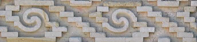
fumandomuerte wrote:Maybe a precolumbian pattern for the borders would look better.
Take this from Oaxaca as an example:
AndyDufresne wrote:the border at the top and bottom of the map...hm...too much.
The border was changed in response to the above PM from fumandomuerte. It looks heaps better after I added the colour to it as well, and I quite like it
edit: bumping image...
- Click image to enlarge.
PB: 2661 | He's blue... If he were green he would die | No mod would be stupid enough to do that
-
MrBenn
- Posts: 6880
- Joined: Wed Nov 21, 2007 9:32 am
- Location: Off Duty
Re: MEXICO [D] p1/7 --May 4th-- New Cartographer
![]() by AndyDufresne on Wed May 27, 2009 1:48 pm
by AndyDufresne on Wed May 27, 2009 1:48 pm
I'm all in favor of making it more representative, I was just hoping for a simpler representative!
--Andy
--Andy
-
AndyDufresne
- Posts: 24935
- Joined: Fri Mar 03, 2006 8:22 pm
- Location: A Banana Palm in Zihuatanejo
Re: MEXICO [D] p1/7 --May 4th-- New Cartographer
![]() by MrBenn on Wed May 27, 2009 1:50 pm
by MrBenn on Wed May 27, 2009 1:50 pm
I tried a version which replicated the pattern above, but it looked awful - the circles were a bit hypnotic!
PB: 2661 | He's blue... If he were green he would die | No mod would be stupid enough to do that
-
MrBenn
- Posts: 6880
- Joined: Wed Nov 21, 2007 9:32 am
- Location: Off Duty
Re: MEXICO [D] p1/8 --May 27th-- New Cartographer
![]() by men chuch! on Thu May 28, 2009 12:35 am
by men chuch! on Thu May 28, 2009 12:35 am
Hi, this is an originally sent PM to MrBenn, but I think it will be more useful in here:
The feedback (and complains) apply to everybody
Hello, the reason I'm wrtiting to you is for giving you an opinion. I'm Mexican and I really appreciate your efort developing a CC Map of our country; I've seen your work and I think it's awesome, but also I'm noticing that there are some things that can be changed so it becomes even a more accurate CC map.
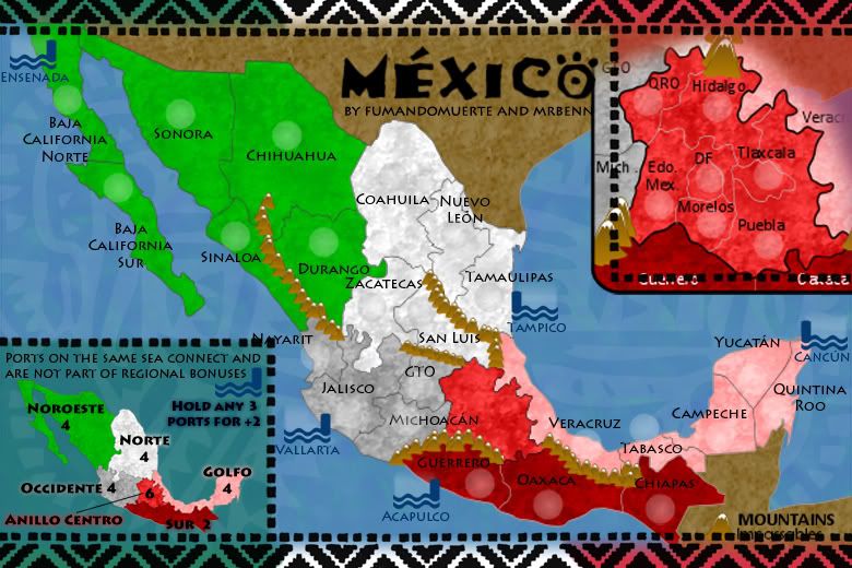
For example, the region called "Anillo Central" can be renamed as "Valle de Anáhuac" since it covers almost all the territories shown in the map.
In the ports aspect, I think that they can take a more relevant roleplay; in the Pacific Coast you can add "Mazatlán" as a port in the territory of "Sinaloa", also you can add "Manzanillo in a new territory called "Colima" (Colima is a little Mexican state located between the states of Jalisco and Michoacan
Finally, the territory called "Baja California Norte" corresponds to the state of "Baja California". For keeping a high accuracy level, I strongly recommend you to change the name to "Baja California" since that's the state's "official" name (The complete official state is "Estado Libre y Soberano de Baja California", but I don't think that putting the entire name of every single state is the best idea for developing this map
Any feedback of further questions (or complains xD), please feel free to send a Private Message.
The feedback (and complains) apply to everybody
-

men chuch!
- Posts: 29
- Joined: Fri Jul 20, 2007 11:44 pm


Re: MEXICO [D] p1/8 --May 27th-- New Cartographer
![]() by MrBenn on Fri May 29, 2009 4:10 am
by MrBenn on Fri May 29, 2009 4:10 am
Thanks men chuch! - your post is a really good example of quality feedback
1. I can easily rename 'Anillo Centro' as 'Valle de Anáhuac'.
2. As for the ports, there is currently one port in each 'region', and I'm not too sure how adding more ports to the Pacific side would work from a gameplay point of view, as they have a side-effect of making things a lot more connected and harder to defend.
3. I can certainly have a look at adding Veracruz on the Atlantic side, as this will make three ports on each ocean, making the current ports bonus more balanced.
4. I'll add Colima as a new territory
5. Baja California Norte will be renamed.
I'll have another update ready fairly soon, and will try and reflect these changes.
PB: 2661 | He's blue... If he were green he would die | No mod would be stupid enough to do that
-
MrBenn
- Posts: 6880
- Joined: Wed Nov 21, 2007 9:32 am
- Location: Off Duty
Re: MEXICO [D] p1/8 --May 27th-- New Cartographer
![]() by iancanton on Sun May 31, 2009 6:53 am
by iancanton on Sun May 31, 2009 6:53 am
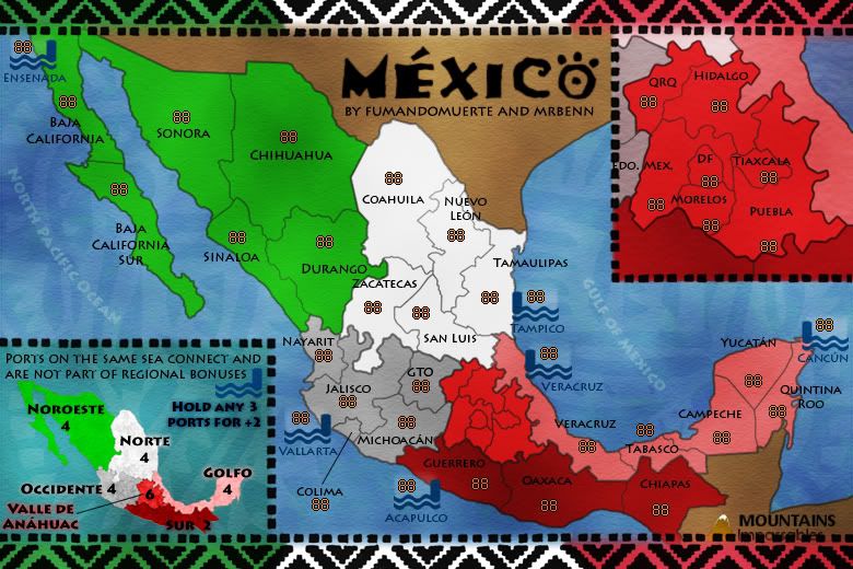
i like the new mountains between guerrero and anillo central. now u just need to do the same to the minimap.
ian.
ian.
-
iancanton
- Foundry Foreman
- Posts: 2451
- Joined: Fri Jun 01, 2007 5:40 am
- Location: europe
Re: MEXICO [D] p1/8 --May 27th-- New Cartographer
![]() by Alex ceu on Mon Jun 01, 2009 6:32 pm
by Alex ceu on Mon Jun 01, 2009 6:32 pm
Graphics are awesome now.
I liked the anillo central with territories inside, would like to see some kind of "player who controls most part of inside anillo central territories controls the capital wich has some sort of bonus" but thats just my opinion, i would recomend you to change that ugly mountains(they arent good looking and obstructs territory space) for thick lines.
Im looking foward to so how it mutates and becomes an interesting map to play
-
Alex ceu
- Posts: 10
- Joined: Wed Apr 29, 2009 7:13 am

Re: MEXICO [D] p1/7 --May 4th-- New Cartographer
![]() by RjBeals on Thu Jun 04, 2009 11:58 am
by RjBeals on Thu Jun 04, 2009 11:58 am
- Click image to enlarge.
It's coming along Benn. Take these comments as constructive, and not elitist
You've got a good color pallet, but there's just something that doesn't feel right about this map. Most of the Mexican images I find have yellows/oranges/browns in them. Warmer images. Here's some things to try -
- The land texture - it reminds me of quartz rock. It doesn't look appropriate for terrain. Also, even though you use red, the map is more cold feeling than warm. Maybe you wanna try not using the flag colors for the land, but instead a nice warm pallet. Stick the flag in there somewhere though.
- The water texture - eh.. it's very flat feeling.
- I dislike the top/bottom pattern. I know it's a hot topic now - Try looking some of the images i posted for inspiration
- I also think you can do better with the mountain range. A lot better. Mountains are difficult. To get good ones, it's going to take some paintbrush skills. You'll have to shade some areas by hand, make some inconsistencies, and not just rely on a pattern brush.
- Your call-out box & legend box are covering text. and it's touching the O in the title.
- Mexico should be ornamental bright patterns. You're bright, but the patterns could use a little more work.


Photoshop Brushes
http://silv3rdu5t-stock.deviantart.com/ ... s-14553297
http://www.nuclearblue.com/pages/brushe ... mexico.zip
---------------------------------------------------
Edit: If you really want to refine your mountain skills -here's a tutorial that I found on http://www.cartographersguild.com/ which i uploaded to my account, since only members can view their tutorials. It's how to draw mountains by hand (with a pencil), and then scan them into photoshop, and make custom brushes with them. It's a great tut - check it out.
http://www.rjbeals.com/files/mountain_tutorial.PDF

-

RjBeals
- Posts: 2506
- Joined: Mon Nov 20, 2006 5:17 pm
- Location: South Carolina, USA


Re: MEXICO [D] p1/8 --May 27th-- New Cartographer
![]() by MrBenn on Thu Jun 04, 2009 3:33 pm
by MrBenn on Thu Jun 04, 2009 3:33 pm
Cheers RJ (you foundry elitist snob)
I haven't looked at the mountains yet - they are pretty much as they were when I took over the map. I cloned some mountains to extend the impassables in some places, but for the moment I'm treating them as placeholders until it's been decided where they're going to go.
The background land texture and colours are also as they were in the file I adopted. I'll have a play around in due course, but will probably stick with the Mexican Flag colour scheme. There is plenty of time to tweak the reds, greens and whites yet
Most of the other things you mentioned will be taken care of in due course ...
PB: 2661 | He's blue... If he were green he would die | No mod would be stupid enough to do that
-
MrBenn
- Posts: 6880
- Joined: Wed Nov 21, 2007 9:32 am
- Location: Off Duty
Re: MEXICO [D] p1/7 --May 4th-- New Cartographer
![]() by TaCktiX on Wed Jun 10, 2009 2:11 am
by TaCktiX on Wed Jun 10, 2009 2:11 am
I'm going to agree with Rj, the color palette and the textures just aren't working. In addition:
Graphics
- A mexican flag green instead of a turquoise not-green for the borders. Cull out the color scheme from the map, but make the one for the borders 100% standard.
- As authentic as I know the banners' jaggedness is, it seems pixelated. Perhaps a different pattern elicitive of Mexico?
- The port icons have got to go.
- I think there's a better way to do the inset out there somewhere, so try around with some of it.
- The Mexico-themed pattern on the ocean just doesn't work. Let the Mexico patterns show up elsewhere on map, and let land and sea features look like the land and sea.
- Aim for a more solid difference between map and borders. Right now it "glows" out to the map, and it just isn't the right look in my opinion.
Gameplay
- The font, as appropriate as it is to the region, exacerbates the problem of territory names going over into other territories, across impassables, etc. That, and there are several different fonts in use on map (bonus regions, territory names on main map, territory names on inset). Pick one or two, stick with them and be consistent. Find a thin font instead of the wide ones you have right now.
- Most of the territory names are put in places where they can be confused with other territory names or other territories. It's not possible on a second review, but a quick glance to see the next territory to attack will cause errors (see: Soviet Union for another example of this problem).
- Lots of the territory names cross boundaries, making them very difficult to read. That needs to get fixed ASAP.
Ask and ye shall receive, I consider Mexico
 .
.
Graphics
- A mexican flag green instead of a turquoise not-green for the borders. Cull out the color scheme from the map, but make the one for the borders 100% standard.
- As authentic as I know the banners' jaggedness is, it seems pixelated. Perhaps a different pattern elicitive of Mexico?
- The port icons have got to go.
- I think there's a better way to do the inset out there somewhere, so try around with some of it.
- The Mexico-themed pattern on the ocean just doesn't work. Let the Mexico patterns show up elsewhere on map, and let land and sea features look like the land and sea.
- Aim for a more solid difference between map and borders. Right now it "glows" out to the map, and it just isn't the right look in my opinion.
Gameplay
- The font, as appropriate as it is to the region, exacerbates the problem of territory names going over into other territories, across impassables, etc. That, and there are several different fonts in use on map (bonus regions, territory names on main map, territory names on inset). Pick one or two, stick with them and be consistent. Find a thin font instead of the wide ones you have right now.
- Most of the territory names are put in places where they can be confused with other territory names or other territories. It's not possible on a second review, but a quick glance to see the next territory to attack will cause errors (see: Soviet Union for another example of this problem).
- Lots of the territory names cross boundaries, making them very difficult to read. That needs to get fixed ASAP.
Ask and ye shall receive, I consider Mexico
.-

TaCktiX
- Posts: 2392
- Joined: Mon Dec 17, 2007 8:24 pm
- Location: Rapid City, SD


Re: MEXICO [D] p1/8 --May 27th-- New Cartographer
![]() by Incandenza on Tue Jun 16, 2009 1:52 am
by Incandenza on Tue Jun 16, 2009 1:52 am
One problem I have generally with the gameplay is that the vast majority of terits are border terits... I count only 8 non-border terits (3 in anillo central, 5 outside such), which is rather small for a standard gameplay bonus-based map. For comparison, Classic has 8 non-border terits in the western hemisphere alone. Africa has 21, Benelux has 17, Europe has 20, Middle East has 17, etc. Cairns Metro only has 7, but that map has a ton of small easy bonuses, which this map lacks.
What this tells me is that trying to hold a bonus will not, save in rare circumstances, be a viable strategy, unless bonuses are either broken up into smaller entities or made easier to hold.
What this tells me is that trying to hold a bonus will not, save in rare circumstances, be a viable strategy, unless bonuses are either broken up into smaller entities or made easier to hold.
THOTA: dingdingdingdingdingdingBOOM
Te Occidere Possunt Sed Te Edere Non Possunt Nefas Est
Te Occidere Possunt Sed Te Edere Non Possunt Nefas Est
-

Incandenza
- Posts: 4949
- Joined: Thu Oct 19, 2006 5:34 pm
- Location: Playing Eschaton with a bucket of old tennis balls

Re: MEXICO [D] p1/8 --May 27th-- New Cartographer
![]() by iancanton on Thu Jun 18, 2009 1:58 pm
by iancanton on Thu Jun 18, 2009 1:58 pm
querétaro and guanajuato need to be written in full somewhere, since most people do not know what QRO and GTO are.
add colima to the occidente bonus zone? however, not as a port. how about removing one of the ports from the pacific, to reduce the number of seaborne attack routes and force more land-based action?
ian.
Incandenza wrote:One problem I have generally with the gameplay is that the vast majority of terits are border terits... I count only 8 non-border terits (3 in anillo central, 5 outside such), which is rather small for a standard gameplay bonus-based map.
men chuch! wrote:Colima is a little Mexican state located between the states of Jalisco and Michoacan
add colima to the occidente bonus zone? however, not as a port. how about removing one of the ports from the pacific, to reduce the number of seaborne attack routes and force more land-based action?
ian.
-
iancanton
- Foundry Foreman
- Posts: 2451
- Joined: Fri Jun 01, 2007 5:40 am
- Location: europe
Re: MEXICO [D] p1/8 --May 27th-- New Cartographer
![]() by Incandenza on Tue Jun 23, 2009 2:47 am
by Incandenza on Tue Jun 23, 2009 2:47 am
I hate to say it, but I'm not sure subtle tweaks are going to solve the whole "almost every terit is a bonus border" problem. Your best bet might be to hunker down with a map of Mexico's internal political borders and start from scratch... and have an end goal in mind. A shitload of small bonuses wouldn't be a bad idea, and might fit with the theme of the map, given Mexico's at time chaotic internal politics.
THOTA: dingdingdingdingdingdingBOOM
Te Occidere Possunt Sed Te Edere Non Possunt Nefas Est
Te Occidere Possunt Sed Te Edere Non Possunt Nefas Est
-
Incandenza
- Posts: 4949
- Joined: Thu Oct 19, 2006 5:34 pm
- Location: Playing Eschaton with a bucket of old tennis balls
Re: MEXICO [D] p1/8 --May 27th-- New Cartographer
![]() by MrBenn on Tue Jun 23, 2009 3:33 pm
by MrBenn on Tue Jun 23, 2009 3:33 pm
Here's where I'm at so far:
The most obvious omission is the lack of mountains.
Some of the placement of territory names is a bit clumsy, but I'll move them around in due course.
I've changed the green in the border to be a bit more green.
I'm not tied to the ports at all - they were on fumandomeurte's drafts, so I've carried them over. I won't lose any sleep over keeping them or not - I'm happy either way
As for the regions, I guess there could be some rejigging - I found this political/regional map: I could split the central regions up?
PB: 2661 | He's blue... If he were green he would die | No mod would be stupid enough to do that
-
MrBenn
- Posts: 6880
- Joined: Wed Nov 21, 2007 9:32 am
- Location: Off Duty
Re: MEXICO [D] p1/8 --May 27th-- New Cartographer
![]() by AndyDufresne on Tue Jun 23, 2009 10:12 pm
by AndyDufresne on Tue Jun 23, 2009 10:12 pm
On the political map, adding in either the light blue or yellow, to break up repeated "Bonus of 4's" might be worth looking into---which ever section break makes sense...in a political sense.
--Andy
--Andy
-
AndyDufresne
- Posts: 24935
- Joined: Fri Mar 03, 2006 8:22 pm
- Location: A Banana Palm in Zihuatanejo
Re: MEXICO [D] p1/8 --May 27th-- New Cartographer
![]() by Incandenza on Tue Jun 23, 2009 10:36 pm
by Incandenza on Tue Jun 23, 2009 10:36 pm
Not to be Debbie Downer, but unless you're planning on going a new direction with the gameplay, I'm not sure a political map of Mexico lends itself particularly well to solid gameplay...
THOTA: dingdingdingdingdingdingBOOM
Te Occidere Possunt Sed Te Edere Non Possunt Nefas Est
Te Occidere Possunt Sed Te Edere Non Possunt Nefas Est
-
Incandenza
- Posts: 4949
- Joined: Thu Oct 19, 2006 5:34 pm
- Location: Playing Eschaton with a bucket of old tennis balls
Re: MEXICO [D] p1/8 --May 27th-- New Cartographer
![]() by whitestazn88 on Wed Jun 24, 2009 4:00 am
by whitestazn88 on Wed Jun 24, 2009 4:00 am
looks pretty good.
-
whitestazn88
- Posts: 3128
- Joined: Mon Feb 05, 2007 2:59 pm
- Location: behind you
Re: MEXICO [D] p1/8 --May 27th-- New Cartographer
![]() by Alex ceu on Fri Jun 26, 2009 9:22 am
by Alex ceu on Fri Jun 26, 2009 9:22 am
Why not involving inner-territory battles? like in whales(is it whales?) or battle for irak, and making the bonus borders frontiers almost impassible opening them alwas to anillo central and maybe in one or two other cases like chihuaha-coahuila or chiapas-tabasco. This would add in my opinion a lot more strategy and a more complex map to play with.
About graphics are improving a lot, textures are smoother and merge well , the ocean improved a lot too!
Way to go!
About graphics are improving a lot, textures are smoother and merge well , the ocean improved a lot too!
Way to go!
-
Alex ceu
- Posts: 10
- Joined: Wed Apr 29, 2009 7:13 am
Who is online
Users browsing this forum: No registered users
|
|||||||
| Conquer Club is not associated with RISK online in any way. Copyright © 2006-2025 by Big Wham LLC | |||||||