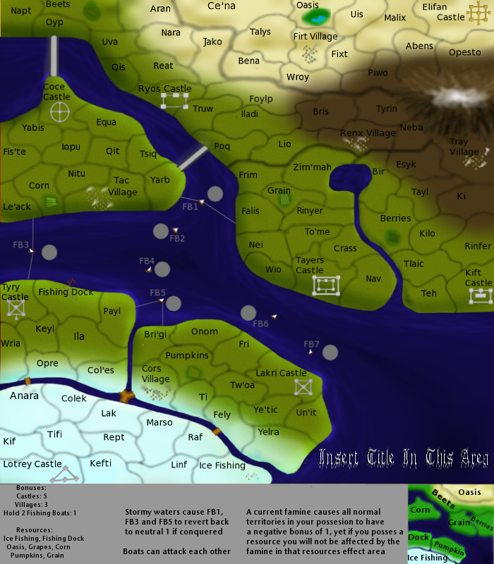
t-o-m wrote:this map seems to me like a cross between AoR (with the resource pairs) and feudal (with castles).
the mountain looks slightly realistic but it seems randomly placed and not on the ground - it looks like it is floating
the boats are a rip off from cairnswk's egypt map's dows.
the font youre using for "insert title here" is completely wrong for the style of your map
the colour of the land looks like someone has been sick all over it - if there is famine then why is there so much water? wouldnt people go and grow crops with that? maybe have a graduated famine form the water - or have the water level lower and less blue.
getting onto the water it looks streeky - i understand that youre trying to make it look wavey but it really isnt working in my opinion
the terit font need looking at
the font colou needs looking at
why is there so much shadow around the mountain that is a really weird shape and doesnt fit the actual mountain's shape.
maybe the mountain is bigger and is half off screen so it looks like tis coming from another region?
are the things connecting the pieces of land bridges or what?
the terit name "teh" just looks like it is a typo
the miini-map doesnt look like the land at all
there is no point having boats if there are bridges anyway
is it meant to be the case that Le'ack can get to falis with taking 2 terits?
the terit names overall are quite un-orignial and the cont names...pumpkin!?

are you serious!?
the terit lines just look like blurey squiglly lines
the resources are not clear that they are resources
FB1 and things are no use going back to one neutral per turn as they are too easily conquerable so ther is no point
what does tray village do? (in fact all villages?)
anyway - when are you starting on the high graphics version?
TY tom that has been mentioned time and time again

Yea i realized that now. The reason why I think is because that the rest of the map seems sort of.... flat... compared to the mountain
Oh yea right! Check the date of when I started this map, then check the date that cairns started the egypt map! anyways im drawing the boats the same way ive ALWAYS drawn it.
Yea i know, the font will be different when we finally have a title......
True, there is a whole lot of water. Ill have to take some out/make it smaller/lower level/maybe less blue.
Yea thats because DiM taught me that way, i might have a way to change that.....
Sure, what font do u suggest?
Why the color?
Could u explain more? i dont exactly get your meaning
Yea have of it is off the screen
Yes some are land, some are connections to boats and then a different section of land
Whats a typo? sorry ive never heard of "typos"
Yea ive been trying to fix that, but been running into some problems
Yes there is a point for boats. The bridges connect the thinner sections of the giant river, and the boats connect the wider sections
Oh i didnt realize that...
Its not cont names, its resource effect areas. And I could use an online generator to create different names
Yes they are blurry on purpose, u completely missed that poll a while back...... and ive simplified some on occasion
Yea thats been something ive been having problems with
Ive been considering having fb1, 3, and 5 being 6 neutral, and reverting back to that
The villages give u an extra bonus
hmmm.... didnt know i was starting on one, but do you guys think this needs another revamp? from Empire Builder to Famine?