Conquer Club

Conquest Italia [Abandoned]

Have an idea for a map? Discuss ideas and concepts here.

Moderator: Cartographers

Forum rules
Please read the Community Guidelines before posting.

Which do you prefer, the original or alternate.

 
Total votes : 0

Conquest Italia [Abandoned]

Postby matteo11 on Tue Sep 12, 2006 11:19 pm

Image

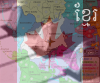
or an alternate look for the map(revised3)...

Image

and a small version(revised) with a simpler sea plus army circles:

Image

please let me know which you prefer.

To see the historical progression of these maps please visit the 'Italy Map History' thread.

Title: Conquest Italia

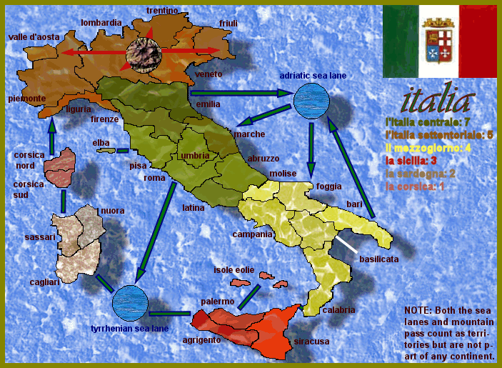
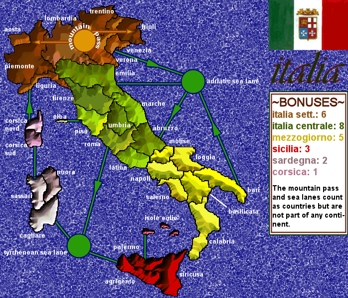
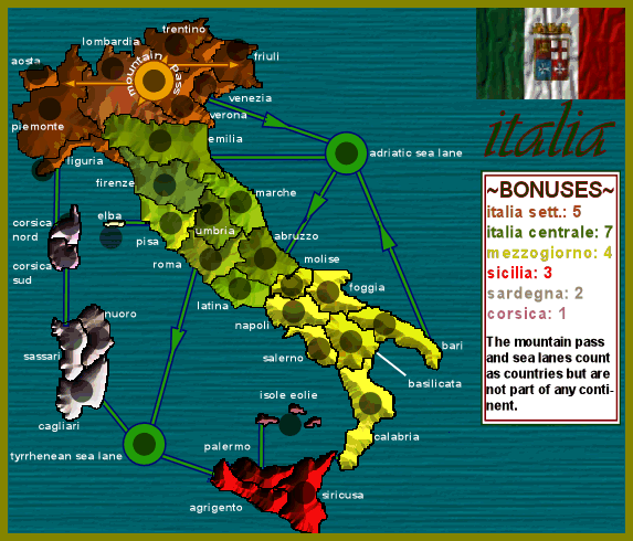
The Italia map contains 31 countries distributed among 6 continents. In addition to the traditional countries the map includes 3 special territories: 2 sea lanes and one mountain pass. These territories
count as countries when assigning armies based on the number of countries held but do not belong
to any continent (this means, for example, that a player can collect the armies for Italia Settentoriale even without controlling the mountain pass). The sea lanes will determine how the islands and various sea bordering countries are in communication with each other. The idea for the mountain pass is for it to be attackable from only one country while being able to attack any other country in Italia Settentoriale with the exception of Valle D'Aosta and Liguria.

I hope this collaborative process will lead to a map that is innovative, fun to play, and aesthetically pleasing. I look forward to everyone's constructive criticism and would particularly like to ask for
help on the awarding of bonuses, the management of the special territories, and any way to make this map a unique experience.

CREDIT WHERE CREDIT IS DUE:

The only other attempt to develop an Italian map I am aware of was undertaken by Happysadfun. I commend him/her for the effort. Reading his/her thread helped me immensely in the early stages of my planning. I would like also to thank Mr. K, from whose Alexander Map my idea for sea lanes was born.
And finally, a very warm thanks to all those who run Conquer Club and make this high quality free entertainment possible.

--matteo11

LINKS TO VISUAL RESOURCES:
1) The basic outline for the map comes from: http://www.governo.it/Istituzioni/index.html
2) The flag of the Marina Militare Italiana comes from: http://www.marina.difesa.it/storia/Trad ... ndiera.htm
3) The snippet of mountain for the mountain pass comes from: en.wikipedia.org/wiki/San_Bernardino_Mountains
4) The snippet of water for the sea lanes comes from from: http://www.ra.ethz.ch/sabbatical2002/20 ... index.html
Last edited by matteo11 on Sun Sep 17, 2006 5:34 pm, edited 10 times in total.
Private 1st Class matteo11
 
Posts: 27
Joined: Fri Sep 01, 2006 7:16 pm

Postby Mr. K on Wed Sep 13, 2006 12:55 am

I would like also to thank Mr. K, from whose Alexander Map my idea for sea lanes was born.

:wink:

Best of luck on this map!
User avatar
Lieutenant Mr. K
 
Posts: 291
Joined: Thu Mar 16, 2006 9:14 pm

2 DRAFT

Postby matteo11 on Wed Sep 13, 2006 2:39 pm

second draft

I have elaborated the workings of the sea lanes and added a graphical aid for the mountain pass. Solid bars are two way and those with an arrow are one way.

The countries are comprised mostly of Italy's regions, but I have broken up Toscana, Lazio, Puglia, Sicilia, and Sardegna in order to generate more countries. The addition of Corsica, which belongs to France not Italy, is also for the same reason. These divisions, while loosely based on actual provinces, do not necessarily correspond to any real administrative borders.

Other licenses taken include the horizontal stretching of the map (in order to increase the size of the countries) and my "hand" drawings of Corsica, Elba, and the Aeolian Islands. I would also note that the sea lanes are pure fantasy and do not reflect, to my knowledge, any actual currents.


looking forward to your comments,

--matteo11
Last edited by matteo11 on Wed Sep 13, 2006 9:04 pm, edited 1 time in total.
Private 1st Class matteo11
 
Posts: 27
Joined: Fri Sep 01, 2006 7:16 pm

Postby happysadfun on Wed Sep 13, 2006 3:03 pm

Better than mine, maybe add in elba if you need more. I'll work on mine as "alps area." Why is Corsica part gone, tho?
ImageChildren, this is what happens to hockey players, druggies, and Hillary Clinton.

Rope. Tree. Hillary. Some assembly required.
User avatar
Cadet happysadfun
 
Posts: 1251
Joined: Mon Jul 10, 2006 9:06 pm
Location: Haundin at DotSco, Being Sad that Mark Green Lost in Suburban Wisconsin

corsica+elba

Postby matteo11 on Wed Sep 13, 2006 4:23 pm

Corsica is on the map Sadhappyfun. It is located between Sardegna and Liguria. Elba is already there too, it is just to the left of Pisa.

Best of luck with the Alps map,

--matteo11
Private 1st Class matteo11
 
Posts: 27
Joined: Fri Sep 01, 2006 7:16 pm

Postby thejackofhearts on Wed Sep 13, 2006 5:42 pm

I would Change the text color, it blends in too well with the water.
User avatar
Cook thejackofhearts
 
Posts: 128
Joined: Sun Jul 16, 2006 5:33 pm
Location: On top of the Queen of Hearts

text

Postby matteo11 on Wed Sep 13, 2006 6:32 pm

Thanks for your feedback thejackofhearts. The old text was rather unattractive. I hope you find this new version an acceptable solution. I have also improved the graphics for the directional markers, changed the route from Corsica to Liguria to one way, and added Molise's name (which I have placed in Southern Italy even though it is usually assigned to central Italy).

--matteo11
Last edited by matteo11 on Wed Sep 13, 2006 9:04 pm, edited 1 time in total.
Private 1st Class matteo11
 
Posts: 27
Joined: Fri Sep 01, 2006 7:16 pm

Postby devilseyesdd on Wed Sep 13, 2006 7:21 pm

italy sucks hate italiens no offence
User avatar
Cook devilseyesdd
 
Posts: 35
Joined: Sun Jul 23, 2006 12:58 pm

Italy map

Postby Bad Speler on Wed Sep 13, 2006 7:58 pm

Consider adding a path from Siracusa to Calabria. This will aid in being able to move around. Currently the only way to get from both territories is by going around the whole map.
Highest Score: 2532
Highest Position: 69 (a long time ago)
User avatar
Sergeant 1st Class Bad Speler
 
Posts: 1027
Joined: Fri Jun 02, 2006 8:16 pm
Location: Ottawa

Postby P Gizzle on Wed Sep 13, 2006 8:30 pm

i dont know. :? :| if u do make the map, plz bring out the color of the sea and mountain lanes. i could barely see them
Gridiron Gang- CC's largest Clan!
User avatar
Cook P Gizzle
 
Posts: 4100
Joined: Fri Aug 04, 2006 5:00 pm
Location: Somewhere being absolutely AWESOME!

bridge and color

Postby matteo11 on Wed Sep 13, 2006 8:46 pm

Thanks for the input Bad Speler and P Gizzle. I have added a bridge between Calabria and Siricusa to make their connection more apparent.
The sea and mountain lanes show up very well on my monitor (were you looking at the latest version of the map or one of the first two?), but I suppose I could change them to web safe colors if P Gizzle's problem is something many others have.

--matteo11
Last edited by matteo11 on Wed Sep 13, 2006 8:49 pm, edited 1 time in total.
Private 1st Class matteo11
 
Posts: 27
Joined: Fri Sep 01, 2006 7:16 pm

Postby P Gizzle on Wed Sep 13, 2006 8:48 pm

thanks for considering my input! :D :D
Gridiron Gang- CC's largest Clan!
User avatar
Cook P Gizzle
 
Posts: 4100
Joined: Fri Aug 04, 2006 5:00 pm
Location: Somewhere being absolutely AWESOME!

new draft

Postby matteo11 on Wed Sep 13, 2006 9:08 pm

I have edited the first post to show the latest version of the draft. From now on I will edit the first post to show new versions to make sure everyone is refering to the same map. Do you still have trouble seeing the lanes P Gizzle? Is the small bridge enough to make the connection between Calabria and Siricusa apparent Bad Speler?

Once again...thanks for the help,

--matteo11
Private 1st Class matteo11
 
Posts: 27
Joined: Fri Sep 01, 2006 7:16 pm

Postby P Gizzle on Wed Sep 13, 2006 9:15 pm

it's better. thanks for considering my issues :wink:
Gridiron Gang- CC's largest Clan!
User avatar
Cook P Gizzle
 
Posts: 4100
Joined: Fri Aug 04, 2006 5:00 pm
Location: Somewhere being absolutely AWESOME!

Postby Bad Speler on Wed Sep 13, 2006 9:23 pm

yes, the bridge is more apparent now.
Highest Score: 2532
Highest Position: 69 (a long time ago)
User avatar
Sergeant 1st Class Bad Speler
 
Posts: 1027
Joined: Fri Jun 02, 2006 8:16 pm
Location: Ottawa

Postby Bad Speler on Wed Sep 13, 2006 9:26 pm

You should add more texture to the yellow continent. It seems all other continents have texture, but yelloww doesnt. It might be because yellow is a bright colour. Also, a very very minor correction, the "l" in l'italia settentoriale is in green, whereas the rest of the word is in brown.
Highest Score: 2532
Highest Position: 69 (a long time ago)
User avatar
Sergeant 1st Class Bad Speler
 
Posts: 1027
Joined: Fri Jun 02, 2006 8:16 pm
Location: Ottawa

Postby tomatoman25 on Wed Sep 13, 2006 9:32 pm

One thing i would revise is the placement of most of the country names. A large majority of the names are hanging loosely in the sea. granted, this works usually very well, but only if there isnt enough room in the country itself to fit the text. for some of the larger countries right in the middle green/earty color "continent" a lot of the country names would easily fit.
User avatar
Sergeant 1st Class tomatoman25
 
Posts: 46
Joined: Wed Mar 01, 2006 9:43 pm
Location: Wisconsin

new draft: southern texture and country names

Postby matteo11 on Wed Sep 13, 2006 11:22 pm

A new draft map is up which attempts to address Bad Speler's concern with the Southern continent's (Il Mezzogiorno) texture. I have also fixed the color discrepancy noted by the same in the bonus legend.

Tomotaman raises an issue with the placement of the country names. I too debated whether to place them within the countries or adjacent to them. I decided on the latter for the following reasons:

1)Playability: I would rather obstruct the background than the field of play.
2)Aesthetics: All but one name (Umbria) can be placed next to the countries and this gives the map greater visual unity than placing some inside and some outside.
3)Ease of Design: By placing them outside I do not have to worry about finding a text color that is compatible with all the different country colors but only the background color.

Obviously if the general consensus is that following Tomotaman's advice would either improve the look or playability of the map, then I will change it accordingly.

Thanks for the continuing assistance in developing this map,

--matteo11
Private 1st Class matteo11
 
Posts: 27
Joined: Fri Sep 01, 2006 7:16 pm

Postby DublinDoogey on Wed Sep 13, 2006 11:27 pm

I don't believe that anyone's mentioned it yet, but the texture for the water isn't that great, it's kind of distracting. Also, imho, the land shouldn't have a shadow, then it looks like it's floating somewhere above the surface of the water, which is akward.

Otherwise, I like where this is going much more than the other Italy map.
User avatar
Private DublinDoogey
 
Posts: 329
Joined: Tue Feb 28, 2006 7:03 pm
Location: Wisconsin

alternate, shadow, water

Postby matteo11 on Thu Sep 14, 2006 1:06 am

Thank you for your critique DublinDoogey. I have added an alternate version of the map with a different background and no shadow. The alternate map would still include the other ideas of the original map.
I will hold off on incorporating the other elements into the alternate map until I get an idea to what the consensus is to which is better.

Very much obliged for the assistance given so far,

--matteo11
Private 1st Class matteo11
 
Posts: 27
Joined: Fri Sep 01, 2006 7:16 pm

Postby DublinDoogey on Thu Sep 14, 2006 6:00 pm

the land on the first map is better, it's too hard to tell what's what with the mountains. with that said, i would look into creating your own water (i'm thinking you're using an existing texture type paint?) the second water is better, in my opinion, because it's less distracting.

oh, and this could very well be me, but i'd think about posting your post current map as a reply, instead of editing the original post, it'll make it easier for others to follow along and see the changes.

keep up the good work

-doogey
User avatar
Private DublinDoogey
 
Posts: 329
Joined: Tue Feb 28, 2006 7:03 pm
Location: Wisconsin

Postby matteo11 on Thu Sep 14, 2006 8:48 pm

Thanks for the continuing assistance DublinDoogie. I was initially very proud of my first water image, but on deeper reflection now agree with you and prefer the second one. The first is a 'cork' texture, and the second is a zoomed out 'small stones' texture. I am leaning towards the second map from a graphical stand point, but agree with you that the borders are difficult to make out.

My concern with posting multiple drafts of the same map is that different members will start commenting on different maps, and it will become difficult to understand which map a given user is talking about or if he/she has seen the latest draft. I am thinking that starting a new thread devoted only to progressive images of the map while continuously updating the first post of this thread with the latest version might be a good way of addressing both our concerns.

again..thanks for the much appreciated help,

--matteo11
Private 1st Class matteo11
 
Posts: 27
Joined: Fri Sep 01, 2006 7:16 pm

Postby DublinDoogey on Thu Sep 14, 2006 8:55 pm

matteo11 wrote:Thanks for the continuing assistance DublinDoogie. I was initially very proud of my first water image, but on deeper reflection now agree with you and prefer the second one. The first is a 'cork' texture, and the second is a zoomed out 'small stones' texture. I am leaning towards the second map from a graphical stand point, but agree with you that the borders are difficult to make out.

--matteo11


something that's been done, that would combine both the graphics of the second map, and the readablity of the first would be to have them both, but as seperate layers. if you put the 'flat' version over the mountainous version, then play with the opaque-ness of the 'flat' version you may be able to find common ground between the two, similar to the europe map.
User avatar
Private DublinDoogey
 
Posts: 329
Joined: Tue Feb 28, 2006 7:03 pm
Location: Wisconsin

Postby onbekende on Fri Sep 15, 2006 5:15 am

If some one holds Sardinia and Corsica, he has 1 border and +3 bonus. Maybe change attack route towards Sardinia?
Emperor of the Benelux
Founder of the Commonwealth of Planets
Founder and CEO of JF
User avatar
Lieutenant onbekende
 
Posts: 1530
Joined: Fri Apr 14, 2006 10:19 am
Location: Belgium

Re: corsica+elba

Postby happysadfun on Fri Sep 15, 2006 4:12 pm

matteo11 wrote:Corsica is on the map Sadhappyfun. It is located between Sardegna and Liguria. Elba is already there too, it is just to the left of Pisa.

Best of luck with the Alps map,

--matteo11

I meant, it seems as if the upper half is cut off.
ImageChildren, this is what happens to hockey players, druggies, and Hillary Clinton.

Rope. Tree. Hillary. Some assembly required.
User avatar
Cadet happysadfun
 
Posts: 1251
Joined: Mon Jul 10, 2006 9:06 pm
Location: Haundin at DotSco, Being Sad that Mark Green Lost in Suburban Wisconsin

Next

Return to Melting Pot: Map Ideas

Who is online

Users browsing this forum: No registered users