Conquer Club

A Real Map of France Please

Have an idea for a map? Discuss ideas and concepts here.

Moderator: Cartographers

Forum rules
Please read the Community Guidelines before posting.

Names, Bonus Armies for Quadrants

Postby theallnewbatman on Sun Feb 08, 2009 8:41 am

Re: Names
If you look at the map of San Marino
viewtopic.php?f=64&t=49153
they don't have each region listed as well as the department name, they just use color coding and use the regional name in the bonus army section. that looks a lot cleaner, it seems to me. maybe with 20 colors it would get confusing though?

Re: Bonus Armies
Since there are so many regions (20), it would be cool to have not only bonus armies for each region, but say something like 2 or 3 extra bonus armies for simultaneously holding a group of 4 regions together, like southwest quad, nw, se, sw, and ile-de-france+centre). this might also make the color-coding if each of the regions in a quadrant are either different or similar colors, that way you could list the reinforcement tables under quadrant, making it easier to find what you're looking for.

kinda complicated but this idea is getting pretty cool :D
User avatar
Cadet theallnewbatman
 
Posts: 49
Joined: Mon Jan 26, 2009 9:02 am

Re: A Real Map of France Please

Postby LED ZEPPELINER on Sun Feb 08, 2009 8:51 am

do you think their should be ports, i know their have to be connections between corsica and the main land, but what about in the other ocean to the right? could bring interesting gameplay
Sergeant LED ZEPPELINER
 
Posts: 1088
Joined: Tue Nov 25, 2008 10:09 pm

Re: A Real Map of France Please

Postby theallnewbatman on Sun Feb 08, 2009 9:05 am

yeah, north corsica would be connected to alpes-maritime, and south corsica would be connected to var. see my post regarding the colonies--there's a whole maritime "country" of 6 territories (caribbean etc) that *could* be utilized. the way i have it tentatively set up (in idea), there would be four or five ports for it, across the map, so the "country" itself wouldn't be localized in any one area, which i agree would make for some really interesting stuff going on :)
User avatar
Cadet theallnewbatman
 
Posts: 49
Joined: Mon Jan 26, 2009 9:02 am

Re: A Real Map of France Please

Postby miniwally on Sun Feb 08, 2009 9:06 am

done 13 regions so far not sure bout the ports idea i'm not so keen on it as i think there are enough land connections not to need ports. Also i was going to conenct Haute-Corse to Alpes-Maritimes and Corse-du-Sud to Var

EDIT: Ninja'd and if your having colonies yes ports would lead to interesting gameplay so if colonies then yes ports :D
User avatar
Private 1st Class miniwally
 
Posts: 257
Joined: Sat Jul 19, 2008 2:56 pm

Borders 1.2

Postby theallnewbatman on Sun Feb 08, 2009 9:20 am

I'll redo the list of borders and spoils later on this evening, taking into account the departments in ile-de-france :)
User avatar
Cadet theallnewbatman
 
Posts: 49
Joined: Mon Jan 26, 2009 9:02 am

Re: A Real Map of France Please

Postby LED ZEPPELINER on Sun Feb 08, 2009 9:28 am

if you put paris in though, you don't have room for an army count, name, or a symbol
sailorseal wrote:My big boy banana was out the whole time :D
AndyDufresne wrote:
AndyDufresne wrote:Many Happy Bananas to everyone, lets party...with Bananas.
--Andy
Forever linked at the hip's-banana! (That sounds strange, don't quote me.)
Sergeant LED ZEPPELINER
 
Posts: 1088
Joined: Tue Nov 25, 2008 10:09 pm

Re: A Real Map of France Please

Postby theallnewbatman on Sun Feb 08, 2009 9:31 am

maybe just fill the space with a star and put the army count on the star, and in the bonus armies list, have it listed as paris with a star next to it, and one army for it.
User avatar
Cadet theallnewbatman
 
Posts: 49
Joined: Mon Jan 26, 2009 9:02 am

Re: A Real Map of France Please

Postby theallnewbatman on Sun Feb 08, 2009 9:32 am

maybe it will be necessary to fudge the borders a little in ile-de-france to facilitate the army count. either that or just make the relief map a little bigger.
User avatar
Cadet theallnewbatman
 
Posts: 49
Joined: Mon Jan 26, 2009 9:02 am

Re: A Real Map of France Please

Postby miniwally on Sun Feb 08, 2009 9:53 am

ah stop saying my ideas b4 i've shown you it :P anyway am i allowed to post pic of my very basic map here?

Click image to enlarge.
image


EDIT: AH just realised why it didn't save right and wy a different map deleted it's self. I put France 2.0 and it obviously thought .0 was the file type :P
User avatar
Private 1st Class miniwally
 
Posts: 257
Joined: Sat Jul 19, 2008 2:56 pm

Re: A Real Map of France Please

Postby LED ZEPPELINER on Sun Feb 08, 2009 10:36 am

this is what i have been working on...
Image
sailorseal wrote:My big boy banana was out the whole time :D
AndyDufresne wrote:
AndyDufresne wrote:Many Happy Bananas to everyone, lets party...with Bananas.
--Andy
Forever linked at the hip's-banana! (That sounds strange, don't quote me.)
Sergeant LED ZEPPELINER
 
Posts: 1088
Joined: Tue Nov 25, 2008 10:09 pm

Re: A Real Map of France Please

Postby theallnewbatman on Sun Feb 08, 2009 12:44 pm

wow, these are both really good :)

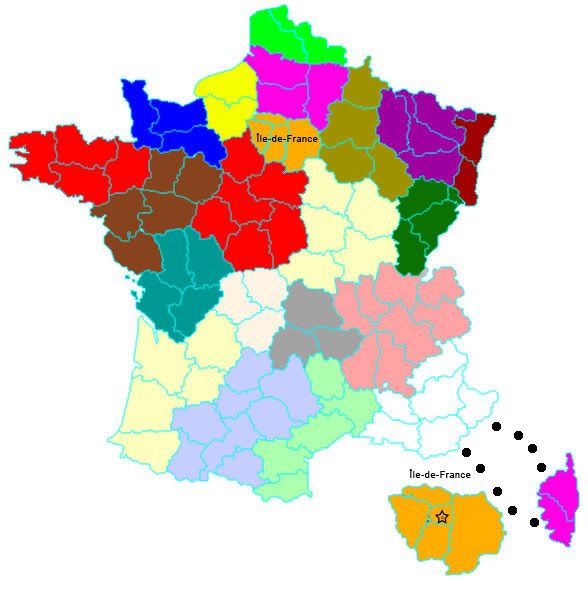
led, the only things i would consider changing so far would be to make the red white and blue of the flag background consistent from top to bottom, rather than changing to purple--kindof looks confusing. also, i can't tell which territories are bordering or not, regarding the 4 territories in Rhône-Alpes that i mentioned a little earlier. i think it would be better to have a blue star than a red one for paris. the red and yellow with a star looks like a communist country's flag. maybe white with a blue star would look nice? it would probably be good to have the lines shown in ile-de-france on the big map so you could see which inner territories border on which ones outside. paris is also further broken up into 4 separate territories--thus making the ile-de-france a veritable island of two surrounding circles of 4 then 3 territories, to help protect the capital at the center. it's a distinctly medieval keep/castle/city walls/outer city/country defense layout--which is also why i really like representing all the departments accurately--you can actually see the strategic thinking of the country's layout. paris itself is even further subdivided into 20 arrondissements (same number of regions) that start from the center and spiral out, and at the center there is an island in the middle of the seine (two actually), the ile de la cité, where the gov't and religious centers of power are--the very very very last refuge. pretty cool :D
http://www.bonjourlafrance.com/france-m ... 1x1167.jpg
it's going to be a headache to design the four extra territories that paris is broken into in the space provided by the map dimensions but i think it is pretty important to (somehow) accurately reflect the strategic design of the city's defenses. with this being the case, maybe it would be justified to make paris worth two, and ile-de-france worth one or two more. perhaps if the relief map was up top, so there could be lines from the innermost territories going to the outside of the box, indicating the names and army count?

i don't want to get ahead of myself here but it would also be really cool (one day) to do a city map of paris with the theme of the french revoloution or the storming of the bastille :D
User avatar
Cadet theallnewbatman
 
Posts: 49
Joined: Mon Jan 26, 2009 9:02 am

Re: A Real Map of France Please

Postby miniwally on Sun Feb 08, 2009 1:45 pm

no point me trying to make one :P the one thingy made is excellent just make ti so you can see what territories attack into ile de france

I'll still probably make it myself though just no point posting them as i doubt they'll look as good as that
User avatar
Private 1st Class miniwally
 
Posts: 257
Joined: Sat Jul 19, 2008 2:56 pm

Re: A Real Map of France Please

Postby theallnewbatman on Sun Feb 08, 2009 2:05 pm

yeah, me either. led's is by far the best of all three. please do continue to give comments and ideas based on what you're working with :D i'd like to get some cartographic software eventually. i really enjoy drawing maps, have done it for years, just never for risk but for rpgs instead.
User avatar
Cadet theallnewbatman
 
Posts: 49
Joined: Mon Jan 26, 2009 9:02 am

Re: A Real Map of France Please

Postby miniwally on Sun Feb 08, 2009 2:10 pm

I just got an idea on what to do for map so i'll post my next one (when i've put my idea on it) when i've done this stage
User avatar
Private 1st Class miniwally
 
Posts: 257
Joined: Sat Jul 19, 2008 2:56 pm

Re: A Real Map of France Please

Postby theallnewbatman on Sun Feb 08, 2009 2:22 pm

"maps for rpgs instead" = by hand, with colored pencil or watercolor on paper
User avatar
Cadet theallnewbatman
 
Posts: 49
Joined: Mon Jan 26, 2009 9:02 am

Re: A Real Map of France Please

Postby miniwally on Sun Feb 08, 2009 2:33 pm

my lan didn't work maybe led can get it to work if he wants to use it.

led why don'y you use coats of arms for each region somewhere possibly i was going to put it behind shape of country and change opacity of the region
User avatar
Private 1st Class miniwally
 
Posts: 257
Joined: Sat Jul 19, 2008 2:56 pm

Re: A Real Map of France Please

Postby theallnewbatman on Sun Feb 08, 2009 4:01 pm

miniwally wrote:led why don'y you use coats of arms for each region somewhere


that's a brilliant idea, wally! the regional flags are beautiful! i'd suggest using the regional flag instead of the coat of arms, because it's more recognizable and easier to familiarize with the region (mostly because one sees the regional flag far more often than the coat of arms). I have to crash early tonight but I will redo the list of borders tomorrow eve and will include a copy of each flag and coat of arms, plus a link to where i got each from.
User avatar
Cadet theallnewbatman
 
Posts: 49
Joined: Mon Jan 26, 2009 9:02 am

Re: A Real Map of France Please

Postby miniwally on Sun Feb 08, 2009 4:08 pm

just go on wikipedia for coat of arms
User avatar
Private 1st Class miniwally
 
Posts: 257
Joined: Sat Jul 19, 2008 2:56 pm

Re: A Real Map of France Please

Postby theallnewbatman on Sun Feb 08, 2009 4:20 pm

same for the flag. thought i'd save y'all the legwork :D cool with me if y'all are cool getting the art yourselves...
User avatar
Cadet theallnewbatman
 
Posts: 49
Joined: Mon Jan 26, 2009 9:02 am

Re: A Real Map of France Please

Postby LED ZEPPELINER on Sun Feb 08, 2009 4:33 pm

for the bonuses, i was thinking of just taking the blob, shrinking it, and putting it to the side (do this with each region) and just write the name +whatever it will be worth
Sergeant LED ZEPPELINER
 
Posts: 1088
Joined: Tue Nov 25, 2008 10:09 pm

Re: A Real Map of France Please

Postby theallnewbatman on Sun Feb 08, 2009 4:35 pm

i think it would be cool to show just the flag for each region, then in the bonus list, show the flag in miniature, the region name, then the number of bonus armies.
User avatar
Cadet theallnewbatman
 
Posts: 49
Joined: Mon Jan 26, 2009 9:02 am

Re: A Real Map of France Please

Postby LED ZEPPELINER on Sun Feb 08, 2009 5:07 pm

theallnewbatman wrote:i think it would be cool to show just the flag for each region, then in the bonus list, show the flag in miniature, the region name, then the number of bonus armies.

oh, i see what your saying, instead of having colors, there are just flags
Sergeant LED ZEPPELINER
 
Posts: 1088
Joined: Tue Nov 25, 2008 10:09 pm

Re: A Real Map of France Please

Postby theallnewbatman on Sun Feb 08, 2009 5:11 pm

yeah, instead of region names or colors... :D
User avatar
Cadet theallnewbatman
 
Posts: 49
Joined: Mon Jan 26, 2009 9:02 am

Re: A Real Map of France Please

Postby Industrial Helix on Sun Feb 08, 2009 5:12 pm

Led, thats a nice map you got. You need to make France bigger though if you want to fit names and armies inside those departments. You could cut out Spain and the med perhaps?
User avatar
Cook Industrial Helix
 
Posts: 3462
Joined: Mon Jul 14, 2008 6:49 pm
Location: Ohio

Re: A Real Map of France Please

Postby LED ZEPPELINER on Sun Feb 08, 2009 5:14 pm

the only problem with that, is how we are going to put territoriy names, it will get hard

edit: and some of the flags blend in together, we could maybe make the region borders darker, or a different color, but it will get tricky
Last edited by LED ZEPPELINER on Sun Feb 08, 2009 5:24 pm, edited 1 time in total.
sailorseal wrote:My big boy banana was out the whole time :D
AndyDufresne wrote:
AndyDufresne wrote:Many Happy Bananas to everyone, lets party...with Bananas.
--Andy
Forever linked at the hip's-banana! (That sounds strange, don't quote me.)
Sergeant LED ZEPPELINER
 
Posts: 1088
Joined: Tue Nov 25, 2008 10:09 pm

PreviousNext

Return to Melting Pot: Map Ideas

Who is online

Users browsing this forum: No registered users