Central America [Quenched]
Moderator: Cartographers
Re: Central America [D] V8 !!
![]() by Incandenza on Sun May 03, 2009 7:34 pm
by Incandenza on Sun May 03, 2009 7:34 pm
Yeah, I think the San Juan - Limon border could be moved a bit west, maybe have it come down from that little dip in the rio san jose border...
THOTA: dingdingdingdingdingdingBOOM
Te Occidere Possunt Sed Te Edere Non Possunt Nefas Est
Te Occidere Possunt Sed Te Edere Non Possunt Nefas Est
-

 Incandenza
- Posts: 4949
- Joined: Thu Oct 19, 2006 5:34 pm
- Location: Playing Eschaton with a bucket of old tennis balls


Re: Central America [D] V8 !!
![]() by lgoasklucyl on Sun May 03, 2009 8:23 pm
by lgoasklucyl on Sun May 03, 2009 8:23 pm
Incandenza wrote:Yeah, I think the San Juan - Limon border could be moved a bit west, maybe have it come down from that little dip in the rio san jose border...
Ah- a brilliant solution that doesn't involve making sea levels fictionally rise; thanks!!!!!

-

lgoasklucyl
- Posts: 526
- Joined: Mon Apr 07, 2008 8:49 pm
- Location: Somewhere in the 20th century.


Re: Central America [D] V8 !!
![]() by Incandenza on Sun May 03, 2009 8:28 pm
by Incandenza on Sun May 03, 2009 8:28 pm
No problemo!
THOTA: dingdingdingdingdingdingBOOM
Te Occidere Possunt Sed Te Edere Non Possunt Nefas Est
Te Occidere Possunt Sed Te Edere Non Possunt Nefas Est
-
Incandenza
- Posts: 4949
- Joined: Thu Oct 19, 2006 5:34 pm
- Location: Playing Eschaton with a bucket of old tennis balls
Re: Central America [D] V8 !!
![]() by oaktown on Mon May 04, 2009 12:12 am
by oaktown on Mon May 04, 2009 12:12 am
just so you don't go thinking I'm letting you do all the work around here... still to do are replacing accents with unicode characters (so we don't freak out the site/BOB) and coordinates.
- Code: Select all
<?xml version="1.0"?>
<map>

    <title>Central America</title>
    <smallwidth>630</smallwidth>
    <smallheight>600</smallheight>
    <largewidth>840</largewidth>
    <largeheight>800</largeheight>
    <filetype>jpg</filetype>

<positions>
   <position>
      <territory>San Salvador</territory>
   </position>
   <position>
      <territory>Usulután</territory>
   </position>
</positions>

<continent>
      <name>Guatemala</name>
      <bonus>3</bonus>
      <components>
         <territory>Petén</territory>
         <territory>Izabal</territory>
         <territory>Quiché</territory>
         <territory>Xela</territory>
         <territory>Guatemala</territory>
      </components>
</continent>
         <!---->
<continent>
      <name>Belize</name>
      <bonus>1</bonus>
      <components>
         <territory>Orange Walk</territory>
         <territory>The Cayes</territory>
         <territory>Belmopan</territory>
      </components>
</continent>
         <!---->
<continent>
      <name>Honduras</name>
      <bonus>4</bonus>
      <components>
         <territory>Copán</territory>
         <territory>Alténtida</territory>
         <territory>Islas de la Bahia</territory>
         <territory>Tegucigalpa</territory>
         <territory>Olancho</territory>
         <territory>Colón</territory>
      </components>
</continent>
         <!---->
<continent>
      <name>El Salvador</name>
      <bonus>1</bonus>
      <components>
         <territory>San Salvador</territory>
         <territory>Usulután</territory>
      </components>
</continent>
         <!---->
<continent>
      <name>Nicaragua</name>
      <bonus>5</bonus>
      <components>
         <territory>RAAN</territory>
         <territory>Jinotega</territory>
         <territory>Chinandega</territory>
         <territory>Managua</territory>
         <territory>Boaca</territory>
         <territory>RAAS</territory>
         <territory>Rio San Juan</territory>
      </components>
</continent>
         <!---->
<continent>
      <name>Panama</name>
      <bonus>3</bonus>
      <components>
         <territory>Darien Gap</territory>
         <territory>Canál</territory>
         <territory>Bocas del Toro</territory>
         <territory>Chiriqui</territory>
         <territory>Coclé</territory>
      </components>
</continent>
         <!---->
<continent>
      <name>Costa Rica</name>
      <bonus>3</bonus>
      <components>
         <territory>Limón</territory>
         <territory>Puntarenas</territory>
         <territory>San Jose</territory>
      </components>
</continent>

<continent>
      <name>Shipping Lanes</name>
      <bonus>3</bonus>
      <components>
         <territory>Canál</territory>
         <territory>Pacific Sea Route</territory>
         <territory>Atlantic Sea Route</territory>
      </components>
</continent>

<!-- Beginning of Territories -->
<territory>
      <name>Orange Walk</name>
      <borders>
         <border>The Cayes</border>
         <border>Belmopan</border>
         <border>Petén</border>
      </borders>
      <coordinates>
         <smallx>1</smallx>
         <smally>1</smally>
         <largex>1</largex>
         <largey>1</largey>
      </coordinates>
</territory>
      <!---->
<territory>
      <name>The Cayes</name>
      <borders>
         <border>Orange Walk</border>
         <border>Belmopan</border>
      </borders>
      <coordinates>
         <smallx>1</smallx>
         <smally>1</smally>
         <largex>1</largex>
         <largey>1</largey>
      </coordinates>
</territory>
      <!---->
<territory>
      <name>Belmopan</name>
      <borders>
         <border>The Cayes</border>
         <border>Orange Walk</border>
         <border>Petén</border>
         <border>Izabal</border>
      </borders>
      <coordinates>
         <smallx>1</smallx>
         <smally>1</smally>
         <largex>1</largex>
         <largey>1</largey>
      </coordinates>
</territory>
      <!---->
<territory>
      <name>Petén</name>
      <borders>
         <border>Orange Walk</border>
         <border>Belmopan</border>
         <border>Izabal</border>
         <border>Quiché</border>
      </borders>
      <coordinates>
         <smallx>1</smallx>
         <smally>1</smally>
         <largex>1</largex>
         <largey>1</largey>
      </coordinates>
</territory>
      <!---->
<territory>
      <name>Izabal</name>
      <borders>
         <border>Belmopan</border>
         <border>Petén</border>
         <border>Quiché</border>
         <border>Guatemala</border>
         <border>Copán</border>
      </borders>
      <coordinates>
         <smallx>1</smallx>
         <smally>1</smally>
         <largex>1</largex>
         <largey>1</largey>
      </coordinates>
</territory>
      <!---->
<territory>
      <name>Quiché</name>
      <borders>
         <border>Xela</border>
         <border>Petén</border>
         <border>Izabal</border>
         <border>Guatemala</border>
      </borders>
      <coordinates>
         <smallx>1</smallx>
         <smally>1</smally>
         <largex>1</largex>
         <largey>1</largey>
      </coordinates>
</territory>
      <!---->
<territory>
      <name>Guatemala</name>
      <borders>
         <border>Xela</border>
         <border>Quiché</border>
         <border>Izabal</border>
         <border>Copán</border>
         <border>San Salvador</border>
         <border>Pacific Sea Route</border>
      </borders>
      <coordinates>
         <smallx>1</smallx>
         <smally>1</smally>
         <largex>1</largex>
         <largey>1</largey>
      </coordinates>
</territory>
      <!---->
<territory>
      <name>Xela</name>
      <borders>
         <border>Quiché</border>
         <border>Guatemala</border>
      </borders>
      <coordinates>
         <smallx>1</smallx>
         <smally>1</smally>
         <largex>1</largex>
         <largey>1</largey>
      </coordinates>
</territory>
      <!---->
<territory>
      <name>San Salvador</name>
      <borders>
         <border>Guatemala</border>
         <border>Copán</border>
         <border>Usulután</border>
      </borders>
      <coordinates>
         <smallx>1</smallx>
         <smally>1</smally>
         <largex>1</largex>
         <largey>1</largey>
      </coordinates>
</territory>
      <!---->
<territory>
      <name>Usulután</name>
      <borders>
         <border>San Salvador</border>
         <border>Copán</border>
         <border>Tegucigalpa</border>
      </borders>
      <coordinates>
         <smallx>1</smallx>
         <smally>1</smally>
         <largex>1</largex>
         <largey>1</largey>
      </coordinates>
</territory>
      <!---->
<territory>
      <name>Copán</name>
      <borders>
         <border>Izabal</border>
         <border>Atlantic Sea Route</border>
         <border>Alténtida</border>
         <border>Tegucigalpa</border>
         <border>Usulután</border>
         <border>San Salvador</border>
         <border>Guatemala</border>
      </borders>
      <coordinates>
         <smallx>1</smallx>
         <smally>1</smally>
         <largex>1</largex>
         <largey>1</largey>
      </coordinates>
</territory>
      <!---->
<territory>
      <name>Alténtida</name>
      <borders>
         <border>Islas de la Bahia</border>
         <border>Colón</border>
         <border>Olancho</border>
         <border>Tegucigalpa</border>
         <border>Copán</border>
      </borders>
      <coordinates>
         <smallx>1</smallx>
         <smally>1</smally>
         <largex>1</largex>
         <largey>1</largey>
      </coordinates>
</territory>
      <!---->
<territory>
      <name>Islas de la Bahia</name>
      <borders>
         <border>Alténtida</border>
         <border>Colón</border>
      </borders>
      <coordinates>
         <smallx>1</smallx>
         <smally>1</smally>
         <largex>1</largex>
         <largey>1</largey>
      </coordinates>
</territory>
      <!---->
<territory>
      <name>Tegucigalpa</name>
      <borders>
         <border>Copán</border>
         <border>Alténtida</border>
         <border>Olancho</border>
         <border>Jinotega</border>
         <border>Chinandega</border>
         <border>Usulután</border>
      </borders>
      <coordinates>
         <smallx>1</smallx>
         <smally>1</smally>
         <largex>1</largex>
         <largey>1</largey>
      </coordinates>
</territory>
      <!---->
<territory>
      <name>Olancho</name>
      <borders>
         <border>Alténtida</border>
         <border>Colón</border>
         <border>RAAN</border>
         <border>Jinotega</border>
         <border>Tegucigalpa</border>
      </borders>
      <coordinates>
         <smallx>1</smallx>
         <smally>1</smally>
         <largex>1</largex>
         <largey>1</largey>
      </coordinates>
</territory>
      <!---->
<territory>
      <name>Colón</name>
      <borders>
         <border>Alténtida</border>
         <border>Islas de la Bahia</border>
         <border>RAAN</border>
         <border>Olancho</border>
      </borders>
      <coordinates>
         <smallx>1</smallx>
         <smally>1</smally>
         <largex>1</largex>
         <largey>1</largey>
      </coordinates>
</territory>
      <!---->
<territory>
      <name>RAAN</name>
      <borders>
         <border>Colón</border>
         <border>RAAS</border>
         <border>Jinotega</border>
         <border>Olancho</border>
      </borders>
      <coordinates>
         <smallx>1</smallx>
         <smally>1</smally>
         <largex>1</largex>
         <largey>1</largey>
      </coordinates>
</territory>
      <!---->
<territory>
      <name>Jinotega</name>
      <borders>
         <border>RAAN</border>
         <border>RAAS</border>
         <border>Boaca</border>
         <border>Chinandega</border>
         <border>Tegucigalpa</border>
         <border>Olancho</border>
      </borders>
      <coordinates>
         <smallx>1</smallx>
         <smally>1</smally>
         <largex>1</largex>
         <largey>1</largey>
      </coordinates>
</territory>
      <!---->
<territory>
      <name>Chinandega</name>
      <borders>
         <border>Tegucigalpa</border>
         <border>Jinotega</border>
         <border>Boaca</border>
         <border>Managua</border>
      </borders>
      <coordinates>
         <smallx>1</smallx>
         <smally>1</smally>
         <largex>1</largex>
         <largey>1</largey>
      </coordinates>
</territory>
      <!---->
<territory>
      <name>Managua</name>
      <borders>
         <border>Chinandega</border>
         <border>Boaca</border>
         <border>San Jose</border>
      </borders>
      <coordinates>
         <smallx>1</smallx>
         <smally>1</smally>
         <largex>1</largex>
         <largey>1</largey>
      </coordinates>
</territory>
      <!---->
<territory>
      <name>Boaca</name>
      <borders>
         <border>Jinotega</border>
         <border>RAAS</border>
         <border>Rio San Juan</border>
         <border>Managua</border>
         <border>Chinandega</border>
      </borders>
      <coordinates>
         <smallx>1</smallx>
         <smally>1</smally>
         <largex>1</largex>
         <largey>1</largey>
      </coordinates>
</territory>
      <!---->
<territory>
      <name>RAAS</name>
      <borders>
         <border>RAAN</border>
         <border>Rio San Juan</border>
         <border>Boaca</border>
         <border>Jinotega</border>
      </borders>
      <coordinates>
         <smallx>1</smallx>
         <smally>1</smally>
         <largex>1</largex>
         <largey>1</largey>
      </coordinates>
</territory>
      <!---->
<territory>
      <name>Rio San Juan</name>
      <borders>
         <border>Boaca</border>
         <border>RAAS</border>
         <border>Limón</border>
         <border>San Jose</border>
         <border>Atlantic Sea Route</border>
      </borders>
      <coordinates>
         <smallx>1</smallx>
         <smally>1</smally>
         <largex>1</largex>
         <largey>1</largey>
      </coordinates>
</territory>
       <!---->
<territory>
      <name>San Jose</name>
      <borders>
         <border>Managua</border>
         <border>Rio San Juan</border>
         <border>Limón</border>
         <border>Puntarenas</border>
      </borders>
      <coordinates>
         <smallx>1</smallx>
         <smally>1</smally>
         <largex>1</largex>
         <largey>1</largey>
      </coordinates>
</territory>     <!---->
<territory>
      <name>Puntarenas</name>
      <borders>
         <border>San Jose</border>
         <border>Limón</border>
         <border>Bocas del Toro</border>
         <border>Chiriqui</border>
         <border>Pacific Sea Route</border>
      </borders>
      <coordinates>
         <smallx>1</smallx>
         <smally>1</smally>
         <largex>1</largex>
         <largey>1</largey>
      </coordinates>
</territory>
      <!---->
<territory>
      <name>Limón</name>
      <borders>
         <border>Rio San Juan</border>
         <border>San Jose</border>
         <border>Puntarenas</border>
         <border>Bocas del Toro</border>
      </borders>
      <coordinates>
         <smallx>1</smallx>
         <smally>1</smally>
         <largex>1</largex>
         <largey>1</largey>
      </coordinates>
</territory>
      <!---->
<territory>
      <name>Chiriqui</name>
      <borders>
         <border>Puntarenas</border>
         <border>Bocas del Toro</border>
         <border>Coclé</border>
      </borders>
      <coordinates>
         <smallx>1</smallx>
         <smally>1</smally>
         <largex>1</largex>
         <largey>1</largey>
      </coordinates>
</territory>
      <!---->
<territory>
      <name>Bocas del Toro</name>
      <borders>
         <border>Limón</border>
         <border>Puntarenas</border>
         <border>Chiriqui</border>
         <border>Coclé</border>
         <border>Canál</border>
      </borders>
      <coordinates>
         <smallx>1</smallx>
         <smally>1</smally>
         <largex>1</largex>
         <largey>1</largey>
      </coordinates>
</territory>
      <!---->
<territory>
      <name>Coclé</name>
      <borders>
         <border>Chiriqui</border>
         <border>Bocas del Toro</border>
         <border>Canál</border>
      </borders>
      <coordinates>
         <smallx>1</smallx>
         <smally>1</smally>
         <largex>1</largex>
         <largey>1</largey>
      </coordinates>
</territory>
      <!---->
<territory>
      <name>Canál</name>
      <borders>
         <border>Bocas del Toro</border>
         <border>Coclé</border>
         <border>Darien Gap</border>
         <border>Pacific Sea Route</border>
         <border>Atlantic Sea Route</border>
      </borders>
      <coordinates>
         <smallx>1</smallx>
         <smally>1</smally>
         <largex>1</largex>
         <largey>1</largey>
      </coordinates>
</territory>
      <!---->
<territory>
      <name>Darien Gap</name>
      <borders>
         <border>Canál</border>
      </borders>
      <coordinates>
         <smallx>1</smallx>
         <smally>1</smally>
         <largex>1</largex>
         <largey>1</largey>
      </coordinates>
</territory>
      <!---->
<territory>
      <name>Pacific Sea Route</name>
      <borders>
         <border>Canál</border>
         <border>Puntarenas</border>
         <border>Guatemala</border>
      </borders>
      <coordinates>
         <smallx>1</smallx>
         <smally>1</smally>
         <largex>1</largex>
         <largey>1</largey>
      </coordinates>
</territory>
      <!---->
<territory>
      <name>Atlantic Sea Route</name>
      <borders>
         <border>Canál</border>
         <border>Copán</border>
         <border>Rio San Juan</border>
      </borders>
      <coordinates>
         <smallx>1</smallx>
         <smally>1</smally>
         <largex>1</largex>
         <largey>1</largey>
      </coordinates>
</territory>
</map>

-

oaktown
- Posts: 4451
- Joined: Sun Dec 03, 2006 9:24 pm
- Location: majorcommand


Re: Central America [D] V8 !!
![]() by maritovw on Mon May 04, 2009 2:45 am
by maritovw on Mon May 04, 2009 2:45 am
my native language is spanish, and i have a couple corrections...
great map by the way!! i'm looking forward to it!
- "Canál" is misspelled, it should be "Canal", without the accent on the last "a" ...
- "Rio San Juan" is misspelled, it shoud be "Río", with the accent on the "i"
- "Islas de la Bahia" is misspelled, it should be "Bahía", with the accent on the last "i"
- If you are spelling the country names in spanish, "Panama" should have an accent on the last "a", "Panamá"
great map by the way!! i'm looking forward to it!
 MIDDLE AMERICA MAP
-

maritovw
- Posts: 195
- Joined: Mon Jul 17, 2006 10:05 pm
- Location: Guatemala

Re: Central America [D] V8 !!
![]() by lgoasklucyl on Mon May 04, 2009 11:17 am
by lgoasklucyl on Mon May 04, 2009 11:17 am
maritovw wrote:my native language is spanish, and i have a couple corrections...also, i'm from Guatemala and "Xela" is just a short name for a city named "Xelajú", so i think you should rename that territory (i mentioned this a long time ago, but it was never addressed)...
- "Canál" is misspelled, it should be "Canal", without the accent on the last "a" ...
- "Rio San Juan" is misspelled, it shoud be "Río", with the accent on the "i"
- "Islas de la Bahia" is misspelled, it should be "Bahía", with the accent on the last "i"
- If you are spelling the country names in spanish, "Panama" should have an accent on the last "a", "Panamá"
great map by the way!! i'm looking forward to it!
I have made a note of all of these changes and they will be in the next update- thanks for catching them for us
-
lgoasklucyl
- Posts: 526
- Joined: Mon Apr 07, 2008 8:49 pm
- Location: Somewhere in the 20th century.
Re: Central America [D] V7; big changes! (p. 1 and 8!!)
![]() by iancanton on Tue May 05, 2009 4:55 pm
by iancanton on Tue May 05, 2009 4:55 pm
Incandenza wrote:While adding a terit to el salvador isn't a bad idea, I tend to think that nicaragua can stay the way it is... given the sea lanes, this'll be a pretty easy map to move around in
lgoasklucyl wrote:iancanton wrote:anyone who starts in nicaragua is at an obvious disadvantage: as well as being stuck in the middle of the map, it isn't next to a tiny bonus. we can reduce this disadvantage by merging 4 of nicaragua's regions into 2 (merge RAAN with RAAS and jinotega with chinandega, perhaps?).
The bonus would probably need to be slightly reduce in this instance, no? While it can still be attack via sea routes, it would only have 2 borders in the north and south, and if someone held the bonuses 6 total. Unsure where to go with this one. Personally, I think I've grown to like the blob in the center of the map.
yes, i did mean with a reduced nicaragua bonus, though we now have good support for an unchanged nicaragua bonus zone.
lgoasklucyl wrote:iancanton wrote:i also think there would be fewer starting issues if the 2-region el salvador bonus became a 3-region one by adding santa ana in western el salvador (the san salvador troop count can be moved sotuh-east, with the name can going in the sea).
I kind of like the smaller bonuses, so a +2 doesn't give too much away if held for one turn. Are you proposing that the 3rd territ be locked in by the other two? In that instance it may work. (ie: Santa ana and Usultan are borders with San Salvador resting further to the west).
yes, where santa ana and usultan are border regions, with non-border san salvador located on the coast.
oaktown wrote:I think it might be worthwhile to code El Salvador as starting positions.
in my opinion, where we have 3-region bonus zones, we ought to avoid having a 2-region bonus zone too unless it's graphically necessary, since using start positions doesn't work well in such cases in a 2v2 game. i therefore recommend making el salvador a 3-region bonus zone.
lgoasklucyl wrote:iancanton wrote:to restore the starting count of 32 regions, an extra one in guatemala reduces the existing benefit of staring in the north (in 4-player singles, it's always nice to start at one end of a linear map, especially next to two easy bonuses).
I do like this suggestion, is there a geographical way to do this?
my guatamala geography isn't good enough! the country seems to be one big city with lots of little villages. maybe maritovw might have an idea for an extra region if u decide that u want to do this?
ian.

-

iancanton
- Foundry Foreman

- Posts: 2451
- Joined: Fri Jun 01, 2007 5:40 am
- Location: europe


Re: Central America [D] V8 !!
![]() by RjBeals on Tue May 05, 2009 5:20 pm
by RjBeals on Tue May 05, 2009 5:20 pm
lg - did you still wanna chat about the minimap?

-

RjBeals
- Posts: 2506
- Joined: Mon Nov 20, 2006 5:17 pm
- Location: South Carolina, USA


Re: Central America [D] V8 (p.1+9) !!!!!
![]() by Elegarth on Tue May 05, 2009 5:35 pm
by Elegarth on Tue May 05, 2009 5:35 pm
lgoasklucyl wrote:Version 8
-Deleted the Guanacaste/San Jose border to make it one territ for a 3 territ +2 bonus; looks kind of ugly though- should I bring the actual land in from the ocean more so it's not such a huge blob? Also, should the name stay San Jose, Guanacaste, or something to encompass both (no idea what the third would be)
I am not good at map making and I usually don't take much time to post here, but I might help with it.
Guanacaste, Limon and Puntarenas names are fair enough since they are more similar to the actual division that you are making. Costa Rica is more or less divided into four regions for many considerations, but maps need not relate to real life. Just a FYI, is more or less like this (and don't kill me for my lack of drawing and paint skills, I suck at this):

Where
1= Great Metropolitan Area = What you could call SAN JOSE
2= Pacific Coastline = What you could call PUNTARENAS
3= North Pacific Coastline = What you could call GUANACASTE
4 = Atlantic Coastline = What you could call LIMON
So, you can work out of it. If you'd rather leave it in 3 territories, you might rather draw a line down from Rio San Juan, like this:

(Don't kill me for lack of skills please). Remains to be seen what could be done regarding gameplay, where my opinion actually fails. And if you just decide to leave it as it is, then name them Guanacaste, Limon and Puntarenas since San Jose really doesn't match any of those regions
Hope I have been of some assistance
(also note that the original map I wrote over shows several more regions, but nevermind them since CR is too smal a region to further divide it in a CC map)
-

Elegarth
- Posts: 65
- Joined: Sat Jul 14, 2007 6:48 pm


Re: Central America [D] V8 !!
![]() by lgoasklucyl on Tue May 05, 2009 5:42 pm
by lgoasklucyl on Tue May 05, 2009 5:42 pm
http://img.photobucket.com/albums/v321/SephSlayer/cr.jpg
Thanks you SO much, this is exactly what I needed regarding these regions! I was curious as to what would make better sense in the region, and you cleared it up very nicely
RjBeals wrote:lg - did you still wanna chat about the minimap?
Yeah, just a couple things, really:
1. The font you used, as it may work with the overall map better than the one I've chosen.
2. How did you copy the land over and get the stroke to look so neat? I tried duplicating just the territory color layers and resizing them, but they don't look too hot how I did it. Also, your stroke looks MUCH neater than what I came up with.
Iancanton wrote:in my opinion, where we have 3-region bonus zones, we ought to avoid having a 2-region bonus zone too unless it's graphically necessary, since using start positions doesn't work well in such cases in a 2v2 game. i therefore recommend making el salvador a 3-region bonus zone.
-This still definitely applies as an option if others show interest! Two region bonuses can be a pain in the ass, and three may be the solution we need. Gotta see if anyone else feels it's the way to go or not
Thanks everyone! Lots of advice/errors I can use to pour out the next draft
-
lgoasklucyl
- Posts: 526
- Joined: Mon Apr 07, 2008 8:49 pm
- Location: Somewhere in the 20th century.
Re: Central America [D] V8 !!
![]() by Elegarth on Tue May 05, 2009 5:43 pm
by Elegarth on Tue May 05, 2009 5:43 pm
No problem. I have lived here for 25 years so... 
-
Elegarth
- Posts: 65
- Joined: Sat Jul 14, 2007 6:48 pm
Re: Central America [D] V8 !!
![]() by Incandenza on Tue May 05, 2009 7:15 pm
by Incandenza on Tue May 05, 2009 7:15 pm
lgoasklucyl wrote:-This still definitely applies as an option if others show interest! Two region bonuses can be a pain in the ass, and three may be the solution we need. Gotta see if anyone else feels it's the way to go or not
I can definitely get on board with adding a non-border terit to el sal.
THOTA: dingdingdingdingdingdingBOOM
Te Occidere Possunt Sed Te Edere Non Possunt Nefas Est
Te Occidere Possunt Sed Te Edere Non Possunt Nefas Est
-
Incandenza
- Posts: 4949
- Joined: Thu Oct 19, 2006 5:34 pm
- Location: Playing Eschaton with a bucket of old tennis balls
Re: Central America [D] V8 !!
![]() by oaktown on Wed May 06, 2009 1:14 am
by oaktown on Wed May 06, 2009 1:14 am
my two cents...
I see some talk of adding a territory to guatemala to "restore" the map to 32 territories, but I think it should be pointed out that the map currently has 33 nterritories. We began with 32, but added the sea routes, then dropped a territory in Costa Rica. 33. And just in case I counted them.
I'm personally quite comfortable with El Salvador having just two territories. When we hashed this out month ago the logic was that once you secure the country it's not exactly as if you will take over the map. A +1 isn't devastating, there is no easy expansion from El Salvador, and you're sure to have somebody next to you ready to take you out right quick. Personally if I started there in a game I might grab the bonus, but then defend it minimally and use my armies elsewhere. Even Belize is a better start because you can expand into Guatemala and minimize your borders.
There are possible fixes other than adding a territory. We could expand to eight starting positions, but the trouble with this is that it actually increases the chances of dropping El Salvador in 1v1 games. A better solution would be to scrap the starting territories and just start one of the El Salvador territories neutral; with 33 terits there is going to be at least one neutral in 2, 4, 5, 6, 7, and 8 player games anyway. This would bring the map back to the original 32, which means that in 1v1 and 3 player games a player needs two takes, not just one, to get up to 12 territories and that one extra army - a bonus effect. As a neutral territory the player who starts there would have to ask himself if it's worth a +1 bonus to waste his first turn hitting neutral armies.
-
oaktown
- Posts: 4451
- Joined: Sun Dec 03, 2006 9:24 pm
- Location: majorcommand
Re: Central America [D] V8 !!
![]() by AndyDufresne on Wed May 06, 2009 2:19 pm
by AndyDufresne on Wed May 06, 2009 2:19 pm
I'd be fine with El Salvador starting neutral---but I kind of like the chance of getting lucky drop/taking out a player's troops if I've got troops in the adjacent territory.
--Andy
--Andy
-

AndyDufresne
- Posts: 24935
- Joined: Fri Mar 03, 2006 8:22 pm
- Location: A Banana Palm in Zihuatanejo


Re: Central America [D] V8 !!
![]() by lgoasklucyl on Wed May 06, 2009 2:55 pm
by lgoasklucyl on Wed May 06, 2009 2:55 pm
AndyDufresne wrote:I'd be fine with El Salvador starting neutral---but I kind of like the chance of getting lucky drop/taking out a player's troops if I've got troops in the adjacent territory.
--Andy
Would starting all of El Salvador neutral solve anything? That would just result in Belize being a far more favorable bonus.
Strategy-wise, good team players are far more likely to go for the three terit bonus if it means taking another players troops out than a 2 territ, neutral bonus where they could lose troops taking no one elses.
I think if anything is to be done it should be the third, non-border territory personally.
-
lgoasklucyl
- Posts: 526
- Joined: Mon Apr 07, 2008 8:49 pm
- Location: Somewhere in the 20th century.
Re: Central America [D] V8 !!
![]() by AndyDufresne on Wed May 06, 2009 3:00 pm
by AndyDufresne on Wed May 06, 2009 3:00 pm
What if the sea route was neutral? I'd like to see a neutral free mainland.
--Andy
--Andy
-
AndyDufresne
- Posts: 24935
- Joined: Fri Mar 03, 2006 8:22 pm
- Location: A Banana Palm in Zihuatanejo
Re: Central America [D] V8 !!
![]() by Incandenza on Wed May 06, 2009 3:40 pm
by Incandenza on Wed May 06, 2009 3:40 pm
If given the choice, I'd rather see A) a 3-terit el sal or B) a 2-terit el sal with 1 neutral, than a neutral in one of the sea lanes...
THOTA: dingdingdingdingdingdingBOOM
Te Occidere Possunt Sed Te Edere Non Possunt Nefas Est
Te Occidere Possunt Sed Te Edere Non Possunt Nefas Est
-
Incandenza
- Posts: 4949
- Joined: Thu Oct 19, 2006 5:34 pm
- Location: Playing Eschaton with a bucket of old tennis balls
Re: Central America [D] V8 !!
![]() by lgoasklucyl on Wed May 06, 2009 4:30 pm
by lgoasklucyl on Wed May 06, 2009 4:30 pm
Incandenza wrote:If given the choice, I'd rather see A) a 3-terit el sal or B) a 2-terit el sal with 1 neutral, than a neutral in one of the sea lanes...
I personally favor option a very, VERY highly in this situation.
I'm telling everyone now- if one of the territs in a two territ bonus starts neutral it will rarely be used. If anything is neutral in a bonus, it should grant at least an extra +1 to merit being grabbed by an experienced team player.
The only thing I wouldn't mind seeing neutral would be the sea routes, as at least those may NEED to be held to move somewhere.
Maybe I'll poll it with the next version- people LOVE polls
-
lgoasklucyl
- Posts: 526
- Joined: Mon Apr 07, 2008 8:49 pm
- Location: Somewhere in the 20th century.
Re: Central America [D] V8 !!
![]() by iancanton on Thu May 07, 2009 5:22 pm
by iancanton on Thu May 07, 2009 5:22 pm
lgoasklucyl wrote:I'm telling everyone now- if one of the territs in a two territ bonus starts neutral it will rarely be used. If anything is neutral in a bonus, it should grant at least an extra +1 to merit being grabbed by an experienced team player.
i tend to agree. el salvador has to be at least a +2 bonus, whether it has 3 regions (with start positions) or 2 regions (with starting neutrals on 1 region). aesthetically, i prefer a 3-region el salvador.
ian.
-
iancanton
- Foundry Foreman
- Posts: 2451
- Joined: Fri Jun 01, 2007 5:40 am
- Location: europe
Re: Central America [D] V8 !!
![]() by AndyDufresne on Thu May 07, 2009 6:53 pm
by AndyDufresne on Thu May 07, 2009 6:53 pm
lgoasklucyl wrote:I'm telling everyone now- if one of the territs in a two territ bonus starts neutral it will rarely be used. If anything is neutral in a bonus, it should grant at least an extra +1 to merit being grabbed by an experienced team player.
Agreed with lgoasklucyl wholeheartedly.
--Andy
-
AndyDufresne
- Posts: 24935
- Joined: Fri Mar 03, 2006 8:22 pm
- Location: A Banana Palm in Zihuatanejo
Re: Central America [D] V8 (Gameplay Poll!!!!!)
![]() by lgoasklucyl on Thu May 07, 2009 7:05 pm
by lgoasklucyl on Thu May 07, 2009 7:05 pm
Thanks Ian and Andy for the support- I added the poll to see what everyone else thinks (we all know people love polls here in the foundry  ).
).
Vote everyone!
I have to huge exams tomorrow, so I won't be pouring out a new version probably until early next week (a bunch of commencement coverage for the paper this weekend/moving out and whatnot), but would like to include this gameplay change (if supported) in version 9 =)
Thanks!
Vote everyone!
I have to huge exams tomorrow, so I won't be pouring out a new version probably until early next week (a bunch of commencement coverage for the paper this weekend/moving out and whatnot), but would like to include this gameplay change (if supported) in version 9 =)
Thanks!
-
lgoasklucyl
- Posts: 526
- Joined: Mon Apr 07, 2008 8:49 pm
- Location: Somewhere in the 20th century.
Re: Central America [D] V8 !!
![]() by oaktown on Thu May 14, 2009 12:57 am
by oaktown on Thu May 14, 2009 12:57 am
lgoasklucyl wrote:I'm telling everyone now- if one of the territs in a two territ bonus starts neutral it will rarely be used. If anything is neutral in a bonus, it should grant at least an extra +1 to merit being grabbed by an experienced team player.
I've played the Berlin map quite a lot, and the neutral airfields are almost always taken... and those are a +1 deployed to the territories, which is not nearly as beneficial as a traditional +1 bonus. If I were to drop Usultan and three neutrals stood between me and a quick bonus on a small map, I'd hit it - especially if i had one of the three territories surrounding from which I could bring in reinforcements.
I should also note that in 1v1 games (which is really where the problems lie) there will be 11 neutrals on the board regardless of whether or not we predetermine where one of them will go.
AndyDufresne wrote:I'd be fine with El Salvador starting neutral---but I kind of like the chance of getting lucky drop/taking out a player's troops if I've got troops in the adjacent territory.
Since we've gone starting-bonus-probability crazy in the past two weeks (maybe we should worry about this stuff just a bit less?) there's about a 10% chance of somebody starting with El Salvador in a 1v1 or 3 player game, and about a 3% chance of somebody starting with the canal/shipping lane bonus. I'd prefer not to see the ships go neutral because 33 (or even 32) makes for nice starts; 31 not so much.
10% is a bit high, and folks hate neutrals. Alternatively, we can code just two starting positions for 1v1 games to keep one player from dropping both. Coding just two start positions won't change the # of starting territories/player - it'll remain 11 territories each. There would be no effect on larger games, but in larger games it's less of an issue - its much harder to hold a bonus against two (or more) enemies than against one, and the odds of dropping it go down - about 5% with 4 players, less than 3% with five players, etc.
-
oaktown
- Posts: 4451
- Joined: Sun Dec 03, 2006 9:24 pm
- Location: majorcommand
Re: Central America [D] V8 (Poll not working-Discuss gameplay!!)
![]() by MrBenn on Tue May 26, 2009 5:48 pm
by MrBenn on Tue May 26, 2009 5:48 pm
Fly to El Salvador,
I don't know why, and I don't know what for;
I've seen the picture for myself.
Where did that label go?
I tried it out but it didn't work, so
I'll choose the picture for myself.
I don't know why, and I don't know what for;
I've seen the picture for myself.
Where did that label go?
I tried it out but it didn't work, so
I'll choose the picture for myself.

PB: 2661 | He's blue... If he were green he would die | No mod would be stupid enough to do that
-

MrBenn
- Posts: 6880
- Joined: Wed Nov 21, 2007 9:32 am
- Location: Off Duty


Re: Central America [D] V8 !!
![]() by iancanton on Thu May 28, 2009 3:17 pm
by iancanton on Thu May 28, 2009 3:17 pm
perhaps belmopan region ought to be renamed belize city. belmopan is the capital, but belize city is ten times the size.
http://www.belizediscover.com/Belmopan.htm
http://www.belizediscover.com/BelizeCity.htm
rename guatemala region as guatemala city to distinguish it from the bonus zone of that name.
ian.
http://www.belizediscover.com/Belmopan.htm
http://www.belizediscover.com/BelizeCity.htm
rename guatemala region as guatemala city to distinguish it from the bonus zone of that name.
ian.
-
iancanton
- Foundry Foreman
- Posts: 2451
- Joined: Fri Jun 01, 2007 5:40 am
- Location: europe
Re: Central America [D] V7; big changes! (p. 1 and 8!!)
![]() by lostatlimbo on Thu May 28, 2009 9:36 pm
by lostatlimbo on Thu May 28, 2009 9:36 pm
having just returned from an extended trip through parts of Central America, i was glad to see that this map is progressing so well.
one thing stands out to me - Quiche (in Guatemala) isn't really indicative of that region. I think what you are looking for is "Las Verapaces" - the proper name for the region (which is home to Semuc Champey - a beautiful national landmark).
other than the name change above, the regions are fairly accurate. the only thing i see missing is the Pacific slope. on the map, it would cut Xela in half and take a chunk of Guatemala City too. geographically, this is a very different region from elsewhere in the country as the highlands quickly drop off to the Pacific Ocean.
HOWEVER...
Belize is much more lacking. rather than renaming Belmopan to Belize City, there should be 4 regions - the Cayes to the east, Orange Walk in the north, Belize City in the middle and Cayo in the south.
most of southern belize is thick, uninhabited jungle. to call that whole region either Belmopan or Belize City is misrepresenting half the country. the road connecting those two cities essentially splits the country in half and neither of them are anywhere near the Izabal region of Guatemala.
if you make some space in the middle and make they Cayes connect only to Orange Walk and the new Belize City territory, you'll have it just right and get that extra territory you're looking for.
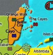
Mock up for visual reference
and a real Belize map that better illustrates my point
http://www.moon.com/files/map-images/bel_00_Belize.jpg
this perplexes me. the actual name of Xela is actually Quetzaltenango. Xelaju is the old Mayan name for the city, but Xela is the primary name used both locally and in reference. if you're going to shorten it from its proper name, why not use the more common, well-recognized nickname?
one thing stands out to me - Quiche (in Guatemala) isn't really indicative of that region. I think what you are looking for is "Las Verapaces" - the proper name for the region (which is home to Semuc Champey - a beautiful national landmark).
iancanton wrote:my guatamala geography isn't good enough! the country seems to be one big city with lots of little villages. maybe maritovw might have an idea for an extra region if u decide that u want to do this?
other than the name change above, the regions are fairly accurate. the only thing i see missing is the Pacific slope. on the map, it would cut Xela in half and take a chunk of Guatemala City too. geographically, this is a very different region from elsewhere in the country as the highlands quickly drop off to the Pacific Ocean.
HOWEVER...
iancanton wrote:perhaps belmopan region ought to be renamed belize city. belmopan is the capital, but belize city is ten times the size.
Belize is much more lacking. rather than renaming Belmopan to Belize City, there should be 4 regions - the Cayes to the east, Orange Walk in the north, Belize City in the middle and Cayo in the south.
most of southern belize is thick, uninhabited jungle. to call that whole region either Belmopan or Belize City is misrepresenting half the country. the road connecting those two cities essentially splits the country in half and neither of them are anywhere near the Izabal region of Guatemala.
if you make some space in the middle and make they Cayes connect only to Orange Walk and the new Belize City territory, you'll have it just right and get that extra territory you're looking for.
Mock up for visual reference
and a real Belize map that better illustrates my point
http://www.moon.com/files/map-images/bel_00_Belize.jpg
maritovw wrote:also, i'm from Guatemala and "Xela" is just a short name for a city named "Xelajú", so i think you should rename that territory (i mentioned this a long time ago, but it was never addressed)...
this perplexes me. the actual name of Xela is actually Quetzaltenango. Xelaju is the old Mayan name for the city, but Xela is the primary name used both locally and in reference. if you're going to shorten it from its proper name, why not use the more common, well-recognized nickname?
-

lostatlimbo
- Posts: 1386
- Joined: Wed Mar 28, 2007 3:56 pm
- Location: Portland, OR


Who is online
Users browsing this forum: No registered users
|
|||||||
| Conquer Club is not associated with RISK online in any way. Copyright © 2006-2025 by Big Wham LLC | |||||||