Conquer Club

Land of Tiuri: ABANDONED

Have an idea for a map? Discuss ideas and concepts here.

Moderator: Cartographers

Forum rules
Please read the Community Guidelines before posting.

Do you like this map?

 
Total votes : 0

Land of Tiuri: ABANDONED

Postby santon836 on Sat Jan 27, 2007 1:19 pm

Here is the last update:

Image


Original post
----------------------------------------------------------------------------------------------------------------------------
I got an idea:

Image

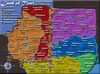
This is the original map.
Country's and continents still need to be added.

As you can see, the map is dutch.
The map originally came from a book, so that's why.
There are 3 empires: Unauwen, Dagonaut, Eviellan.

Any ideas for country's/continents???
Last edited by santon836 on Mon Feb 26, 2007 4:24 pm, edited 9 times in total.
User avatar
Private santon836
 
Posts: 126
Joined: Mon Nov 06, 2006 9:44 am

Postby Lone.prophet on Sat Jan 27, 2007 1:23 pm

Brief aan de koning :)
Image
Captain Lone.prophet
 
Posts: 1467
Joined: Thu Oct 12, 2006 4:37 pm
Location: Your basement Muahaha

Postby Coleman on Sat Jan 27, 2007 1:29 pm

I'd like to see this with more of the Conquer Club map look.
User avatar
Sergeant Coleman
 
Posts: 5402
Joined: Tue Jan 02, 2007 10:36 pm
Location: Midwest

Postby Nikita_2006 on Sat Jan 27, 2007 1:30 pm

Who has the copyrights of this map ?

If this is the writer are the publisher it is not easy to get permission to do something with it.

Please check it
Private Nikita_2006
 
Posts: 486
Joined: Thu Oct 19, 2006 8:35 am

Postby santon836 on Sat Jan 27, 2007 1:51 pm

Copyright ended in 1965 as I can see.
And, it's right, it's from the book "brief aan de koning" and "geheimen van het wilde woud".
The most important person in that book is Tiuri, so I called it "land of Tiuri".

I'm busy with making it more a CC map.

Any tips for continents/countrys??
Last edited by santon836 on Sun Jan 28, 2007 6:15 am, edited 1 time in total.
User avatar
Private santon836
 
Posts: 126
Joined: Mon Nov 06, 2006 9:44 am

Postby Nikita_2006 on Sat Jan 27, 2007 1:56 pm

OK than give it a try and show us a map so we can see how it looks
Private Nikita_2006
 
Posts: 486
Joined: Thu Oct 19, 2006 8:35 am

Postby santon836 on Sat Jan 27, 2007 2:15 pm

So far:

Image

Looks better as I expected.

Red: Empire-border
Blue: River
Mountains: Also border

But how to handle this number of rivers....
Is gonna be hard.
Last edited by santon836 on Sun Jan 28, 2007 6:15 am, edited 1 time in total.
User avatar
Private santon836
 
Posts: 126
Joined: Mon Nov 06, 2006 9:44 am

Postby Nikita_2006 on Sat Jan 27, 2007 2:19 pm

Problem, can you create anought countries on this map.

It looks a small map

The next link connects to the page of the writer, maybe you can contact her to get permission, and to let her know what you are up to.

http://www.kjoek.nl/tonkedragt.php
Private Nikita_2006
 
Posts: 486
Joined: Thu Oct 19, 2006 8:35 am

Postby santon836 on Sat Jan 27, 2007 2:32 pm

Well, in my opinion the copyright was expired..
Or it's the start date, that can also be.
I'll contact her, we'll see.
Underwhile I keep working.

All empire borders drawed, except Unauwen - Dagonaut:

Image

In case you didn't know:

Unauwen is the big left empire.
Dagonaut is the big right empire.
Eviellan is the southern empire.
Deltaland is a small empire, in the bottom right corner.
Last edited by santon836 on Sun Jan 28, 2007 6:15 am, edited 1 time in total.
User avatar
Private santon836
 
Posts: 126
Joined: Mon Nov 06, 2006 9:44 am

Postby onbekende on Sat Jan 27, 2007 3:25 pm

nice river names

perhaps think about making territories with those rivers
Emperor of the Benelux
Founder of the Commonwealth of Planets
Founder and CEO of JF
User avatar
Captain onbekende
 
Posts: 1530
Joined: Fri Apr 14, 2006 10:19 am
Location: Belgium

Postby Nikita_2006 on Sat Jan 27, 2007 3:37 pm

I did not read the book, but as Onbekende said the names sounds good.

Fill in some backgroundcolors if you can
Private Nikita_2006
 
Posts: 486
Joined: Thu Oct 19, 2006 8:35 am

Postby santon836 on Sat Jan 27, 2007 3:47 pm

Made some countries, will show them soon.
It's hard to do in paint, some1 knows better way??
But with the rivers it's oke to do.
Last edited by santon836 on Sun Jan 28, 2007 6:15 am, edited 1 time in total.
User avatar
Private santon836
 
Posts: 126
Joined: Mon Nov 06, 2006 9:44 am

Postby Lone.prophet on Sat Jan 27, 2007 4:54 pm

Photoshop is a better way
Image
Captain Lone.prophet
 
Posts: 1467
Joined: Thu Oct 12, 2006 4:37 pm
Location: Your basement Muahaha

Postby Nikita_2006 on Sat Jan 27, 2007 5:37 pm

Try to scan a better picture without the indistinctness in the middle of your map.

Or decide what part of your previous map becomes your CC map.
Private Nikita_2006
 
Posts: 486
Joined: Thu Oct 19, 2006 8:35 am

Postby Coleman on Sat Jan 27, 2007 6:33 pm

My advice is to use any graphic program that has layers and make all your drawing on top of the original image a separate layer and then get rid of the scan of the book completely and work with what you have drawn.
User avatar
Sergeant Coleman
 
Posts: 5402
Joined: Tue Jan 02, 2007 10:36 pm
Location: Midwest

Postby santon836 on Sun Jan 28, 2007 1:40 am

ok, will do so.

I found out photoshop works with layers, so I will use that.
Last edited by santon836 on Sun Jan 28, 2007 6:14 am, edited 1 time in total.
User avatar
Private santon836
 
Posts: 126
Joined: Mon Nov 06, 2006 9:44 am

Postby Wisse on Sun Jan 28, 2007 5:07 am

Coleman wrote:My advice is to use any graphic program that has layers and make all your drawing on top of the original image a separate layer and then get rid of the scan of the book completely and work with what you have drawn.

i did that with my china map :)
Image Image
User avatar
Sergeant Wisse
 
Posts: 4448
Joined: Fri Oct 13, 2006 2:59 pm
Location: The netherlands, gelderland, epe

Postby santon836 on Sun Jan 28, 2007 6:02 am

Image

As far as I am now.
With the new way of working I had to start over again, but it's better and faster to make now.
I'll soon get up to the countrys.
In some hours, there'll be an update again.
User avatar
Private santon836
 
Posts: 126
Joined: Mon Nov 06, 2006 9:44 am

Postby Lupo on Sun Jan 28, 2007 6:16 am

I think you should separate the 2 pages, so you could add the part of the map is missing between the 2 pages...

Maybe you could have a look at the original book to know how it was meant to look like
"Nature is a temple in which living pillars
Sometimes emit confused words;
Man crosses it through forests of symbols
That observe him with familiar glances."
User avatar
Sergeant 1st Class Lupo
 
Posts: 180
Joined: Fri Sep 15, 2006 1:33 pm

Postby santon836 on Sun Jan 28, 2007 7:55 am

The only things you can't see are mountains.
When this map is gone, you won't see there's anything missing.

New poll:

Which connection do you like best?
Image
1. The orange arrow
2. No arrow, just a line
3. The red arrow

Edit: Why can't I change my poll anymore??
User avatar
Private santon836
 
Posts: 126
Joined: Mon Nov 06, 2006 9:44 am

Postby santon836 on Sun Jan 28, 2007 10:33 am

Watch the work I've done:

Image

I made a raw sketch of the continents, in some empires. (Dagonaut still needs to be done)
I'm sorry it's such a slow-loading map.
Later versions will be zipped.
As you can see, Eviellan and Deltaland also have the countrys implemented.

What I still need to do:

- countrys in Unauwen
- continents and countrys in Dagonaut
- Legend, with bonuses

Opinions wanted!!
(advises also welcome)
User avatar
Private santon836
 
Posts: 126
Joined: Mon Nov 06, 2006 9:44 am

Postby bedplay on Mon Jan 29, 2007 12:08 pm

The map needs at least 6 continents I would say...

it's coming along nicely, next time, export the image and post the image as a jpeg, much smaller than png, and no1 can steal it! I especially like the mountains, great job!

oh and what about a black arrow?
"It is fatal to enter any war without the will to win it."
- General Douglas MacArthur
User avatar
Private 1st Class bedplay
 
Posts: 171
Joined: Fri Jan 19, 2007 2:00 pm

Postby coolst on Mon Jan 29, 2007 5:22 pm

my suggestion is that you put away the new colors, it don't make the map more beautifuler, because by the old map(without al those colors) looks more like an real map, so it seems me funnier when you play the game on this map, but the rocks and "grenzen" should i let how it is, that where good graphics.


what i mean is let the map in his old state, well maybe you have what on that advice maybe not. see ya santon
User avatar
Lieutenant coolst
 
Posts: 10
Joined: Thu Nov 09, 2006 12:00 pm

Postby santon836 on Tue Jan 30, 2007 2:12 am

Next update I'll try the black arrow.

And, coolst, I don't think I'm gonna remove the mountains like they are now.
I like them this way, and in the older version the pass-throughs are hard to see.
User avatar
Private santon836
 
Posts: 126
Joined: Mon Nov 06, 2006 9:44 am

Postby santon836 on Fri Feb 16, 2007 2:11 pm

Here is the next update.

After not working for a time, i decided to go back working.
I immedately did a lot of work.

Here is the last update:
Image

Still waiting for people to say something....
I need comments about everything:
- the legend style
- the pass-throughs in the mountains
- the font
- the rivers
- the continent colors
- the seas
- the title
- the bonuses
- the things I haven't done yet, but should do
- etc.

Plz comment!

(again sorry for the slow-loading image.... it's only 200 kb or something)
User avatar
Private santon836
 
Posts: 126
Joined: Mon Nov 06, 2006 9:44 am

Next

Return to Melting Pot: Map Ideas

Who is online

Users browsing this forum: No registered users