Conquer Club

Canary Islands -- New Update (still p. 1)

Have an idea for a map? Discuss ideas and concepts here.

Moderator: Cartographers

Forum rules
Please read the Community Guidelines before posting.

Canary Islands -- New Update (still p. 1)

Postby santon836 on Wed May 13, 2009 1:10 pm

Countries: 44, but subject to change.
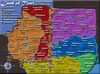
Continents: 7, which are: Tenerife - 11 countries, 4 borders. Lanzarote - 9 countries, 2 borders. Gran Canaria - 7 countries, 2 borders. Fuerteventura - 7 countries, 2 borders. La Palma - 5 countries, 1 border. La Gomera - 3 countries, 1 border. El Hierro - 3 countries, 1 border.
Airports: 5, in Abona, Puerto de la Cruz (Tenerife), Arrecife (Lanzarote), Las Palmas (Gran Canaria), Santa Cruz (La Palma). These all connect. Bonus for holding them: 2 for 3, 3 for 4, 4 for 5.

Click image to enlarge.
image

Other drafts:
Draft 1.0: http://img10.imageshack.us/img10/4268/canaryislands2copyd.jpg

--- Original Post ---
show
Last edited by santon836 on Thu May 21, 2009 4:41 am, edited 4 times in total.
User avatar
Private santon836
 
Posts: 126
Joined: Mon Nov 06, 2006 9:44 am

Re: Canary Islands

Postby mattosaurus on Wed May 13, 2009 1:31 pm

I would make the lines connect across the sea. The bonuses look right, graphics are ok, but you might want to condense a bit and make the land more prominent. I personally like larger maps, so maybe more territories on the islands. This will be a highly conservative map, making it relatively easy to hold borders with the islands. You might want to increase attackability amongst the territories. Maybe make a capital or cities for territories with extra bonuses.
Check out my map in the making: Testosterone VS Estrogen
http://www.conquerclub.com/forum/viewtopic.php?f=241&t=85196
User avatar
Sergeant 1st Class mattosaurus
 
Posts: 73
Joined: Thu Feb 26, 2009 1:38 pm
Location: North Carolina

Re: Canary Islands

Postby captainwalrus on Wed May 13, 2009 2:07 pm

Could you put the english on the map mabey smaller underneath the text on there now, since I don't think people will want to go to the forum to see how it is played. I like the graphics, though!
User avatar
Private 1st Class captainwalrus
 
Posts: 1018
Joined: Sun Nov 11, 2007 3:19 pm
Location: Finnmark

Re: Canary Islands

Postby thenobodies80 on Wed May 13, 2009 4:11 pm

Nice first draft ;)
And some quick suggestions:

  • Your map is too big, there are many unused/unnecessary space.

    1. SMALL MAP: WIDTH up to 630 px; HEIGHT 600 px
    2. LARGE MAP: WIDTH up to 840 px ; HEIGHT 800 px.
    3. SIZE DIFFERENTIAL: A large map must be noticably larger than their small map; 9% larger is required but 33.3% (1/3rd) is recommended.
    4. NOTE: Mapmakers are encouraged to make their large maps smaller than the maximum size limits when possible to eliminate scrolling to attack/read the sidebar info.


    Read here : http://www.conquerclub.com/forum/viewtopic.php?f=10&t=40463#p1047003


  • Borders disappear on the darker zones of tenerife, Gran Canaria and LaGomera
  • Translate the map to english

Good Starting point =D>

TNBDS
User avatar
Sergeant 1st Class thenobodies80
 
Posts: 5400
Joined: Wed Sep 05, 2007 4:30 am
Location: Milan

Re: Canary Islands

Postby santon836 on Thu May 14, 2009 1:50 am

santon836 wrote:The map is still in Dutch, because I didn't mind translating it yet, but if enough people like the map I will make another draft which will be in English.


The translation will come soon. I will make another draft and that draft will be English.

I also had a few reasons not to make the sea routes connect: a. because they will intersect b. because they will make turns and that won't look as good c. because it would be much harder to make them having turns and d. in my opinion this is as clear as when they would connect. If most of you want it, I can still do it, of course.

As for the map being too big: for now it is just me. I should have resized it. As I wanted to print it I made Photoshop give it the size of 60 by 40 cm, which turns out to be way too large for CC. I will keep working on this size, but I will resize the coming drafts when I upload them.

I don't know if I should move the islands closer together: they do are islands. I have already moved them much closer together than they are in real. If I move them closer together I'm afraid the sea would look more like a river. Or is that just me? As a last point I must add that they are not puzzle pieces: they do not fit in. And I really want to preserve the order in which they are now: it is similar to reality. I wouldn't want to move El Hierro all the way to the right, for example.

And yes, you are right about the borders disappearing. I will change that, however I don't know how yet. Making them darker won't work, making them lighter will make them hard to see in other places. I could change the color in the darker areas of the map, but that would require some sort of a fade, I guess?]

Capitals sound good. Would that be similar to holding all airports? Should I maybe add a bonus for holding 3 or even 4 airports? That would be an idea.

As for the attackability: the sea routes I have now are the routes 'in real'. The only difference is Morro Jable having 2 sea routes (to S. Cruz (tenerife) and Las Palmas) in real and none in my map. Should I still add those? Also, in real all islands have an airport, but if I add them everywhere they would nihilate the point of the sea routes.
User avatar
Private santon836
 
Posts: 126
Joined: Mon Nov 06, 2006 9:44 am

Re: Canary Islands

Postby Hatchman on Thu May 14, 2009 5:07 am

Excellent idea. Looks fantastic. I say go for it!

I would make the airplane icons less like commuter jets and more like propeller planes (more appropriate to the tropical theme). And hey, why not mark the sea routes with sailboats or somethin equally pretty? 8-)
User avatar
Major Hatchman
 
Posts: 792
Joined: Sat Jan 13, 2007 6:05 am
Location: The charming village of Emery

Re: Canary Islands -- Update coming soon

Postby santon836 on Mon May 18, 2009 1:14 pm

So, the update is coming soon. Don't know when exactly, but perhaps tomorrow or in two days. If anything else comes up in your mind: please share! Now is your time!

(Don't bother about the 29129048 other possible times ahead, trust me, this is the best of them all)
User avatar
Private santon836
 
Posts: 126
Joined: Mon Nov 06, 2006 9:44 am

Re: Canary Islands

Postby thenobodies80 on Mon May 18, 2009 2:23 pm

santon836 wrote:I also had a few reasons not to make the sea routes connect: a. because they will intersect b. because they will make turns and that won't look as good c. because it would be much harder to make them having turns and d. in my opinion this is as clear as when they would connect. If most of you want it, I can still do it, of course.


I'm agree with you, routes are ugly if connected, i did a test ;)
Symbols? :-k (it's only an idea)

santon836 wrote:I don't know if I should move the islands closer together: they do are islands. I have already moved them much closer together than they are in real. If I move them closer together I'm afraid the sea would look more like a river. Or is that just me? As a last point I must add that they are not puzzle pieces: they do not fit in. And I really want to preserve the order in which they are now: it is similar to reality. I wouldn't want to move El Hierro all the way to the right, for example.


First cut the map. You have 45 px of unused space on the left, 29px on the right.
Then you have some unused space in the upper part (about 24px with a smaller title) and in the lower part (45px with a different/smaller legend).
Finally resize your map, but in this way you'll have bigger islands. I did a quick test, the map was nice, and no islands moved :)

santon836 wrote:And yes, you are right about the borders disappearing. I will change that, however I don't know how yet. Making them darker won't work, making them lighter will make them hard to see in other places. I could change the color in the darker areas of the map, but that would require some sort of a fade, I guess?


Try to change the background, now borders desappear only where there are some palms of the background; Or apply palms only on water? For ground try to use a different texture.

Waiting your update.... ;)

thenobodies80
User avatar
Sergeant 1st Class thenobodies80
 
Posts: 5400
Joined: Wed Sep 05, 2007 4:30 am
Location: Milan

Re: Canary Islands -- Update coming soon

Postby santon836 on Wed May 20, 2009 2:05 pm

So, here is the update. I've done a few things:
  • Cropped the image
  • Moved La Palma and El Hierro a little bit to the right (which was absolutely terrible, because just El Hierro consists of 9 layers: 2 masks, the land, the borders, 4 texts and the sea routes)
  • Changed the legend
  • Completely restyled the borders to brown
  • Changed the airplanes
  • Translated the map
  • Got rid of the ocean signs
  • Toyed a little bit with the sea route signs, because they are not as legible as I would like them. Any suggestions for this?
Click image to enlarge.
image

I've also outlined Lanzarote and La Gomera, just to give an idea of what it would look like. I think it makes the islands stand out more. Question is if that's what we want.

Edit: Small question: how do I get the original part in the first post in a hide and show-bow?
User avatar
Private santon836
 
Posts: 126
Joined: Mon Nov 06, 2006 9:44 am

Re: Canary Islands -- New Update (still p. 1)

Postby Danyael on Wed May 20, 2009 4:03 pm

looks really nicce
for the hide and show [ spoiler][ /spoiler] with out the spaces if thats what you mean
User avatar
Corporal 1st Class Danyael
 
Posts: 352
Joined: Fri Jul 04, 2008 4:26 pm
Location: Winnipeg, Manitoba

Re: Canary Islands -- New Update (still p. 1)

Postby laughingcavalier on Tue Jun 02, 2009 7:00 pm

Nice.
The palm trees in the background ae just a distraction!
Still need to make the ferry routes clearer. Maybe a circle and/or line the same colour as the island the ferry is going to??
Can you rename one of the Santa Cruz's - or is that just too wrong geographically?
Major laughingcavalier
 
Posts: 1117
Joined: Mon Mar 12, 2007 4:31 pm

Re: Canary Islands -- New Update (still p. 1)

Postby santon836 on Wed Jun 03, 2009 1:19 am

The coloring would be an idea.. Let me see if that works out well. I will try this out in the next draft.
The problem with the Santa Cruz's is indeed that both the capital of La Palma and Tenerife are called Santa Cruz. I think renaming it would be rude, especially because it is the capital (or at least the main city).

Come on people, I really need more suggestions before I make another draft! You've had since the 20th of May to respond!
User avatar
Private santon836
 
Posts: 126
Joined: Mon Nov 06, 2006 9:44 am

Re: Canary Islands -- New Update (still p. 1)

Postby Echospree on Wed Jun 03, 2009 9:00 am

If renaming one of the Santa Cruz's is out of the question, you'll probably have to set each one as Santa Cruz [T] and Santa Cruz [L] to differentiate. How do locals in the area deal with the fact the locations have the same name? That piece of information could help find a solution.

I really dislike how the sea routes are connected, though, it's somewhat difficult to understand how they flow. Maybe change the connections such that they don't intersect at all, so that we can have unbroken lines? Possibly just create port icons, and each port can attack each other.

If that's too fluid, make two/three different port icons, and only similar port icons can attack each other.
User avatar
Major Echospree
 
Posts: 169
Joined: Wed Feb 11, 2009 3:03 pm

Re: Canary Islands -- New Update (still p. 1)

Postby thetheo on Wed Jun 03, 2009 9:41 am

what are the dotted lines? If they are not sea borders, suggest having sea lines that connect island to island.
Private 1st Class thetheo
 
Posts: 46
Joined: Thu May 14, 2009 2:37 am

Re: Canary Islands -- New Update (still p. 1)

Postby santon836 on Wed Jun 03, 2009 12:00 pm

Well, the cities' names are in fact 'Santa Cruz de Tenerife' and 'Santa Cruz de La Palma'. As most locals won't have size problems, they will use these names. It won't be a solution for our problem, though. Adding colors or [L] and [T] in brackets could help.

As for the port icons: having one would be, as you say, too fluid. Wouldn't having different completely isolate some zones on the map? If, for example, Lanzarote and Fuerteventura have unique icons, wouldn't they be isolated? *hits himself* We're lucky we have the airports :P

I also thought about making the lines dotted instead of having them consist of lines, but that wouldn't solve the intersection problem, would it? The only intersection I could find, by the way, is the intersection between the lines from Las Palmas and the line Playa Blanca - La Oliva. The second line is quite crucial, as it adds one border to Lanzarote.
User avatar
Private santon836
 
Posts: 126
Joined: Mon Nov 06, 2006 9:44 am

Re: Canary Islands -- New Update (still p. 1)

Postby squishyg on Wed Jun 03, 2009 2:15 pm

It's got a lot of promise. The blue lettering on the blue ocean is really hard to read though.
User avatar
Captain squishyg
 
Posts: 2651
Joined: Sun Jan 04, 2009 11:05 pm

Re: Canary Islands -- New Update (still p. 1)

Postby Hatchman on Wed Jun 03, 2009 6:18 pm

Boats! I wanna see boats! :D
User avatar
Major Hatchman
 
Posts: 792
Joined: Sat Jan 13, 2007 6:05 am
Location: The charming village of Emery

Re: Canary Islands -- New Update (still p. 1)

Postby thenobodies80 on Thu Jun 04, 2009 2:02 pm

The brown borders are nice, but aren't so clear on Fuerteventura.
I think you have to change the texture on islands...as suggested previous.
You can think to develope a more realistic sea removing the palm background. Then work on sea to make it less flat.

Text on sea routes is too small and difficult to understand.
You can think to use a symbol, you used a plane for airport....why not using boat for ports? ;)

Santa Cruz is a problem and you can't change the names because they are 2 main cities. So using the "real long" names is probably the better choice....Is it so ugly on the map? #-o

I will focus on the gameplay on my next passage here ;)

You did some good improvements. :)
Nice work =D>

thenobodies80
User avatar
Sergeant 1st Class thenobodies80
 
Posts: 5400
Joined: Wed Sep 05, 2007 4:30 am
Location: Milan

Re: Canary Islands -- New Update (still p. 1)

Postby Echospree on Thu Jun 04, 2009 2:44 pm

I don't mean unique icons for each island.

I was thinking more along the lines of having 'red' ports, 'blue' ports and maybe 'green' ports. Each port of the same colour can only attack each other, and you'd have two or three of each colour port.

I do like a long dotted line idea, too, it wouldn't be difficult to see which port connects to what.
User avatar
Major Echospree
 
Posts: 169
Joined: Wed Feb 11, 2009 3:03 pm

Re: Canary Islands -- New Update (still p. 1)

Postby santon836 on Fri Jun 05, 2009 1:22 am

Next update will contain:
  • (White) Boats! :P (I think they will resemble the ports)
  • A non-palm sea
  • Toned down textures on the islands, to see if it helps
  • In some way or another, clearer sea routes
  • Long Santa Cruz names

What about having a searoute schedule? It could look pretty neat if I put some time into it and the islands could maybe be moved a bit closer. Next update will have clearer searoutes, though: if that solves the problem, no need for a schedule.

Last note: would some of you please take a look at the outline of La Gomera and Lanzarote? I just had a try at doing it, but I don't know if it looks better or worse. The other islands are not outlined, so you can see the difference. If it is hard to judge, I will make two versions next time, one outlined and one not.

Thanks for all comments :)

Edit: was looking for a nice sailboat.. Found this. Thought it was pretty funny. The boat itself is unfortunately too detailed. There are some good other that I can use, however.
Image
User avatar
Private santon836
 
Posts: 126
Joined: Mon Nov 06, 2006 9:44 am

Re: Canary Islands -- New Update (still p. 1)

Postby Hatchman on Fri Jun 05, 2009 4:48 am

That is a pretty nice boat =D>
User avatar
Major Hatchman
 
Posts: 792
Joined: Sat Jan 13, 2007 6:05 am
Location: The charming village of Emery

Re: Canary Islands -- New Update (still p. 1)

Postby Echospree on Fri Jun 05, 2009 9:19 am

I prefer the non-outline version, actually. Makes them looks more like islands, rather than floating fortresses.
User avatar
Major Echospree
 
Posts: 169
Joined: Wed Feb 11, 2009 3:03 pm

Re: Canary Islands -- New Update (still p. 1)

Postby squishyg on Fri Jun 05, 2009 11:09 pm

Echospree wrote:I prefer the non-outline version, actually. Makes them looks more like islands, rather than floating fortresses.


I second that. The non-outlined version was really pretty and looked like an actual map.
User avatar
Captain squishyg
 
Posts: 2651
Joined: Sun Jan 04, 2009 11:05 pm

Re: Canary Islands -- New Update (still p. 1)

Postby thenobodies80 on Sat Jun 20, 2009 5:21 pm

santon836 wrote:Last note: would some of you please take a look at the outline of La Gomera and Lanzarote? I just had a try at doing it, but I don't know if it looks better or worse. The other islands are not outlined, so you can see the difference. If it is hard to judge, I will make two versions next time, one outlined and one not.


mmm :-k
I like the not outlined version.Marked borders seem unnecessary on the coast
I'll leave more comments on the next update ;)
User avatar
Sergeant 1st Class thenobodies80
 
Posts: 5400
Joined: Wed Sep 05, 2007 4:30 am
Location: Milan

Re: Canary Islands -- New Update (still p. 1)

Postby santon836 on Thu Jun 25, 2009 1:42 pm

I am currently working on the next draft. I have already changed sea routes into anchors (sorry for the boats, maybe the boats come back later on) in several colors. Some terits (Playas de Tenerife, both Santa Cruz's and Las Palmas) have two anchors in different colors to make the sea routes connect. The connections still remain the same.
I also have changed the names of the SC's and moved some borders and some text to make space for army circles/numbers later on.

I still have to change the legend to make this clear, remove the sea texture, tone the land texture down and remove the outline.
User avatar
Private santon836
 
Posts: 126
Joined: Mon Nov 06, 2006 9:44 am

Next

Return to Melting Pot: Map Ideas

Who is online

Users browsing this forum: No registered users