Plain United States of America simple
Map
http://images.google.com/imgres?imgurl= ... s%3Disch:1
Alaska connects to Hawaii and Washington
Hawaii connects to Alaska and Arizona
Washington D.C. is a territory
YOUR FAVORITE MAP-MAKER,
tonbomorphew
simply USA
Moderator: Cartographers
77 posts
• Page 1 of 4 • 1, 2, 3, 4
simply USA
![]() by tonbomorphew on Sat May 01, 2010 11:13 am
by tonbomorphew on Sat May 01, 2010 11:13 am
-
 tonbomorphew
- Posts: 100
- Joined: Sun Jan 31, 2010 12:49 pm


Re: simply USA
![]() by Evil DIMwit on Sat May 01, 2010 12:49 pm
by Evil DIMwit on Sat May 01, 2010 12:49 pm
In fact, we've already got a simple USA map. It's called "USA."


-

Evil DIMwit
- Posts: 1616
- Joined: Thu Mar 22, 2007 1:47 pm
- Location: Philadelphia, NJ


Re: simply USA
![]() by shakeycat on Sat May 01, 2010 1:51 pm
by shakeycat on Sat May 01, 2010 1:51 pm
If there's any USA maps left to do, it would be Hawaii and Alaska, since all others focus on the continental USA, even the USA map pack. Surely there have been attempts before, though?
Current Map Project: Tokyo
-

shakeycat
- Posts: 390
- Joined: Sun Mar 11, 2007 5:13 am
- Location: Vancouver


Re: simply USA
![]() by ManBungalow on Sat May 01, 2010 1:56 pm
by ManBungalow on Sat May 01, 2010 1:56 pm
As Natty says, there are already plenty of USA maps on the site.
Off the top of my head, there's the USA map pack (South-West, Rockies and several others), the standard one Natty linked above, Route 66, USApocalypse, Rail USA, Great Lakes, US Senate and so on..
Keep an eye out for some original ideas and post them in here.
Off the top of my head, there's the USA map pack (South-West, Rockies and several others), the standard one Natty linked above, Route 66, USApocalypse, Rail USA, Great Lakes, US Senate and so on..
Keep an eye out for some original ideas and post them in here.

-
ManBungalow
- Posts: 3431
- Joined: Sun Jan 13, 2008 7:02 am
- Location: On a giant rock orbiting a star somewhere


Re: simply USA
![]() by MarshalNey on Sat May 01, 2010 3:37 pm
by MarshalNey on Sat May 01, 2010 3:37 pm
I do have to say that the USA map bugs me. A lot of it goes well beyond mere "gameplay liberties," it's bewilderingly apocryphal.
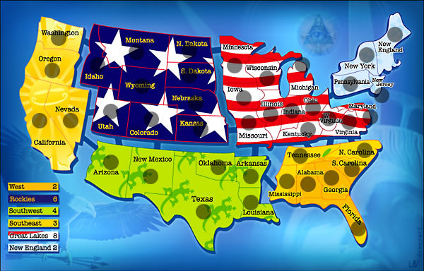
I hate the separation of regions- what is really wrong with using actual terrain for impassibles? You don't have to include every mountain range, but what's wrong with including the Rocky Mountains? With the Rockies, the Mississippi and Missouri Rivers, the Appalachian Mountains and the Sierra Nevada-Cascades Ranges, you've got a pretty decent broad overview of the topogrophy and plenty of impassibles.
Even more, however, I hate the fictional regions themselves. I've never heard of the "Rockies" as a cultural region (where did they get that from, the time zone? They'd have been better off using the Appalachians) nor have I ever heard anyone refer to Missouri, Iowa, Kentucky, W. Virginia, Viginia or Maryland as a "Great Lakes" state... since they're hundreds upon hundreds of miles away from the Great Lakes. The Midwest is scandalously divided in half and lumped into the "Great Lakes" designation, which I also have never heard of as a region but I'm willing to forgive far more than "Rockies". The Deep South is arbitrarily split between "Southwest" and "Southeast" and the "West" is almost a misnomer since it's pretty much just West Coast. There are, of course, many different ways to classify the same place ("Great Plains" as opposed to West or Midwest, for example) but there's just no consistency or even justification in some cases for the designations given.
Then there are places left completely out. As shakeycat said, Alaska and Hawaii aren't even included, nor of course are any of the reservations, territories, "commonwealths" or protectorates that produce natural-born US citizens. And to add final insult to injury, New England- the only region that is almost properly named- has amalgamated some of the small states and left others out (Maryland & DC in particular!).
I mean for goodness' sake, there's 50 stars on the flag, everyone knows what that stands for. How hard is it to have at least 50 freakin' territories on the map? It's not like we're talking about Old World countries where some provinces changed hands and borders dozens of times over the centuries and such distinctions get blurred between the traditional/cultural and the modern legal definition. American states pretty much fixed their borders before being granted statehood- no ambiguity. And don't tell me that state designations are meaningless in America (I will grant that jingoistic nationalism has reduced their importance) unless you want to get into a serious debate about history, the Constitution, geography and culture.
I don't expect a CC map to serve as a dual atlas and gameboard. But this map goes well beyond mere artistic liberties for playability.
I know that this rant is a bit off-topic, and probably a bit unfair. It really belongs as a revamp discussion perhaps in the USA map thread. But I'm saying it also because I think the current USA map would need way more than a revamp to address my issues with it. CC is overloaded with US maps, I know, but it shocks me how many of them exist and yet how few of them are any good as guides to the US. They play just fine, good balance- but as for accuracy, they'd be better off as fantasy maps. The only relatively accurate US map that I can think of is 13 Colonies... and Civil War (maybe a few others).
EDIT: I'm not really bucking to change the USA maps- I mean it's an entire map pack and players enjoy them, so what's the harm?... and I like Widowmakers' stuff for the most part. I'm just saying that there certainly is a different way of approaching the US that I haven't yet seen in any of the USA maps...
-

MarshalNey
- Posts: 781
- Joined: Mon Sep 28, 2009 9:02 pm
- Location: St. Louis, MO


Re: simply USA
![]() by tonbomorphew on Sat May 01, 2010 4:19 pm
by tonbomorphew on Sat May 01, 2010 4:19 pm
look ok there missing VII territories and half the time like ok to co they should be
able to attack or kansas to ok
http://maps.conquerclub.com/USA.L.jpg
able to attack or kansas to ok
http://maps.conquerclub.com/USA.L.jpg
-
tonbomorphew
- Posts: 100
- Joined: Sun Jan 31, 2010 12:49 pm
Re: simply USA
![]() by Evil DIMwit on Sat May 01, 2010 5:42 pm
by Evil DIMwit on Sat May 01, 2010 5:42 pm
tonbomorphew wrote:look ok there missing VII territories and half the time like ok to co they should be
able to attack or kansas to ok
http://maps.conquerclub.com/USA.L.jpg
-
Evil DIMwit
- Posts: 1616
- Joined: Thu Mar 22, 2007 1:47 pm
- Location: Philadelphia, NJ
Re: simply USA
![]() by army of nobunaga on Sat May 01, 2010 11:46 pm
by army of nobunaga on Sat May 01, 2010 11:46 pm
guys, I have to agree... US and Europe seems to be THE map makers choice of creation.
Why not a lewis and clark map. A lousianna purchase map. how about a south central LA map... lot of ideas out ehre that noone even seems to think about that would be fruitful, fun, and epic.
I dont think a simple USA map will map it through all the stages.
And yes I agree.. they concept of our current USA map has some holes regionally... But I have to admit the bonus structures and regions play beautifully.
Maps Maps Maps!
Take part in this survey and possibly win an upgrade -->
https://docs.google.com/spreadsheet/embeddedform?formkey=dGg4a0VxUzJLb1NGNUFwZHBuOHRFZnc6MQ
Take part in this survey and possibly win an upgrade -->
https://docs.google.com/spreadsheet/embeddedform?formkey=dGg4a0VxUzJLb1NGNUFwZHBuOHRFZnc6MQ
-

army of nobunaga
- Posts: 1989
- Joined: Sat Oct 13, 2007 10:06 pm
- Location: www.facebook.com/armyofnobu and Houston.


Re: simply USA
![]() by tonbomorphew on Sun May 02, 2010 11:30 am
by tonbomorphew on Sun May 02, 2010 11:30 am
.....
Last edited by tonbomorphew on Tue Nov 09, 2021 1:34 am, edited 1 time in total.
-
tonbomorphew
- Posts: 100
- Joined: Sun Jan 31, 2010 12:49 pm
Re: simply USA
![]() by The Bison King on Mon May 17, 2010 2:43 pm
by The Bison King on Mon May 17, 2010 2:43 pm
You know I'm still behind this idea. I know there are a lot of USA maps all ready, but that's only because it rules too much to conquer. Just like Europe.
50 states = 50 territories No Bullshit I'm behind it.
50 states = 50 territories No Bullshit I'm behind it.

-

The Bison King
- Posts: 1957
- Joined: Thu Aug 27, 2009 5:06 pm
- Location: the Mid-Westeros


Re: simply USA
![]() by FlyingSquirrel on Tue May 18, 2010 9:00 pm
by FlyingSquirrel on Tue May 18, 2010 9:00 pm
I'm working on something similar, but with the US Election in mind. If you'd like to use my map image as a starting point for your project, be my guest.
http://i702.photobucket.com/albums/ww25 ... _Setup.png
http://i702.photobucket.com/albums/ww25 ... _Setup.png
-
FlyingSquirrel
- Posts: 49
- Joined: Tue Apr 27, 2010 12:28 am
Re: simply USA
![]() by Industrial Helix on Tue May 18, 2010 9:39 pm
by Industrial Helix on Tue May 18, 2010 9:39 pm
I was kind of thinking about this as a sort of successor to 13 Colonies... basically, 50 states with a build your own bonus by holding states.
Sketchblog [Update 07/25/11]: http://indyhelixsketch.blogspot.com/
Living in Japan [Update 07/17/11]: http://mirrorcountryih.blogspot.com/
Russian Revolution map for ConquerClub [07/20/11]: viewtopic.php?f=241&t=116575
Living in Japan [Update 07/17/11]: http://mirrorcountryih.blogspot.com/
Russian Revolution map for ConquerClub [07/20/11]: viewtopic.php?f=241&t=116575
-

Industrial Helix
- Posts: 3462
- Joined: Mon Jul 14, 2008 6:49 pm
- Location: Ohio


Re: simply USA
![]() by Evil DIMwit on Tue May 18, 2010 10:09 pm
by Evil DIMwit on Tue May 18, 2010 10:09 pm
Industrial Helix wrote:I was kind of thinking about this as a sort of successor to 13 Colonies... basically, 50 states with a build your own bonus by holding states.
We'd be looking at about 150-ish territories for that? Possibly more?
-
Evil DIMwit
- Posts: 1616
- Joined: Thu Mar 22, 2007 1:47 pm
- Location: Philadelphia, NJ
Re: simply USA
![]() by army of nobunaga on Tue May 18, 2010 10:26 pm
by army of nobunaga on Tue May 18, 2010 10:26 pm
Industrial Helix wrote:I was kind of thinking about this as a sort of successor to 13 Colonies... basically, 50 states with a build your own bonus by holding states.
It would work... and I wouldnt like hate it... Just not super original.
There would have to be a lot of thought into the bonus of each state... like Tennessee borders like 6 states? and Hawaii and alaska would have to be figured out. There are a lot of really small states that would be tough to but 3 digit armys in.
I cant lie though.. If someone made it, Id play it.
I would like to see like true barriers if this is going to be a true map. For instance, the rocky mountains in real life have many many many cross points... I hate the idea of just having the chain as an impassable.
I dunno. gl in it. Its an Idea worth pursuing in my mind. Id rather see a nepal map or a K2 (the mountain) or a source of the nile map... there are like 1000 ideas I have that are unique and cool that would be more fun, but this one would have its place.
Maps Maps Maps!
Take part in this survey and possibly win an upgrade -->
https://docs.google.com/spreadsheet/embeddedform?formkey=dGg4a0VxUzJLb1NGNUFwZHBuOHRFZnc6MQ
Take part in this survey and possibly win an upgrade -->
https://docs.google.com/spreadsheet/embeddedform?formkey=dGg4a0VxUzJLb1NGNUFwZHBuOHRFZnc6MQ
-
army of nobunaga
- Posts: 1989
- Joined: Sat Oct 13, 2007 10:06 pm
- Location: www.facebook.com/armyofnobu and Houston.
Re: simply USA
![]() by Industrial Helix on Wed May 19, 2010 7:34 am
by Industrial Helix on Wed May 19, 2010 7:34 am
Evil DIMwit wrote:Industrial Helix wrote:I was kind of thinking about this as a sort of successor to 13 Colonies... basically, 50 states with a build your own bonus by holding states.
We'd be looking at about 150-ish territories for that? Possibly more?
Yeah... it would something like that. Unless you did 50 territories... the game engine should control equal deployment, right? Someone might have a first strike capability but the bonus system could be rigged to diminish its power.
Sketchblog [Update 07/25/11]: http://indyhelixsketch.blogspot.com/
Living in Japan [Update 07/17/11]: http://mirrorcountryih.blogspot.com/
Russian Revolution map for ConquerClub [07/20/11]: viewtopic.php?f=241&t=116575
Living in Japan [Update 07/17/11]: http://mirrorcountryih.blogspot.com/
Russian Revolution map for ConquerClub [07/20/11]: viewtopic.php?f=241&t=116575
-
Industrial Helix
- Posts: 3462
- Joined: Mon Jul 14, 2008 6:49 pm
- Location: Ohio
Re: simply USA
![]() by The Bison King on Wed May 19, 2010 4:15 pm
by The Bison King on Wed May 19, 2010 4:15 pm
I was kind of thinking about this as a sort of successor to 13 Colonies... basically, 50 states with a build your own bonus by holding states.
I'm listening... can you describe how the "build your own bonus" system works?
-
The Bison King
- Posts: 1957
- Joined: Thu Aug 27, 2009 5:06 pm
- Location: the Mid-Westeros
Re: simply USA
![]() by Industrial Helix on Wed May 19, 2010 9:57 pm
by Industrial Helix on Wed May 19, 2010 9:57 pm
The Bison King wrote:I was kind of thinking about this as a sort of successor to 13 Colonies... basically, 50 states with a build your own bonus by holding states.
I'm listening... can you describe how the "build your own bonus" system works?
Take a look at 13 Colonies... Basically each colony is its own bonus worth 0. Then the superbonus brackets in the XML are used to create a superbonus out of the 13 individual bonuses. In the end it looks something like this:
Hold any 2 Colonies (regular bonuses) for a bonus of 3 and in the XML you list out all thirteen regular bonuses. Any two of the 13 can give a bonus of 3. Sometimes its something like 2 single territory bonuses, like Connecticut and Rhode Island, or a territory heavy bonus like Virginia and New York. Play a few games on the map and you'll get it.
Sketchblog [Update 07/25/11]: http://indyhelixsketch.blogspot.com/
Living in Japan [Update 07/17/11]: http://mirrorcountryih.blogspot.com/
Russian Revolution map for ConquerClub [07/20/11]: viewtopic.php?f=241&t=116575
Living in Japan [Update 07/17/11]: http://mirrorcountryih.blogspot.com/
Russian Revolution map for ConquerClub [07/20/11]: viewtopic.php?f=241&t=116575
-
Industrial Helix
- Posts: 3462
- Joined: Mon Jul 14, 2008 6:49 pm
- Location: Ohio
Re: simply USA
![]() by Peter Gibbons on Thu May 20, 2010 11:42 pm
by Peter Gibbons on Thu May 20, 2010 11:42 pm
Alaska... viewtopic.php?f=242&t=80565&start=0&hilit=Alaskashakeycat wrote:If there's any USA maps left to do, it would be Hawaii and Alaska, since all others focus on the continental USA, even the USA map pack. Surely there have been attempts before, though?
-

Peter Gibbons
- Posts: 1077
- Joined: Wed Sep 10, 2008 9:21 am
- Location: Washington, DC


Re: simply USA
![]() by Peter Gibbons on Fri May 21, 2010 12:05 am
by Peter Gibbons on Fri May 21, 2010 12:05 am
Without being too long-winded, I've always felt that the site could use one really strong normal United States geography map. The "USA" map plays well, and I don't want to see it replaced/revamped because it fits with the map pack, but I still think there's room for something more. Europe has "Europe," "Europa," and "Europe 1914" for starters.
With the advent of the Hive map, I was thinking it might be possible to make a massive United States map. Here's what I had in mind.
1) All 50 states plus the District of Columbia are represented.
2) Each states is represented with 1-5 territories. Examples of what I'd have in mind are:
Rhode Island - 1 territory - +1 autodeploy
Massachusetts - 2 territories (Mass Bay and Berkshires) - +1
Tennessee - 3 territories (East, Middle & West) - +2
Florida - 4 territories (Panhandle, Tampa Bay, Everglades, Miami) - +3
Texas - 5 territories (Northern, Bay Area, Death Valley, Southern, Tahoe) - +4
These states would be designed partially on size and partially on population... so places like Montana and Nevada might only be +2s, despite their size. In this sort of system, you'd probably end up with a map of 140 territories or so.
3) There would be opportunities for plenty of natural impassables.
4) There would be 10 airports that all connect. Anchorage and Honolulu are obvious, so that they connect to the lower 48. The other 8 could be Los Angeles, Denver, Minneapolis, Houston, Miami, Detroit, New York, Boston (or whatever named territories they reside in).
5) There would be a sea route from Seattle to Juneau. There could be additional sea routes in the Gulf so that Florida wasn't a bottleneck.
-
Peter Gibbons
- Posts: 1077
- Joined: Wed Sep 10, 2008 9:21 am
- Location: Washington, DC
Re: simply USA
![]() by Evil DIMwit on Fri May 21, 2010 2:07 am
by Evil DIMwit on Fri May 21, 2010 2:07 am
Are you planning to do the Northeast in an inset or something? Because otherwise I don't think there'll be room for more than one territory in Massachusetts.
-
Evil DIMwit
- Posts: 1616
- Joined: Thu Mar 22, 2007 1:47 pm
- Location: Philadelphia, NJ
Re: simply USA
![]() by Industrial Helix on Fri May 21, 2010 8:33 am
by Industrial Helix on Fri May 21, 2010 8:33 am
A new England inset would be the way to go I think. Possibly one for DC/Maryland and Delaware as well.
There ought to be little gameplay quirks as well. For example, states that border the great lakes can use the lakes to attack each other. Ohio attacks Wisconsin for example.
I also think that rivers are an unused geographical thing. Why can't you attack downstream? I'd like to see the Mississippi have some sort of attribute like that.
If you're doing airplanes... why not have regional airports connect to the major airports which connect to each other? For example, Cleveland, Philadelphia, Boston airports all connect to New York which connects to D.C., LA, Atlanta, ect.
Sketchblog [Update 07/25/11]: http://indyhelixsketch.blogspot.com/
Living in Japan [Update 07/17/11]: http://mirrorcountryih.blogspot.com/
Russian Revolution map for ConquerClub [07/20/11]: viewtopic.php?f=241&t=116575
Living in Japan [Update 07/17/11]: http://mirrorcountryih.blogspot.com/
Russian Revolution map for ConquerClub [07/20/11]: viewtopic.php?f=241&t=116575
-
Industrial Helix
- Posts: 3462
- Joined: Mon Jul 14, 2008 6:49 pm
- Location: Ohio
Re: simply USA
![]() by Evil DIMwit on Fri May 21, 2010 8:52 am
by Evil DIMwit on Fri May 21, 2010 8:52 am
This all sounds like it can get very complicated, very quickly (which is, incidentally, the opposite of the thread title). Are you sure it can all fit?
-
Evil DIMwit
- Posts: 1616
- Joined: Thu Mar 22, 2007 1:47 pm
- Location: Philadelphia, NJ
77 posts
• Page 1 of 4 • 1, 2, 3, 4
Return to Melting Pot: Map Ideas
Who is online
Users browsing this forum: No registered users
|
|||||||
| Conquer Club is not associated with RISK online in any way. Copyright © 2006-2025 by Big Wham LLC | |||||||