[Official] Middle East REVAMP [Quenched]
Moderator: Cartographers
![]() by Evil Pope on Sat Mar 03, 2007 4:09 pm
by Evil Pope on Sat Mar 03, 2007 4:09 pm
I think the continents are distinct enough.. except cyprus.. Its hard to tell if its part of turkey or the Near East.. I mean, if you look closely, you can see that its part of the near east.. but with a quick glance, it looks like turkey.. probably because the army shadow covers most of the island, and it lightens it to about the same color as turkey.
-

 Evil Pope
- Posts: 275
- Joined: Fri Jan 13, 2006 8:39 pm
![]() by Neutrino on Sat Mar 03, 2007 9:05 pm
by Neutrino on Sat Mar 03, 2007 9:05 pm
I officially promote you to master of Mountain making.
Unfortunatly, there is no pay assosiated with this job.
Anyway; I think you should probably diferentiate a bit more between the continent colours. Also, I think the contient names are a bit to large and blocky. Either put them in cursive, or go back to that nice legend in pg1.
Either way is good, though you should probably do both.
That is all.
We own all your helmets, we own all your shoes, we own all your generals. Touch us and you loooose...
The Rogue State!
The Rogue State!
-

Neutrino
- Posts: 2693
- Joined: Wed Sep 20, 2006 2:53 am
- Location: Combating the threat of dihydrogen monoxide.


![]() by spinwizard on Sun Mar 04, 2007 2:45 pm
by spinwizard on Sun Mar 04, 2007 2:45 pm
could u change the name of israel and palistionion terrortory to some thing shorter so ut fits better? mabey just israel...

-
spinwizard
- Posts: 5016
- Joined: Sun Dec 10, 2006 9:52 am

![]() by bedplay on Sun Mar 04, 2007 2:59 pm
by bedplay on Sun Mar 04, 2007 2:59 pm
Despite the names, countries near the borders, i really do find it hard to differentiate between...
perhaps you could either change the colours slightly or put thicker borders round?
I don't know, but i do have to strain my eyes a bit... e.g. looking at georgia (only you could get away with this keyogi, if it was anyone else they'd have to change it )
)
perhaps you could either change the colours slightly or put thicker borders round?
I don't know, but i do have to strain my eyes a bit... e.g. looking at georgia (only you could get away with this keyogi, if it was anyone else they'd have to change it
"It is fatal to enter any war without the will to win it."
- General Douglas MacArthur
- General Douglas MacArthur
-

bedplay
- Posts: 171
- Joined: Fri Jan 19, 2007 2:00 pm
![]() by johloh on Sun Mar 04, 2007 3:38 pm
by johloh on Sun Mar 04, 2007 3:38 pm
-mountains = awesome
-i think the colors of the areas are a little hard to differentiate, i like that they are similar, but maybe try a little more distinction.
-initially i liked the lower layer continent names...but I think they are distracting, especially when they are underneath country names. (for example, i think 'arabia' looks good, but 'near east' is really really hard to read. and makes everything around it hard to read also)
my new site - http://www.spritestitch.com/ - A video game craft weblog...
-

johloh
- Posts: 472
- Joined: Mon Dec 04, 2006 12:58 pm
- Location: San Francisco


![]() by KEYOGI on Sun Mar 04, 2007 4:27 pm
by KEYOGI on Sun Mar 04, 2007 4:27 pm
spinwizard wrote:could u change the name of israel and palistionion terrortory to some thing shorter so ut fits better? mabey just israel...
All names and borders have to remain the same at the request of the original cartographer. I prefer it this way anyway.
bedplay wrote:I don't know, but i do have to strain my eyes a bit... e.g. looking at georgia (only you could get away with this keyogi, if it was anyone else they'd have to change it Razz )
Thanks bedplay.
I'll look at fixing this though, it doesn't seem to be an overly popular idea. I just wanted to try something different and was trying to keep with the style of old maps.
I've got quite a few updates to make, so keep an eye out during the week.
-
KEYOGI
- Posts: 1632
- Joined: Tue Oct 10, 2006 6:09 am

![]() by bedplay on Sun Mar 04, 2007 4:47 pm
by bedplay on Sun Mar 04, 2007 4:47 pm
Here's an idea for you KEYOGI.

I've posted a link of an old map , with painted areas around the borders, if you used say...
yellow
dark green
light green
dark brown
light brown
& biege
(the exact colours you used for the first map you did)
That would look pretty good I think, plus it'd be easier to distinguish
you could even have them less obvious than you're 1st map if you differentiated between .eg. a greeny coulour adjacent to a yellowey colour to add more contrast between them.
"It is fatal to enter any war without the will to win it."
- General Douglas MacArthur
- General Douglas MacArthur
-
bedplay
- Posts: 171
- Joined: Fri Jan 19, 2007 2:00 pm
![]() by KEYOGI on Sun Mar 04, 2007 4:54 pm
by KEYOGI on Sun Mar 04, 2007 4:54 pm
That is actually something i considered. All the maps I found with that style were from the 1900's though I think. I was trying to go older and based my ideas off a map from the 1800's. I'll see where the next update takes me though, something needs to be done.
-
KEYOGI
- Posts: 1632
- Joined: Tue Oct 10, 2006 6:09 am
![]() by spinwizard on Mon Mar 05, 2007 2:17 am
by spinwizard on Mon Mar 05, 2007 2:17 am
u could make it a old brown colour in the middle and with a red tint or somethink like that round the edge
-
spinwizard
- Posts: 5016
- Joined: Sun Dec 10, 2006 9:52 am
![]() by KEYOGI on Fri Mar 09, 2007 12:38 pm
by KEYOGI on Fri Mar 09, 2007 12:38 pm
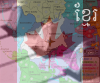
Update - March 10
With Army Shadows

Without Army Shadows

Changes made this update
- Reduced font size
- Removed shadow from behind text
- Reduced continent label size and depth
- Added back a bit more variation to continent colours
- Changed colour of dead territory
- Added an option without army shadows
Comments
I kept water the colour it is, just doesn't look right blue in my opinion. I'll post up an option with blue water if it's still wanted though.
I haven't been able to come up with satisfactory edges or a legend yet, I just can't get either of these things right.
Things I did do though were to reduce the font size and put up an option without the army shadows as it was looking a little crowded. I attempted to fix some colour issues as well... making the dead territory darker and putting back some more variation in the continents. I also moved that Cyprus shadow as well, hopefully that clears things up.
When I first put this together I thought it looked empty without army shadows. With the mountains there now though, I prefer it without them. Comments?
With Army Shadows
Without Army Shadows
Changes made this update
- Reduced font size
- Removed shadow from behind text
- Reduced continent label size and depth
- Added back a bit more variation to continent colours
- Changed colour of dead territory
- Added an option without army shadows
Comments
I kept water the colour it is, just doesn't look right blue in my opinion. I'll post up an option with blue water if it's still wanted though.
I haven't been able to come up with satisfactory edges or a legend yet, I just can't get either of these things right.
Things I did do though were to reduce the font size and put up an option without the army shadows as it was looking a little crowded. I attempted to fix some colour issues as well... making the dead territory darker and putting back some more variation in the continents. I also moved that Cyprus shadow as well, hopefully that clears things up.
When I first put this together I thought it looked empty without army shadows. With the mountains there now though, I prefer it without them. Comments?
-
KEYOGI
- Posts: 1632
- Joined: Tue Oct 10, 2006 6:09 am

![]() by fluffybunnykins on Fri Mar 09, 2007 1:10 pm
by fluffybunnykins on Fri Mar 09, 2007 1:10 pm
Army shadows are only useful if the colour of the territory would make it hard to see the numbers. Absolutely unnecessary in this case, I think.
Maybe consider varying the curve that the continent names are written on for each one, so that they can navigate through some of the blanker areas, it'll make them more readable and possibly enhance the look & feel...
Nice looking map, I mean, really nice!
Maybe consider varying the curve that the continent names are written on for each one, so that they can navigate through some of the blanker areas, it'll make them more readable and possibly enhance the look & feel...
Nice looking map, I mean, really nice!
Superman wears 'Fluffybunnykins' pyjamas
-

fluffybunnykins
- Posts: 385
- Joined: Tue May 02, 2006 6:43 am
- Location: Liverpool, UK

![]() by spinwizard on Fri Mar 09, 2007 1:47 pm
by spinwizard on Fri Mar 09, 2007 1:47 pm
bedplay wrote:Here's an idea for you KEYOGI.
I've posted a link of an old map , with painted areas around the borders, if you used say...
yellow
dark green
light green
dark brown
light brown
& biege
(the exact colours you used for the first map you did)
That would look pretty good I think, plus it'd be easier to distinguish
you could even have them less obvious than you're 1st map if you differentiated between .eg. a greeny coulour adjacent to a yellowey colour to add more contrast between them.
can u try it with this!, keep everything the same colour (parchment) and the borders all colours (red, yellow, green, ect.)
-
spinwizard
- Posts: 5016
- Joined: Sun Dec 10, 2006 9:52 am
![]() by Enigma on Fri Mar 09, 2007 4:08 pm
by Enigma on Fri Mar 09, 2007 4:08 pm
labels look great 
i also like this map with army shadows, adds definition. i think it still looks a empty w/o them, even with the mountains.
dead territories look a lot better, maybe make them even darker?
another thought-- looking at bedplays pic- i really like the way qwert has used the graph paper idea as a background 4 his iwo jima map. maybe you could do something similar by adding longitude and latitude lines. that might help fill in some of the empty space in the larger territories, and maybe the army circles wouldnt be necessary. or maybe you could make the army circles just black lines which match the rest of the map, since you dont really need the interior of the circles lightened on this map.
another idea- use a thin calligraphy pen tip to draw the border lines. adds interest.
just suggestions, ideas to imitate the styles of the old maps.
Last edited by Enigma on Fri Mar 09, 2007 4:20 pm, edited 1 time in total.
Do you need an excuse to have a war? I mean, who for? Can't you just say "You got lots of cash and land, but I've got a big sword, so divy up right now, chop chop."
Terry Pratchet
Terry Pratchet
-

Enigma
- Posts: 367
- Joined: Mon Jul 03, 2006 10:23 pm
- Location: Classified


![]() by KEYOGI on Fri Mar 09, 2007 5:43 pm
by KEYOGI on Fri Mar 09, 2007 5:43 pm
Enigma wrote:maybe you could do something similar by adding longitude and latitude lines. that might help fill in some of the empty space in the larger territories, and maybe the army circles wouldnt be necessary. or maybe you could make the army circles just black lines which match the rest of the map, since you dont really need the interior of the circles lightened on this map.
another idea- use a thin calligraphy pen tip to draw the border lines. adds interest.
I tried the longitude and latitude lines before I got to the point of posting the map on the forums. I didn't like it.
I'm not sure the calligraphy pen is a good idea either, I think it'll just create confusion with lines of different thickness. I'll see what the concensus is on the army shadows though, I think I might lean that way... similar to the Middle Earth map.
Molacole wrote:instead of filling in the bonuses with color are you going to just highlight the border lines with a color?
Definately for next update.
-
KEYOGI
- Posts: 1632
- Joined: Tue Oct 10, 2006 6:09 am
![]() by KEYOGI on Sat Mar 10, 2007 2:42 am
by KEYOGI on Sat Mar 10, 2007 2:42 am

That's a taste of what to expect, I just wanted to make sure that's the direction people want to take this before I go putting a whole heap of hours into it.
I also thought about the option of having the same highlight for each territory, not just the continents, but using a thinner highlight. Opinions?
Are people happy with the font? I'm still not 100% on it and was thinking of trying the Aniron font from http://www.dafont.com/aniron.font. A bit of Lord of The Rings inspiration.
-
KEYOGI
- Posts: 1632
- Joined: Tue Oct 10, 2006 6:09 am


![]() by Bad Speler on Sat Mar 10, 2007 11:02 am
by Bad Speler on Sat Mar 10, 2007 11:02 am
thats exactly what you need. I say just put that coloured outline around the entire continent, not countries
Might want to check out this font:
http://www.dafont.com/english.font
Might want to check out this font:
http://www.dafont.com/english.font
Highest Score: 2532
Highest Position: 69 (a long time ago)
Highest Position: 69 (a long time ago)
-
Bad Speler
- Posts: 1027
- Joined: Fri Jun 02, 2006 8:16 pm
- Location: Ottawa


![]() by Guiscard on Sat Mar 10, 2007 11:30 am
by Guiscard on Sat Mar 10, 2007 11:30 am
Yeh definitely those borders are the way to go...
I'd have them fading out slightly rather than a block, though (if you get me).
I'd have them fading out slightly rather than a block, though (if you get me).
qwert wrote:Can i ask you something?What is porpose for you to open these Political topic in ConquerClub? Why you mix politic with Risk? Why you not open topic like HOT AND SEXY,or something like that.
-
Guiscard
- Posts: 4103
- Joined: Fri Dec 08, 2006 7:27 pm
- Location: In the bar... With my head on the bar

![]() by Enigma on Sat Mar 10, 2007 1:14 pm
by Enigma on Sat Mar 10, 2007 1:14 pm
Bad Speler wrote:thats exactly what you need. I say just put that coloured outline around the entire continent, not countries
Might want to check out this font:
http://www.dafont.com/english.font
i agree. really like the outline, but not around territories.
badspeler, i think that english font will be unreadable as labels.
the current font is good, but i agree keyogi, the aniron font might be even better.
Do you need an excuse to have a war? I mean, who for? Can't you just say "You got lots of cash and land, but I've got a big sword, so divy up right now, chop chop."
Terry Pratchet
Terry Pratchet
-
Enigma
- Posts: 367
- Joined: Mon Jul 03, 2006 10:23 pm
- Location: Classified
![]() by DiM on Sat Mar 10, 2007 10:09 pm
by DiM on Sat Mar 10, 2007 10:09 pm
KEYOGI wrote:
do what guiscard said. fade the colour this way it will look better and also at the corners where the colour overlaps there will be no darker shades.
if you look closely there are some darker regions (like the one below the Jordan army circle)
PS: quench it. (i think this is the first post where i said a map needs to be quenched). this was a true inspiration for my 2 maps (especially the Age of Merchants one) i really like the way it looks and feels. it's like i almost want to touch it.
“In the beginning God said, the four-dimensional divergence of an antisymmetric, second rank tensor equals zero, and there was light, and it was good. And on the seventh day he rested.”- Michio Kaku
-

DiM
- Posts: 10415
- Joined: Wed Feb 14, 2007 6:20 pm
- Location: making maps for scooby snacks


![]() by Enigma on Sat Mar 10, 2007 11:10 pm
by Enigma on Sat Mar 10, 2007 11:10 pm
DiM wrote:KEYOGI wrote:
do what guiscard said. fade the colour this way it will look better and also at the corners where the colour overlaps there will be no darker shades.
if you look closely there are some darker regions (like the one below the Jordan army circle)
PS: quench it. (i think this is the first post where i said a map needs to be quenched). this was a true inspiration for my 2 maps (especially the Age of Merchants one) i really like the way it looks and feels. it's like i almost want to touch it.
actually i liked the overlap w/ the slightly darker corners. gives it a more hand drawn appearance.
Do you need an excuse to have a war? I mean, who for? Can't you just say "You got lots of cash and land, but I've got a big sword, so divy up right now, chop chop."
Terry Pratchet
Terry Pratchet
-
Enigma
- Posts: 367
- Joined: Mon Jul 03, 2006 10:23 pm
- Location: Classified
Who is online
Users browsing this forum: No registered users
|
|||||||
| Conquer Club is not associated with RISK online in any way. Copyright © 2006-2025 by Big Wham LLC | |||||||