MÉXICO [BETA] p1/18 --Sep 11th--
Moderator: Cartographers
Re: MEXICO [D, GP] p1/17 --Sep 3rd--
![]() by MrBenn on Fri Sep 03, 2010 5:05 pm
by MrBenn on Fri Sep 03, 2010 5:05 pm
Well, given that I've only adjusted the glow extending from the shoreline for about 10-15 pixels, I don;t really know why you suddenly think that bit of shading looks so bad (compare it to the large image at the top, and you'll see no real difference to that area.

PB: 2661 | He's blue... If he were green he would die | No mod would be stupid enough to do that
-

 MrBenn
- Posts: 6880
- Joined: Wed Nov 21, 2007 9:32 am
- Location: Off Duty


Re: MEXICO [D, GP] p1/17 --Sep 3rd--
![]() by natty dread on Fri Sep 03, 2010 5:13 pm
by natty dread on Fri Sep 03, 2010 5:13 pm
I'm sorry, I'm just saying how it looks to me.

-

natty dread
- Posts: 12877
- Joined: Fri Feb 08, 2008 8:58 pm
- Location: just plain fucked


Re: MEXICO [D, GP] p1/17 --Sep 3rd--
![]() by RedBaron0 on Tue Sep 07, 2010 2:15 am
by RedBaron0 on Tue Sep 07, 2010 2:15 am
Well.... I'm not saying the glow on the coast isn't bad, but I think the map was better without it.


-

RedBaron0
- Posts: 2657
- Joined: Sun Aug 19, 2007 12:59 pm
- Location: Pennsylvania


Re: MEXICO [D, GP] p1/17 --Sep 3rd--
![]() by natty dread on Tue Sep 07, 2010 7:07 am
by natty dread on Tue Sep 07, 2010 7:07 am
MrBenn wrote:Well, given that I've only adjusted the glow extending from the shoreline for about 10-15 pixels, I don;t really know why you suddenly think that bit of shading looks so bad (compare it to the large image at the top, and you'll see no real difference to that area.
I think... at the previous version, the glow is thin enough to look like an outline instead of a glow, so it didn't bother me much. However now that you have made it wider it seems somehow disturbing... it doesn't quite fit with the graphics of the rest of the map... I can't quite put my finger on it. Perhaps indeed it reminds me of the oil spill too much, and thinking about the oil spill just makes me sad...
Perhaps if you were to blur the edges of the glow, smooth it out a bit, it wouldn't bother so much, it would still serve it's purpose but it would be less noticeable.
Also, a very small nitpick: could it be possible to move the "Mountains are impassable" text down 1-2 pixels, so the letter U doesn't overlap with the land border?
-
natty dread
- Posts: 12877
- Joined: Fri Feb 08, 2008 8:58 pm
- Location: just plain fucked
Re: MEXICO [D, GP] p1/17 --Sep 3rd--
![]() by Victor Sullivan on Tue Sep 07, 2010 2:47 pm
by Victor Sullivan on Tue Sep 07, 2010 2:47 pm
natty_dread wrote:Also, a very small nitpick: could it be possible to move the "Mountains are impassable" text down 1-2 pixels, so the letter U doesn't overlap with the land border?
You think you'd be able to squeeze that into the legend somehow? I never even realized it was there until nutty said something and even at that it took me a bit to find it. Granted, the "mountains are impassable" thing is pretty much a given in any map so its movement may not be necessary.
-Sully
Beckytheblondie: "Don't give us the dispatch, give us a mustache ride."
Scaling back on my CC involvement...
Scaling back on my CC involvement...
-

Victor Sullivan
- Posts: 6010
- Joined: Mon Feb 08, 2010 8:17 pm
- Location: Columbus, OH


Re: MEXICO [D, GP] p1/17 --Sep 3rd--
![]() by MrBenn on Thu Sep 09, 2010 3:16 pm
by MrBenn on Thu Sep 09, 2010 3:16 pm
Is this any better?
- Click image to enlarge.

PB: 2661 | He's blue... If he were green he would die | No mod would be stupid enough to do that
-
MrBenn
- Posts: 6880
- Joined: Wed Nov 21, 2007 9:32 am
- Location: Off Duty
Re: MEXICO [D, GP] p1/17 --Sep 3rd--
![]() by Victor Sullivan on Thu Sep 09, 2010 4:37 pm
by Victor Sullivan on Thu Sep 09, 2010 4:37 pm
Looks good. Just noticed the neat designs in the water, it's kinda cool. On to FF, I say!
Beckytheblondie: "Don't give us the dispatch, give us a mustache ride."
Scaling back on my CC involvement...
Scaling back on my CC involvement...
-
Victor Sullivan
- Posts: 6010
- Joined: Mon Feb 08, 2010 8:17 pm
- Location: Columbus, OH
Re: MEXICO [D, GP] p1/17 --Sep 3rd--
![]() by RedBaron0 on Thu Sep 09, 2010 10:12 pm
by RedBaron0 on Thu Sep 09, 2010 10:12 pm
Lookin good, and the small map?
-
RedBaron0
- Posts: 2657
- Joined: Sun Aug 19, 2007 12:59 pm
- Location: Pennsylvania
Re: MEXICO [D, GP] p1/17 --Sep 3rd--
![]() by Victor Sullivan on Fri Sep 10, 2010 5:38 am
by Victor Sullivan on Fri Sep 10, 2010 5:38 am
Ah, good point. I guess I missed that 
Beckytheblondie: "Don't give us the dispatch, give us a mustache ride."
Scaling back on my CC involvement...
Scaling back on my CC involvement...
-
Victor Sullivan
- Posts: 6010
- Joined: Mon Feb 08, 2010 8:17 pm
- Location: Columbus, OH
Re: MEXICO [D, GP] p1/17 --Sep 3rd--
![]() by MrBenn on Fri Sep 10, 2010 4:48 pm
by MrBenn on Fri Sep 10, 2010 4:48 pm
RedBaron0 wrote:Lookin good, and the small map?
You know it'll be fine
PB: 2661 | He's blue... If he were green he would die | No mod would be stupid enough to do that
-
MrBenn
- Posts: 6880
- Joined: Wed Nov 21, 2007 9:32 am
- Location: Off Duty
Re: MEXICO [D, GP] p1/17 --Sep 3rd--
![]() by natty dread on Fri Sep 10, 2010 5:51 pm
by natty dread on Fri Sep 10, 2010 5:51 pm
Looks good... but I still think the "mountains are impassable" text could be moved 1-2 pixels down.
Also, perhaps the Tabasco territory label could be moved further to the sea so the army number will fit better?
Also, perhaps the Tabasco territory label could be moved further to the sea so the army number will fit better?
-
natty dread
- Posts: 12877
- Joined: Fri Feb 08, 2008 8:58 pm
- Location: just plain fucked
Re: MEXICO [D, GP] p1/17 --Sep 3rd--
![]() by RedBaron0 on Sat Sep 11, 2010 1:24 am
by RedBaron0 on Sat Sep 11, 2010 1:24 am
Looks like the last little bits are simple fixes. One last concern from me is Veracruz having the port of Veracruz bordering it. The two territories could be very-very confusing if they have the same name in the XML. I recommend changing the name on the map to "Port of Veracruz" for the port as well.

-
RedBaron0
- Posts: 2657
- Joined: Sun Aug 19, 2007 12:59 pm
- Location: Pennsylvania
Re: MEXICO [D, GP] p1/17 --Sep 3rd--
![]() by The Bison King on Sat Sep 11, 2010 2:08 am
by The Bison King on Sat Sep 11, 2010 2:08 am
I recommend changing the name on the map to "Port of Veracruz" for the port as wel
I agree with this.
RedBaron0 wrote:Image
Congrats I'm looking forward to this! Mexico is so necessary.

-

The Bison King
- Posts: 1957
- Joined: Thu Aug 27, 2009 5:06 pm
- Location: the Mid-Westeros


Re: MEXICO [D, GP] p1/17 --Sep 3rd--
![]() by men chuch! on Sat Sep 11, 2010 3:50 pm
by men chuch! on Sat Sep 11, 2010 3:50 pm
When we will be able to play it?
-

men chuch!
- Posts: 29
- Joined: Fri Jul 20, 2007 11:44 pm
Re: MEXICO [D, GP] p1/18 --Sep 11th--
![]() by MrBenn on Sat Sep 11, 2010 5:53 pm
by MrBenn on Sat Sep 11, 2010 5:53 pm
men chuch! wrote:When we will be able to play it?
Hopefully it won't be too long
Here are the (hopefully) final images:
- Click image to enlarge.
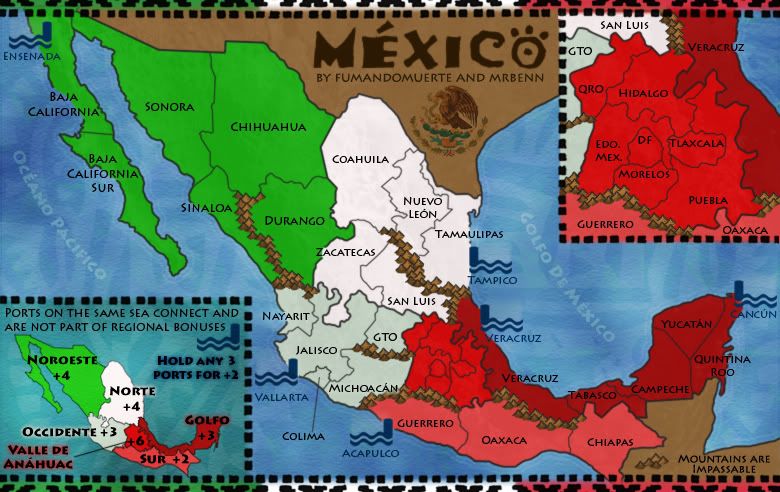
- Click image to enlarge.

PB: 2661 | He's blue... If he were green he would die | No mod would be stupid enough to do that
-
MrBenn
- Posts: 6880
- Joined: Wed Nov 21, 2007 9:32 am
- Location: Off Duty
Re: MÉXICO [D, GP, GR] p1/18 --Sep 11th--
![]() by Victor Sullivan on Sat Sep 11, 2010 5:59 pm
by Victor Sullivan on Sat Sep 11, 2010 5:59 pm
¡Muy bien! 
Beckytheblondie: "Don't give us the dispatch, give us a mustache ride."
Scaling back on my CC involvement...
Scaling back on my CC involvement...
-
Victor Sullivan
- Posts: 6010
- Joined: Mon Feb 08, 2010 8:17 pm
- Location: Columbus, OH
Re: MÉXICO [D, GP, GR] p1/18 --Sep 11th--
![]() by Victor Sullivan on Sat Sep 11, 2010 6:00 pm
by Victor Sullivan on Sat Sep 11, 2010 6:00 pm
Jeez I'm salivating in anticipation 
Beckytheblondie: "Don't give us the dispatch, give us a mustache ride."
Scaling back on my CC involvement...
Scaling back on my CC involvement...
-
Victor Sullivan
- Posts: 6010
- Joined: Mon Feb 08, 2010 8:17 pm
- Location: Columbus, OH
Re: MEXICO [D, GP] p1/17 --Sep 3rd--
![]() by natty dread on Sat Sep 11, 2010 6:02 pm
by natty dread on Sat Sep 11, 2010 6:02 pm
Very nice, but...
natty_dread wrote:perhaps the Tabasco territory label could be moved further to the sea so the army number will fit better?
-
natty dread
- Posts: 12877
- Joined: Fri Feb 08, 2008 8:58 pm
- Location: just plain fucked
Re: MEXICO [D, GP] p1/17 --Sep 3rd--
![]() by Victor Sullivan on Sat Sep 11, 2010 6:04 pm
by Victor Sullivan on Sat Sep 11, 2010 6:04 pm
natty_dread wrote:Very nice, but...natty_dread wrote:perhaps the Tabasco territory label could be moved further to the sea so the army number will fit better?
Too true, but he did move the impassables thing down.
Beckytheblondie: "Don't give us the dispatch, give us a mustache ride."
Scaling back on my CC involvement...
Scaling back on my CC involvement...
-
Victor Sullivan
- Posts: 6010
- Joined: Mon Feb 08, 2010 8:17 pm
- Location: Columbus, OH
Re: MÉXICO [D, GP, GR] p1/18 --Sep 11th--
![]() by natty dread on Sat Sep 11, 2010 6:06 pm
by natty dread on Sat Sep 11, 2010 6:06 pm
yes, but observe:
not an optimal number placement imo...
- Click image to enlarge.

not an optimal number placement imo...
-
natty dread
- Posts: 12877
- Joined: Fri Feb 08, 2008 8:58 pm
- Location: just plain fucked
Re: MÉXICO [D, GP, GR] p1/18 --Sep 11th--
![]() by Victor Sullivan on Sat Sep 11, 2010 6:19 pm
by Victor Sullivan on Sat Sep 11, 2010 6:19 pm
natty_dread wrote:yes, but observe:
- Click image to enlarge.
not an optimal number placement imo...
But I mean then the label would be either awkwardly out in the water or invading Campeche or Veracruz.
Beckytheblondie: "Don't give us the dispatch, give us a mustache ride."
Scaling back on my CC involvement...
Scaling back on my CC involvement...
-
Victor Sullivan
- Posts: 6010
- Joined: Mon Feb 08, 2010 8:17 pm
- Location: Columbus, OH
Re: MÉXICO [D, GP, GR] p1/18 --Sep 11th--
![]() by natty dread on Sat Sep 11, 2010 6:36 pm
by natty dread on Sat Sep 11, 2010 6:36 pm
There are already labels in the sea. It's better to have the label in the sea than have the army number cover up borders.
-
natty dread
- Posts: 12877
- Joined: Fri Feb 08, 2008 8:58 pm
- Location: just plain fucked
Re: MÉXICO [D, GP, GR] p1/18 --Sep 11th--
![]() by MrBenn on Sat Sep 11, 2010 6:55 pm
by MrBenn on Sat Sep 11, 2010 6:55 pm
The number will be in the water. I'll post images shortly.
I've just realised that the M of Michoacan is covering the border with Colima on the small map. I'll have to fix that <huff>
I've just realised that the M of Michoacan is covering the border with Colima on the small map. I'll have to fix that <huff>
PB: 2661 | He's blue... If he were green he would die | No mod would be stupid enough to do that
-
MrBenn
- Posts: 6880
- Joined: Wed Nov 21, 2007 9:32 am
- Location: Off Duty
Re: MÉXICO [D, GP, GR] p1/18 --Sep 11th--
![]() by MrBenn on Sat Sep 11, 2010 7:09 pm
by MrBenn on Sat Sep 11, 2010 7:09 pm
Here's the XML (which passes validation): http://www.fileden.com/files/2009/1/9/2259283//Mexico1.xml
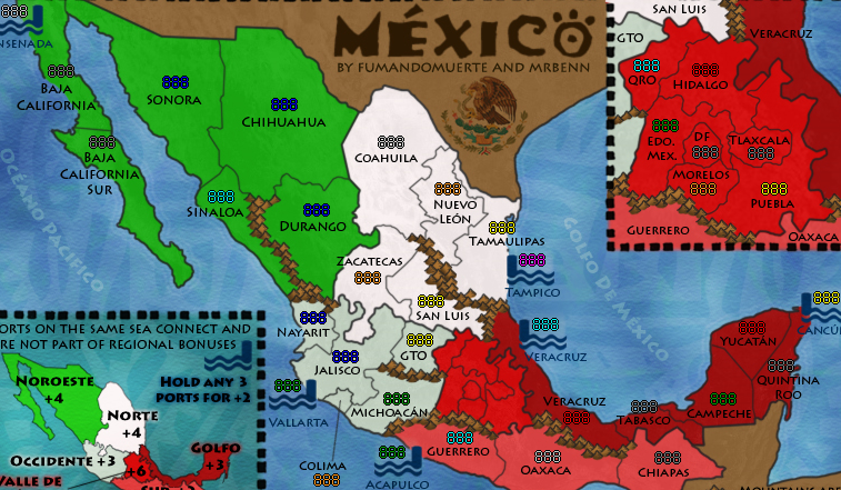
Images with 888s:
Images with 888s:
- Click image to enlarge.
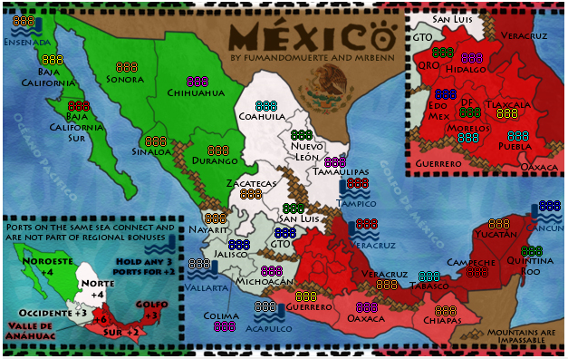
- Click image to enlarge.
PB: 2661 | He's blue... If he were green he would die | No mod would be stupid enough to do that
-
MrBenn
- Posts: 6880
- Joined: Wed Nov 21, 2007 9:32 am
- Location: Off Duty
Re: MÉXICO [D, GP, GR] p1/18 --Sep 11th--
![]() by MrBenn on Sat Sep 11, 2010 7:17 pm
by MrBenn on Sat Sep 11, 2010 7:17 pm
MrBenn wrote:I've just realised that the M of Michoacan is covering the border with Colima on the small map. I'll have to fix that <huff>
Fixed in the images on the previous page (but not on the screenshots with the 888s)
Here are all the map files:
XML: http://www.fileden.com/files/2009/1/9/2259283//Mexico1.xml
Small Image: http://i275.photobucket.com/albums/jj320/bpawley/mexico/Mexico14s.jpg
Large Image: http://i275.photobucket.com/albums/jj320/bpawley/mexico/Mexico14.jpg
PB: 2661 | He's blue... If he were green he would die | No mod would be stupid enough to do that
-
MrBenn
- Posts: 6880
- Joined: Wed Nov 21, 2007 9:32 am
- Location: Off Duty
Who is online
Users browsing this forum: No registered users
|
|||||||
| Conquer Club is not associated with RISK online in any way. Copyright © 2006-2025 by Big Wham LLC | |||||||