Thailand
Moderator: Cartographers
Re: Thailand [GP]
![]() by grifftron on Wed Jan 12, 2011 11:53 pm
by grifftron on Wed Jan 12, 2011 11:53 pm
edit
Last edited by grifftron on Thu Jan 13, 2011 3:28 am, edited 1 time in total.

-

 grifftron
- SoC Training Adviser
- Posts: 3280
- Joined: Thu Jul 09, 2009 6:11 am


Re: Thailand [GP]
![]() by FarangDemon on Thu Jan 13, 2011 2:48 am
by FarangDemon on Thu Jan 13, 2011 2:48 am
The Bison King wrote:The border of Buriram doesn't fully connect to Khon Kaen.
Yes I can see it in the large map, there is a small gap in the border separating Buriram from Khorat just before it meets Khon Kaen.
One other issue - please add some sort of connecting line between Phuket and Phang Nga. Also, if you think it would look ok, please add one between Phuket and Krabi, as there are frequent boat connections between those provinces. If you think it would look bad, we don't need it.
Cheers, looking very good! I'll have the xml done soon.
- Click image to enlarge.

"He came dancin across the water.... FarangDemon, FarangDemon.... mmmhh....what a killer..."
-

FarangDemon
- Posts: 700
- Joined: Wed Apr 23, 2008 1:36 am


Re: Thailand [GP]
![]() by grifftron on Thu Jan 13, 2011 3:11 am
by grifftron on Thu Jan 13, 2011 3:11 am
FarangDemon wrote:The Bison King wrote:The border of Buriram doesn't fully connect to Khon Kaen.
Yes I can see it in the large map, there is a small gap in the border separating Buriram from Khorat just before it meets Khon Kaen.
One other issue - please add some sort of connecting line between Phuket and Phang Nga. Also, if you think it would look ok, please add one between Phuket and Krabi, as there are frequent boat connections between those provinces. If you think it would look bad, we don't need it.
Cheers, looking very good! I'll have the xml done soon.
Good idea with the connections, i am surprised that wasn't discussed earlier.. the draft above is crap, i will have to redo it when i actually get time to sit down and do something. Thanks FD
edit: actually i messed it up, i saved over the big version with the small version on the psd file, i might have to redo it, i am hating the look of the small version of the map, especially the names, they are WAY to blurry
-griff
-
grifftron
- SoC Training Adviser
- Posts: 3280
- Joined: Thu Jul 09, 2009 6:11 am
Re: Thailand [GP]
![]() by grifftron on Thu Jan 13, 2011 4:13 am
by grifftron on Thu Jan 13, 2011 4:13 am
Big:
Small:
small version will have to re do the names, still blurry but it is looking better then before i think
edit: And the 888's on the small version
-griff
- Click image to enlarge.

Small:
- Click image to enlarge.

small version will have to re do the names, still blurry but it is looking better then before i think
edit: And the 888's on the small version
- Click image to enlarge.

-griff
-
grifftron
- SoC Training Adviser
- Posts: 3280
- Joined: Thu Jul 09, 2009 6:11 am
Re: Thailand [GP]
![]() by AndyDufresne on Fri Jan 14, 2011 1:22 pm
by AndyDufresne on Fri Jan 14, 2011 1:22 pm
Should 'territory abbreviations' be 'region abbreviations'---since you reference 'regions' in the other legend?
Looking at the small, I wish the text could be boosted a bit, or bolder. Otherwise I'm liking the map.
--Andy
Looking at the small, I wish the text could be boosted a bit, or bolder. Otherwise I'm liking the map.
--Andy
-

AndyDufresne
- Posts: 24935
- Joined: Fri Mar 03, 2006 8:22 pm
- Location: A Banana Palm in Zihuatanejo


Re: Thailand [GP]
![]() by grifftron on Sat Jan 15, 2011 12:02 am
by grifftron on Sat Jan 15, 2011 12:02 am
AndyDufresne wrote:Should 'territory abbreviations' be 'region abbreviations'---since you reference 'regions' in the other legend?
Looking at the small, I wish the text could be boosted a bit, or bolder. Otherwise I'm liking the map.
--Andy
Sounds good to me, i will change that on the next update...
I am planning on messing with the small version text, i was just wondering what everyone thought about the large version first before messing with the small version, it gets tricky now that i have to work with 2 different versions because of the text change.
-griff
-
grifftron
- SoC Training Adviser
- Posts: 3280
- Joined: Thu Jul 09, 2009 6:11 am
Re: Thailand [GP]
![]() by FarangDemon on Tue Jan 18, 2011 4:22 am
by FarangDemon on Tue Jan 18, 2011 4:22 am
I've pretty much finished the xml for the large Thailand map. Just need to fine tune the starting locations, which I'll do later.
If anybody wants an xml sneak preview of large map:
http://www.conquerclub.com/mapmaker/index.php
xml URL - http://www.killersapp.com/thailand.xml
map URL - http://farm6.static.flickr.com/5208/5351070881_56920f9d6b_b.jpg
If anybody wants an xml sneak preview of large map:
http://www.conquerclub.com/mapmaker/index.php
xml URL - http://www.killersapp.com/thailand.xml
map URL - http://farm6.static.flickr.com/5208/5351070881_56920f9d6b_b.jpg
- Click image to enlarge.
"He came dancin across the water.... FarangDemon, FarangDemon.... mmmhh....what a killer..."
-
FarangDemon
- Posts: 700
- Joined: Wed Apr 23, 2008 1:36 am
Re: Thailand [GP]
![]() by grifftron on Tue Jan 18, 2011 9:26 pm
by grifftron on Tue Jan 18, 2011 9:26 pm
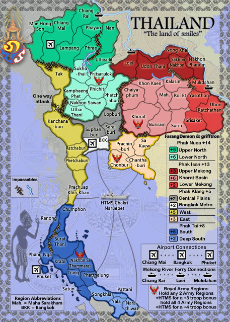
Large version

Small version
changed the text on the small version, it looked a lot clearer to me, let me know. Also changed from Tert Abrv. to Region Abrv on the key like Andy suggested above.
-griff
Small version
- Click image to enlarge.

changed the text on the small version, it looked a lot clearer to me, let me know. Also changed from Tert Abrv. to Region Abrv on the key like Andy suggested above.
-griff
-
grifftron
- SoC Training Adviser
- Posts: 3280
- Joined: Thu Jul 09, 2009 6:11 am
Re: Thailand [GP]
![]() by FarangDemon on Wed Jan 19, 2011 12:42 am
by FarangDemon on Wed Jan 19, 2011 12:42 am
One additional spelling edit I noticed when coding xml - should be "Phak Nuea" instead of "Phak Nua".
- Click image to enlarge.
"He came dancin across the water.... FarangDemon, FarangDemon.... mmmhh....what a killer..."
-
FarangDemon
- Posts: 700
- Joined: Wed Apr 23, 2008 1:36 am
Re: Thailand [GP]
![]() by grifftron on Wed Jan 19, 2011 8:20 am
by grifftron on Wed Jan 19, 2011 8:20 am
FarangDemon wrote:One additional spelling edit I noticed when coding xml - should be "Phak Nuea" instead of "Phak Nua".
changed.
Large version
- Click image to enlarge.

Small version
- Click image to enlarge.

-
grifftron
- SoC Training Adviser
- Posts: 3280
- Joined: Thu Jul 09, 2009 6:11 am
Re: Thailand [GP]
![]() by AndyDufresne on Wed Jan 19, 2011 11:53 am
by AndyDufresne on Wed Jan 19, 2011 11:53 am
The region names on the small map appear readable. The legend is a little fuzzy, but otherwise I don't have too many complaints about the map.
--Andy
--Andy
-
AndyDufresne
- Posts: 24935
- Joined: Fri Mar 03, 2006 8:22 pm
- Location: A Banana Palm in Zihuatanejo


Re: Thailand [GP]
![]() by grifftron on Wed Jan 19, 2011 8:37 pm
by grifftron on Wed Jan 19, 2011 8:37 pm
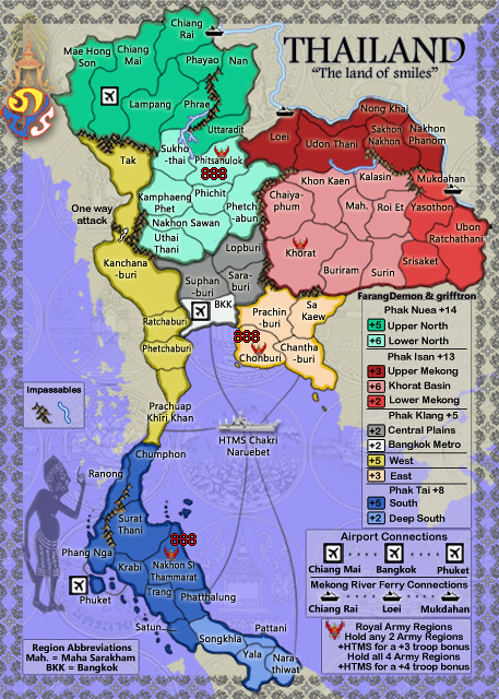
Nola_Lifer wrote:Where is your 888's on Phrae?
- Click image to enlarge.

And thanks andy, i will work more on the text in the key in just a bit here, i am too seeing the fuzzy.
-griff
-
grifftron
- SoC Training Adviser
- Posts: 3280
- Joined: Thu Jul 09, 2009 6:11 am
Re: Thailand [GP]
![]() by grifftron on Wed Jan 19, 2011 9:13 pm
by grifftron on Wed Jan 19, 2011 9:13 pm
Its clear now. I am going to Chiang Rai today, be back in a few.
-griff
- Click image to enlarge.

-griff
-
grifftron
- SoC Training Adviser
- Posts: 3280
- Joined: Thu Jul 09, 2009 6:11 am
Re: Thailand [GP]
![]() by RedBaron0 on Sun Jan 23, 2011 2:37 am
by RedBaron0 on Sun Jan 23, 2011 2:37 am
Looking pretty good Griff, there are a couple territory names that are getting lost in their borders. Ratchaburi, Phechiburi, and Narathlwat stick out to me the most. A little moving around or maybe just a little erasing of the borders directly under the territory name just to make sure everything is readable.
Give a check of your image on vischeck to make sure anyone with color blindness won't have much trouble viewing the map. http://www.vischeck.com/vischeck/vischeckImage.php
Give a check of your image on vischeck to make sure anyone with color blindness won't have much trouble viewing the map. http://www.vischeck.com/vischeck/vischeckImage.php


-

RedBaron0
- Posts: 2657
- Joined: Sun Aug 19, 2007 12:59 pm
- Location: Pennsylvania


Re: Thailand [GP]
![]() by grifftron on Sun Jan 23, 2011 8:30 am
by grifftron on Sun Jan 23, 2011 8:30 am
RedBaron0 wrote:Looking pretty good Griff, there are a couple territory names that are getting lost in their borders. Ratchaburi, Phechiburi, and Narathlwat stick out to me the most. A little moving around or maybe just a little erasing of the borders directly under the territory name just to make sure everything is readable.
Give a check of your image on vischeck to make sure anyone with color blindness won't have much trouble viewing the map. http://www.vischeck.com/vischeck/vischeckImage.php
- Click image to enlarge.

- Click image to enlarge.

should be fine i think, its pretty clear what belongs to what, and the shades of gray are all a little different. Clear to me at least.
-griff
Last edited by grifftron on Sun Jan 23, 2011 8:58 am, edited 1 time in total.
-
grifftron
- SoC Training Adviser
- Posts: 3280
- Joined: Thu Jul 09, 2009 6:11 am
Re: Thailand [GP]
![]() by grifftron on Sun Jan 23, 2011 8:53 am
by grifftron on Sun Jan 23, 2011 8:53 am
small:
large:
Ok i just erased and fine tuned the boarders behind those names that were not so clear on both versions.
-griff
- Click image to enlarge.
large:
- Click image to enlarge.
Ok i just erased and fine tuned the boarders behind those names that were not so clear on both versions.
-griff
-
grifftron
- SoC Training Adviser
- Posts: 3280
- Joined: Thu Jul 09, 2009 6:11 am
Re: Thailand [GP]
![]() by RedBaron0 on Tue Jan 25, 2011 2:33 am
by RedBaron0 on Tue Jan 25, 2011 2:33 am
Ugh, the images are broken, you gotta save'um after you run a vischeck.
But you're right, distinct regions for color blind folks.
Please put up some armies numbers, graphically, and lets make sure the colors don't blend together too much, the red and blue numbers I'm most afraid of, other than that I think you're good with the army number colors.
But you're right, distinct regions for color blind folks.
Please put up some armies numbers, graphically, and lets make sure the colors don't blend together too much, the red and blue numbers I'm most afraid of, other than that I think you're good with the army number colors.
-
RedBaron0
- Posts: 2657
- Joined: Sun Aug 19, 2007 12:59 pm
- Location: Pennsylvania
Re: Thailand [GP]
![]() by grifftron on Tue Jan 25, 2011 8:58 am
by grifftron on Tue Jan 25, 2011 8:58 am
Here is what i got, looked good to me... let me know
org. small version w/ 888's
color blind versions w/ 888's (as above)
org. small version w/ 888's
- Click image to enlarge.

color blind versions w/ 888's (as above)
- Click image to enlarge.

- Click image to enlarge.

-
grifftron
- SoC Training Adviser
- Posts: 3280
- Joined: Thu Jul 09, 2009 6:11 am
Re: Thailand [GP]
![]() by AndyDufresne on Tue Jan 25, 2011 10:43 am
by AndyDufresne on Tue Jan 25, 2011 10:43 am
The only maybe unfortunate thing I see are a few of the troop counts over the Royal Army Region icons, but for the most part, I'm not sure that can be helped.
--Andy
--Andy
-
AndyDufresne
- Posts: 24935
- Joined: Fri Mar 03, 2006 8:22 pm
- Location: A Banana Palm in Zihuatanejo
Re: Thailand [GP]
![]() by grifftron on Tue Jan 25, 2011 8:06 pm
by grifftron on Tue Jan 25, 2011 8:06 pm
AndyDufresne wrote:The only maybe unfortunate thing I see are a few of the troop counts over the Royal Army Region icons, but for the most part, I'm not sure that can be helped.
--Andy
The digs could be moved a bit, I bet I could have at least half the icon show w the 888 on top if that is acceptable?
or even make the Royal Army Region icons smaller for the small version...
-
grifftron
- SoC Training Adviser
- Posts: 3280
- Joined: Thu Jul 09, 2009 6:11 am
Re: Thailand [GP]
![]() by grifftron on Wed Jan 26, 2011 12:27 am
by grifftron on Wed Jan 26, 2011 12:27 am
Actually the little Royal Army icons don't look bad on the small version IMO. Seems to fit the 888's in those areas a lot easier now. I reduced the size by 30% i think it was of those icons
-griff
- Click image to enlarge.

-griff
-
grifftron
- SoC Training Adviser
- Posts: 3280
- Joined: Thu Jul 09, 2009 6:11 am
Re: Thailand [GP]
![]() by Bruceswar on Wed Jan 26, 2011 12:51 am
by Bruceswar on Wed Jan 26, 2011 12:51 am
This map is looking good. Seems to all fit in also! Well done working in small areas.
Highest Rank: 26 Highest Score: 3480

-

Bruceswar
- Posts: 9713
- Joined: Sun Dec 23, 2007 12:36 am
- Location: Cow Pastures


Re: Thailand [GP]
![]() by RedBaron0 on Wed Jan 26, 2011 10:39 am
by RedBaron0 on Wed Jan 26, 2011 10:39 am
Alright a few things that are popping out for me, but your journey is coming close to it's end. 
The background could be a touch darker, or could use a smidge of glow.
The non-playable areas are different colors, make them all the same color, personally I like the color of Myanmar to the west.
The non-playable area to the south, Malaysia, is outlined where the rest of the non-playable areas are not. Looks better without the outline.
While the playable surface covers the outer border of the map, the rivers also are on top of this border. It's kinda odd for me to see, a geographic feature on top while everything else is under. Drop the rivers below the outer border.
-
RedBaron0
- Posts: 2657
- Joined: Sun Aug 19, 2007 12:59 pm
- Location: Pennsylvania
Re: Thailand [GP]
![]() by grifftron on Thu Jan 27, 2011 1:36 am
by grifftron on Thu Jan 27, 2011 1:36 am
Big
Small
-griff
- Click image to enlarge.

Small
- Click image to enlarge.
-griff
-
grifftron
- SoC Training Adviser
- Posts: 3280
- Joined: Thu Jul 09, 2009 6:11 am
Who is online
Users browsing this forum: No registered users
|
|||||||
| Conquer Club is not associated with RISK online in any way. Copyright © 2006-2025 by Big Wham LLC | |||||||