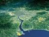
I believe it's called a montage. It's deliberate. Adds flavour/interest to the background and each type of image is deliberately chosen to illustrate a portion of the map. Top right - Taj/Mughals. Top - himalayas. Palms - Goa. Bottom - Fall of Tippu Sultan (Mysore, Deccan). Ship, Calcutta/colonials.johloh wrote:I think you want your background images to only occur in one of the areas around the map...
the way you have it now you have borders of pictures in the centers of some of the oceans...pick one image for each area (ex NE land, SE ocean) and try and stick to one image per area....with some blending in between two touching areas...
The borders between images have been blurred. I could blur them some more but I don't think it would improve the montage as there is always going to be a point where one image becomes another.
Kashmir - did that name exist then? Kashmir has a whole bunch of political issues that I'm keen to avoid, particularly as I have alternative names to use.darkmagus wrote:
At least it would have something to do with reality..
In case you forgot: that area was never controlled by the confederacy.. it was however for a while controlled by the sikh empire.
Why not call it Kashmir, then?
There was a Sikh Confederacy. It's not in the exact same place as the real one but it's in the general area of NW India, which is where the Sikh Confederacy was.
Sikh Empire would be less accurate than Sikh Confederacy as Sikh Empire was much larger area than Sikh Confederacy. It doesn't make sense to call one territory an "empire".


 [/url] Clicky Either One