
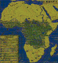
iancanton wrote:if there is room, then senegal can be changed to senegal & gambia (the senegambia confederation no longer exists, else we could have used that name) and zambia can be changed to zambia & malawi. i believe that uganda, rwanda & burundi will not fit the map, so it will have to stay as uganda. the purpose of removing mainland equatorial guinea from the map, while keeping the connections the same, was to avoid confusing players; it can be restored if there is a strong opinion about this and we find a good way to represent the country as one region.
Not done, I put the names in the big, but no way to fit them in the small. Moreover if we have to do that just for the sake. Honestly I think that for too long we have allowed to everyone to set as mandatory suggestion even if those didn't had a real technical purpose. This is not Nation Geographic nor a Carthograpy Industry, so we can have a map that is not exactly like reality, specially if it makes the map less cluttered.
iancanton wrote:são tomé has been misspelled as sao tomé in the xml and as sao tomè on both large and small maps. cote d'ivoire ought to be côte d'ivoire
Done, thanks ian.

btw i moved also a couple of names to fit better the new xml.
DoomYoshi wrote: I am wondering if you can change the 'interterritory' bridges to a different graphic from the 'intraterritory bridges'.
I get what you mean, but if i do that i have to add another legend, this because I know that someone with zero brain will come here and say....why you have 2 different bridges? can you explain what is the difference with a legend?....then we will finish to have a group of legends with a map. I had tu cut the map to a size i really dislike...I won't ruin this map anymore than this.
Now, can these versions and the new xml be uploaded or there's something else to fix/change?


](./images/smilies/eusa_wall.gif "Brick wall")


