Finally: South America map [Abandoned]
Moderator: Cartographers
71 posts
• Page 3 of 3 • 1, 2, 3
![]() by joeyjordison on Tue Dec 19, 2006 1:23 pm
by joeyjordison on Tue Dec 19, 2006 1:23 pm
marvs been pretty busy lately. i am sure he will reply eventually
-

 joeyjordison
- Posts: 1170
- Joined: Wed Apr 19, 2006 9:10 am

![]() by Marvaddin on Tue Dec 19, 2006 5:57 pm
by Marvaddin on Tue Dec 19, 2006 5:57 pm
qwert, please dont post things about other maps in this thread, ok?
Dafranca, seu torcedor do fluzão, lol... I think your version wouldnt work better, but I intend to make a simple version of it, so people can compare. Yeah, I was very busy, with college and job, but happilly time to work on this map is coming again
Dafranca, seu torcedor do fluzão, lol... I think your version wouldnt work better, but I intend to make a simple version of it, so people can compare. Yeah, I was very busy, with college and job, but happilly time to work on this map is coming again

-

Marvaddin
- Posts: 2545
- Joined: Thu Feb 09, 2006 5:06 pm
- Location: Belo Horizonte, Brazil


![]() by Marvaddin on Sat Dec 23, 2006 11:15 am
by Marvaddin on Sat Dec 23, 2006 11:15 am
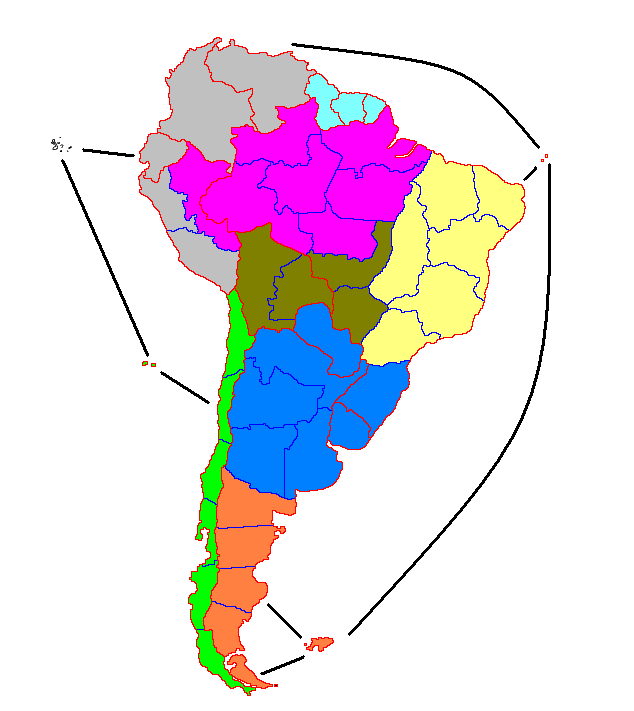
Version suggested by Dafranca. I dont think its better. As he didnt mention Manaus, I keep it in the pink region, but maybe he was thinking about merge it with another territory. Opinions?
-
Marvaddin
- Posts: 2545
- Joined: Thu Feb 09, 2006 5:06 pm
- Location: Belo Horizonte, Brazil
![]() by AndyDufresne on Sat Dec 23, 2006 3:13 pm
by AndyDufresne on Sat Dec 23, 2006 3:13 pm
To compare them both accurately...where would impassable borders (if any) be placed on Dafranca's map? Both are interesting, and I'd like to compare them, once I see that.
--Andy
--Andy
-

AndyDufresne
- Posts: 24935
- Joined: Fri Mar 03, 2006 8:22 pm
- Location: A Banana Palm in Zihuatanejo


![]() by Qwert on Sat Dec 23, 2006 3:58 pm
by Qwert on Sat Dec 23, 2006 3:58 pm
first i dont say name of maps.
Lett see yours map.
1.Grey teritory, yours umpasabile borders split these teritory in center, its no good. Move mauntin to be a border between countries.
2. you got to small countries pink, only 3 teritory.
3.Ad some way in middle chile for attack.
4.For backround put some pictures related for these continent.
These for begining.
-

Qwert
- SoC Training Adviser
- Posts: 9262
- Joined: Tue Nov 07, 2006 5:07 pm
- Location: VOJVODINA


![]() by Marvaddin on Sun Dec 24, 2006 6:03 am
by Marvaddin on Sun Dec 24, 2006 6:03 am
AndyDufresne wrote:To compare them both accurately...where would impassable borders (if any) be placed on Dafranca's map? Both are interesting, and I'd like to compare them, once I see that.
--Andy
I dont know about the impassable. We need ask him. The thing I think its interesting is the way North and South are easily connecte by ocean routes. I think I can study this...
-
Marvaddin
- Posts: 2545
- Joined: Thu Feb 09, 2006 5:06 pm
- Location: Belo Horizonte, Brazil
![]() by dafranca on Sun Dec 24, 2006 4:53 pm
by dafranca on Sun Dec 24, 2006 4:53 pm
I was looking into same maps, and I think is best to devide Colombia in two territories. Bogota(Altiplano/north Andes) and Vichada(amazon).
Join Valdovia with Santiago
Add the Island Sauth Georgia (connected with Foulkands only)
1 ) Patagonia (Foulkands, Tierra del Fuego, Santa Cruz, Chubut, Rio Negro and South Georgia) +3
2 ) Pampas (Cordoba, tucuman, Buenos Aires, Uruguay, Corrientes, Rio Grande and Paraguai) +4
3 ) Pantanal (La Paz, Santa Cruz, Cuiaba and Campo Grande) +2
4 ) Guianas (French Guiana, Guyana and Suriname) +1
5 ) Amazonas (Manaus, Aripuanã, Roraima, Acre, Loreto, Xingu, Belem and Vichada) +5
6 ) Chile ( Tarapaca, San Felix, Atacama, Santiago, Aisen and Magallanes) +3
7 ) East Brasil (Sao Paulo, Minas Gerais, Goias, Bahia, Maralhao, Ceara and Fernando de Noronha) +4
8 ) Altiplano (Arequipa, Lima, Equador, Galapagos, Bogota and Venezuela) +3
The best think is to try to work with natural hills and rivers.
1) Add the Andes, from Magallanes/Santa Cruz(close borders) up to Bogota/Vichada(close borders)
2) Add more Andes in Corrientes/La Paz, Paraguay/La paz and Paraguay/Santa Cruz and La Paz/Loreto. Make sure Santa Cruz doesn't make border with Acre.
2) Add Guianas High hill, from Guianas/Amazonas
3) Amazon River: this river should separete belem/ximbu, roraima manuas and roraima/acre. You could also make add bridge from Belem/Xingu.
4) Tocantins River: This river should separe maranhao/belem, maranhao/xingu, goiás/xingu
Borders Changes:
1) Corrientes should not touch Sao Paulo
2) Mamanhao should increase the border up to Tocantins River(Marajo Island, beside city of belem), so it can be separareted from Tocantins River
3) Make all borders black, except for real rivers.
4) The most imporatant thing, Instead of connecting Fernando de Noronha with Venezuela, connect it with Galapagos and connect San Felix with Falklands.
This map will be a bomb, It is going to be all about playability.
Last edited by dafranca on Wed Dec 27, 2006 3:11 am, edited 4 times in total.
-

dafranca
- Posts: 90
- Joined: Wed Nov 08, 2006 11:04 pm
![]() by reverend_kyle on Sun Dec 24, 2006 11:11 pm
by reverend_kyle on Sun Dec 24, 2006 11:11 pm
I will not comment once more til those insufferable blue lines are gone.
DANCING MUSTARD FOR POOP IN '08!
-

reverend_kyle
- Posts: 9250
- Joined: Tue Mar 21, 2006 4:08 pm
- Location: 1000 post club


![]() by Marvaddin on Wed Dec 27, 2006 1:44 am
by Marvaddin on Wed Dec 27, 2006 1:44 am
Well, before we continue discussing this map, I want to say why I dont like dafranca main scheme: real countries are too divided. See, Brazil is part of 4 continents, and only one has only Brazilian territories. I think we should try to maintain some real countries borders between the continents of the maps. I still can think about something like to split Argentina, although I dont really know if it would be a good idea.
What people think? Create something more related to real countries borders or no?
Ok, I will use another colour instead of blue borders
What people think? Create something more related to real countries borders or no?
Ok, I will use another colour instead of blue borders
-
Marvaddin
- Posts: 2545
- Joined: Thu Feb 09, 2006 5:06 pm
- Location: Belo Horizonte, Brazil
![]() by dafranca on Wed Dec 27, 2006 3:44 am
by dafranca on Wed Dec 27, 2006 3:44 am
Marvadin, you are a brasileiro, you know this country is big and very diverse. If you go to south Brasil you will feal like you are in other country, if you go to the north of Brasil you will see different people and different climate, different races, different economy. Think about it! Besides it will be much better for playability.
Sure, I devided in Geographic Regions:
Pampas
Patagonia
Altiplano
Amazon
Pantanal
Guianas
Marvaddin wrote:I want to say why I dont like dafranca main scheme:. See, Brazil is part of 4 continents, and only one has only Brazilian territories. I think we should try to maintain some real countries borders between the continents of the maps.
Sure, I devided in Geographic Regions:
Pampas
Patagonia
Altiplano
Amazon
Pantanal
Guianas
-
dafranca
- Posts: 90
- Joined: Wed Nov 08, 2006 11:04 pm
![]() by happysadfun on Wed Dec 27, 2006 1:02 pm
by happysadfun on Wed Dec 27, 2006 1:02 pm
You need better borders. A better colour scheme, and argentina and chile being non-linear. That would be good.
 Children, this is what happens to hockey players, druggies, and Hillary Clinton.
Rope. Tree. Hillary. Some assembly required.
-

happysadfun
- Posts: 1251
- Joined: Mon Jul 10, 2006 9:06 pm
- Location: Haundin at DotSco, Being Sad that Mark Green Lost in Suburban Wisconsin
![]() by AndyDufresne on Tue Jan 09, 2007 10:34 pm
by AndyDufresne on Tue Jan 09, 2007 10:34 pm
I remember I wanted to post regarding which one I liked, but I would've needed to see visual images of both possible map continent schemes...as having one in visuals and the other in words, does me no good.
--Andy
--Andy
-
AndyDufresne
- Posts: 24935
- Joined: Fri Mar 03, 2006 8:22 pm
- Location: A Banana Palm in Zihuatanejo
![]() by Qwert on Wed Jan 10, 2007 6:01 pm
by Qwert on Wed Jan 10, 2007 6:01 pm
qwert
Posted: 23 Dec 2006 20:58
--------------------------------------------------------------------------------
first i dont say name of maps.
Lett see yours map.
1.Grey teritory, yours umpasabile borders split these teritory in center, its no good. Move mauntin to be a border between countries.
2. you got to small countries pink, only 3 teritory.
3.Ad some way in middle chile for attack.
4.For backround put some pictures related for these continent.
These for begining.
Marvaddin wrote
--------------------------------------------------------------------------------
No more comments? So I think I will stay with my old continent scheme... But I will give some more time to comments...
-
Qwert
- SoC Training Adviser
- Posts: 9262
- Joined: Tue Nov 07, 2006 5:07 pm
- Location: VOJVODINA
![]() by Sargeant_Pepper on Mon Jun 18, 2007 2:29 pm
by Sargeant_Pepper on Mon Jun 18, 2007 2:29 pm
i like it! Needs a few naval attack routes.
Visit Felipe Alvarez's website.
-

Sargeant_Pepper
- Posts: 58
- Joined: Mon Jan 01, 2007 8:03 pm
![]() by unriggable on Mon Jun 18, 2007 3:40 pm
by unriggable on Mon Jun 18, 2007 3:40 pm
Sargeant_Pepper wrote:i like it! Needs a few naval attack routes.
Stop bumping these threads!

-

unriggable
- Posts: 8037
- Joined: Thu Feb 08, 2007 9:49 pm

![]() by PE24 on Thu Jun 21, 2007 10:46 am
by PE24 on Thu Jun 21, 2007 10:46 am
I was talking to my friends about how CC should have a South American map sonce there is a Northern Ameran map, and then I see this. Comvenient.
Anyway, I think this is a brilliant idea. The look of the map is okay, but I'm not going to criticise on what's already been criticised.
I hope to see this map as a playable one!
Anyway, I think this is a brilliant idea. The look of the map is okay, but I'm not going to criticise on what's already been criticised.
I hope to see this map as a playable one!

The Undertaker has sent his Army of Dust Mites towards your soul......beware!
-

PE24
- Posts: 231
- Joined: Fri Jan 12, 2007 11:52 am
- Location: Somewhere I belong...... wherever that may be.


-
thegeneralpublic
- Posts: 126
- Joined: Fri Mar 09, 2007 9:49 pm
- Location: In front of my computer screen.
71 posts
• Page 3 of 3 • 1, 2, 3
Return to Melting Pot: Map Ideas
Who is online
Users browsing this forum: No registered users
|
|||||||
| Conquer Club is not associated with RISK online in any way. Copyright © 2006-2025 by Big Wham LLC | |||||||