sorry man but i think background picture sucks.. like the idea though.map needs still a lot of work
edit: and since when is zagorje in slovenia.i know they talk alike but still
Former Yugoslavia [Abandoned]
Moderator: Cartographers
113 posts
• Page 5 of 5 • 1, 2, 3, 4, 5
![]() by mighty_serb on Wed Aug 01, 2007 7:21 pm
by mighty_serb on Wed Aug 01, 2007 7:21 pm
Coleman, what do you mean by texture?
Do you mean something like putting a geographical surface on territories?
Simonov, I know Zagorje is part of Croatia. Read the whole debate. It's about playability reasons. I know you Croats don't like it, but live with it. Europe map has whole Yugoslavia named 'Croatia', so that's how it is, it's a game, not a geography class. Plus, most non-Croats won't even notice this. Croatia is still C-shaped.
As for the picture, why does it suck???
-

 mighty_serb
- Posts: 35
- Joined: Wed Aug 09, 2006 9:08 pm


![]() by Coleman on Wed Aug 01, 2007 9:24 pm
by Coleman on Wed Aug 01, 2007 9:24 pm
mighty_serb wrote:As for the picture, why does it suck???
Because it is geographically and historically accurate? You got me.
By texture I mean something other then just a flat generic color. I'm not saying fill effects, but like... Aw hell I don't know. I'm not very artistically savy really. If you look at the montreal revamp. It's mostly solid colors but there is a texture in them, like a soft sandy sort of thing.
Warning: You may be reading a really old topic.
-

Coleman
- Posts: 5402
- Joined: Tue Jan 02, 2007 10:36 pm
- Location: Midwest


new
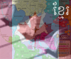
![]() by mighty_serb on Wed Aug 01, 2007 10:37 pm
by mighty_serb on Wed Aug 01, 2007 10:37 pm
Ok, I made those two territories bigger,
I added more stuff
and I added a texture.
Here is what it looks like now.

I added more stuff
and I added a texture.
Here is what it looks like now.
-
mighty_serb
- Posts: 35
- Joined: Wed Aug 09, 2006 9:08 pm
![]() by Bad Speler on Mon Aug 06, 2007 3:54 am
by Bad Speler on Mon Aug 06, 2007 3:54 am
Texture looks good, but I would consider reducing its strength/appearance in the unplayable areas.
The holes in the map don't look good especcially in the sea.
Overall, good looking map so far.
The holes in the map don't look good especcially in the sea.
Overall, good looking map so far.
Highest Score: 2532
Highest Position: 69 (a long time ago)
Highest Position: 69 (a long time ago)
-
Bad Speler
- Posts: 1027
- Joined: Fri Jun 02, 2006 8:16 pm
- Location: Ottawa


![]() by Qwert on Mon Aug 06, 2007 6:44 am
by Qwert on Mon Aug 06, 2007 6:44 am
First,its these map present Before war or after War.
I dont want to coment others republic,i just coment Serbia.
1.Why you put Kosovo in other colour?
2.Shape of Vojvodina is very strange.
3.Vojvodina have 3 district not 4.
4.Why you have barrier in Serbia.
5.Danube also have very strange shape to.
6.I dont like bullet holes on map.Also dont like these gray texture,try to find some more better background and something what will better present neutral country.(They have to many maps with these solution and i dont like these).
7.Do you know what names you will give Serbian terittory?
Im from Vojvodina(Serbia)so i will wach yours work,and i hope that you dont want to create map with some mistake.

-

Qwert
- SoC Training Adviser
- Posts: 9262
- Joined: Tue Nov 07, 2006 5:07 pm
- Location: VOJVODINA


Re: new
![]() by Simonov on Mon Aug 06, 2007 3:56 pm
by Simonov on Mon Aug 06, 2007 3:56 pm
mighty_serb wrote:
Here is what it looks like now.
hi i like this background better.i have suggestion about zagorje and playability problem.croatia is too big for this map and perhaps unholdable (too many borders).suggest you split croatia to coastal and continental part (which would include zagorje) don't see problem with slovenia having only 4 territories as montenegro and kosovo have only 3.and don't see hoe it improved playability in first place since it didn't really made it easier player to hold croatia(nmb of borders remained the same).could also make vojvodina a separate territory so one could hold "uža" serbia more easily.but i also suggest putting additional bonuses for hold both parts of croatia, both parts of b&h and narrow serbia, vojvodina and kosovo regions which are parts of serbia. i think this would resolve all problem on this map.
just to show you what i mean by dividing croatia and serbia:

keep up the good work.looking forward to play this map.
Last edited by Simonov on Mon Aug 06, 2007 4:43 pm, edited 3 times in total.
-
Simonov
- Posts: 976
- Joined: Fri Jul 13, 2007 12:56 pm
![]() by Simonov on Mon Aug 06, 2007 4:12 pm
by Simonov on Mon Aug 06, 2007 4:12 pm
one more comment.about rivers - una is not drawn properly so better remove it and sava seems to originate from croatian-slovenian border but it's source is in slovenia(check the maps). and also should add bridges on where it's necessery .lands that bring bonuses should be connected.
edit: could also put capitals of former republics on map and give additional bonus for holding a capital +1/turn.ljubljana, zagreb, sarajevo,titograd(now podgorica), belgrade and skopje.
here is the actual map:

hope i've been of some help to you.
edit: could also put capitals of former republics on map and give additional bonus for holding a capital +1/turn.ljubljana, zagreb, sarajevo,titograd(now podgorica), belgrade and skopje.
here is the actual map:
hope i've been of some help to you.
-
Simonov
- Posts: 976
- Joined: Fri Jul 13, 2007 12:56 pm
![]() by SWeko on Fri Aug 10, 2007 8:42 am
by SWeko on Fri Aug 10, 2007 8:42 am
I really like Simonov's idea...
There will be 10 Continents:
- Makedonija (1)
- Kosovo (2)
- Vojvodina (2)
- Uza Srbija (4)
- Bosna (3)
- Srpska (4)
- Continental Croatia (4)
- Dalmatia (4)
- Slovenia (2)
- Montenegro (2)
And we can make all sorts of other combinations of bonuses depending on continents held, like Srbija = Uza Srbija + Vojvodina + Kosovo, and Croatia = Continental + Dalmatia, or even something like Great Serbia = Srbija + Srpska + Montenegro + Macedonia, or, Iridenta=Kosovo + Montenegro + Macedonia.
Just one more nitpick, how come, the eastern part of macedonia is called Kriva Palanka?
-
SWeko
- Posts: 74
- Joined: Wed Jul 11, 2007 3:37 am


![]() by mighty_serb on Fri Aug 10, 2007 8:35 pm
by mighty_serb on Fri Aug 10, 2007 8:35 pm
Yeah I like Simonov's idea too.
Not sure how to squeeze in Capitals now, but I'll try.
I will get SWeko to help me out perhaps.
How come eastern part of macedonia is called Kriva Palanka? Because I tried looking up names by typing "regions in Macedonia" however I got nothing for eastern part. Maybe we should just call it Eastern Macedonia?
About rivers.. they are not properly drawn out, I know, but I tried to draw them along the territorial or state boundaries, so they could be used as a barrier (for hard-to keep continents like Srpska).
For qwert,
Kosovo is in other colour because it is under UN administration, not Serbia's administration. In other words, it is ruled by UN/NATO and not Serbia, even though 'geographically' it is still part of Serbia.
Shape of Vojvodina is very strange because I didn't look at Vojvodina as one region, but I looked at various municipalities within Serbia.
Why Barrier in Serbia? Playability reasons?
And yes, Danube has a strange shape, because all rivers do.
Bulletholes... will try to fix.
Grey texture seems to be just your preference. I like it (and some other people on here do) so I'll keep it gray.
For names of Serbian territory, check old maps. But I think I'll go with Simonov's idea.
-
mighty_serb
- Posts: 35
- Joined: Wed Aug 09, 2006 9:08 pm

Re: Former Yugoslavia [Abandoned]
![]() by cataphract on Tue Nov 24, 2009 1:26 pm
by cataphract on Tue Nov 24, 2009 1:26 pm
Hi guys... lets bring this topic back from the dead.... Whats the progress like on the Yug map?
Cheers
Cheers
-
cataphract
- Posts: 6
- Joined: Wed Aug 23, 2006 10:35 pm
- Location: Australia
113 posts
• Page 5 of 5 • 1, 2, 3, 4, 5
Return to Melting Pot: Map Ideas
Who is online
Users browsing this forum: No registered users
|
|||||||
| Conquer Club is not associated with RISK online in any way. Copyright © 2006-2025 by Big Wham LLC | |||||||