Golfe du St. Laurent[FD,G,GP,FF]
Moderator: Cartographers
Forum rules
Please read the Community Guidelines before posting.
Please read the Community Guidelines before posting.

any way that the Duplesis territory can be split into two territories? It would
• give you 32 terits instead of 31, which would eliminate neutrals in four and eight player games,
• give better balance to the region bonuses, since it'd be a four terit +3 like Labrador, and
• eliminate having a terit right in the middle of the map that promises to be smacked around more than a cheap piñata.
(It took great will power to keep that last comment clean.)
-
Unit_2

- Posts: 1834
- Joined: Sun Jan 14, 2007 12:59 pm
- Gender: Male
- Location: Pennsylvania, U.S.A, North America, Earth, Milky Way, Universe.
Well.. I can but its not a real territory, so it would be a made-up one.oaktown wrote:any way that the Duplesis territory can be split into two territories? It would
• give you 32 terits instead of 31, which would eliminate neutrals in four and eight player games,
• give better balance to the region bonuses, since it'd be a four terit +3 like Labrador, and
• eliminate having a terit right in the middle of the map that promises to be smacked around more than a cheap piñata.
(It took great will power to keep that last comment clean.)


i like the graphics and have a solution to the colours which also makes the gameplay more realistic.
newfoundland and labrador is actually one province. labrador is mostly uninhabited wilderness and the largest settlements are villages. to give it the "empty", undeveloped look that labrador is supposed to have, merge all four of the labrador territories into one large one called labrador. make labrador part of the newfoundland continent, which will then have four territories. change the colour of newfoundland to the same indigo colour that labrador has just now.
http://www.tourismeilesdelamadeleine.co ... au_ang.cfm
ian.
newfoundland and labrador is actually one province. labrador is mostly uninhabited wilderness and the largest settlements are villages. to give it the "empty", undeveloped look that labrador is supposed to have, merge all four of the labrador territories into one large one called labrador. make labrador part of the newfoundland continent, which will then have four territories. change the colour of newfoundland to the same indigo colour that labrador has just now.
i fully support these changes in sea links. the only regular boat to iles-de-la-madeleine (which are on the map as "magdalen island") is from PEI. the islands are part of quebec province, not nova scotia.valeria wrote:Eliminate border from Magdelan Islands to Cape Breton. Also eliminate border from Madelan Island to Newfoundland. Add a border from Cape Breton to Newfoundland. Newfoundland should be hard to get to but easy to hold, like in real life.
http://www.tourismeilesdelamadeleine.co ... au_ang.cfm
ian.
Last edited by iancanton on Fri Feb 22, 2008 8:13 pm, edited 2 times in total.


-
Unit_2
- Posts: 1834
- Joined: Sun Jan 14, 2007 12:59 pm
- Gender: Male
- Location: Pennsylvania, U.S.A, North America, Earth, Milky Way, Universe.
I split it up on how much research I did..Trust me I did alot as I do for every map I do.iancanton wrote:i like the graphics and have a solution to the colours which also makes the gameplay more realistic.
newfoundland and labrador is actually one province. labrador is mostly uninhabited wilderness and the largest settlements are villages. to give it the "empty", undeveloped look that labrador is supposed to have, merge all four of the labrador territories into one large one called labrador. make labrador part of the newfoundland continent, which will then have four territories. change the colour of newfoundland to the same indigo colour that labrador has just now.
i fully support these changes in sea links. the only regular boat to iles-de-la-madeleine (which are on the map as "magdalen island") is from PEI. the islands are part of quebec province, not nova scotia.valeria wrote:Eliminate border from Magdelan Islands to Cape Breton. Also eliminate border from Madelan Island to Newfoundland. Add a border from Cape Breton to Newfoundland. Newfoundland should be hard to get to but easy to hold, like in real life.
http://www.tourismeilesdelamadeleine.co ... au_ang.cfm
ian.
The sea links are there for the best gameplay, also the same thing for the split-up of labrodor, not all of it is unhabited and what was I named with villages/cities in that territory, also Labrodor and Newfoundland might be the same prov. but the island is Newfoundland and Labrodor is on the mainland so they were split up to fit the gameplay more.
The reason I named it "Magdalen Island"(i spelled it wrong and it will be changed, it should be Magdaien Island) is because "iles-de-la-madeleine" is too big to fit in the space and it basicly means the same.
-
Lone.prophet
- Posts: 1467
- Joined: Thu Oct 12, 2006 4:37 pm
- Location: Your basement Muahaha


-
Lone.prophet
- Posts: 1467
- Joined: Thu Oct 12, 2006 4:37 pm
- Location: Your basement Muahaha

-
Lone.prophet
- Posts: 1467
- Joined: Thu Oct 12, 2006 4:37 pm
- Location: Your basement Muahaha
-
Lone.prophet
- Posts: 1467
- Joined: Thu Oct 12, 2006 4:37 pm
- Location: Your basement Muahaha
-
Lone.prophet
- Posts: 1467
- Joined: Thu Oct 12, 2006 4:37 pm
- Location: Your basement Muahaha
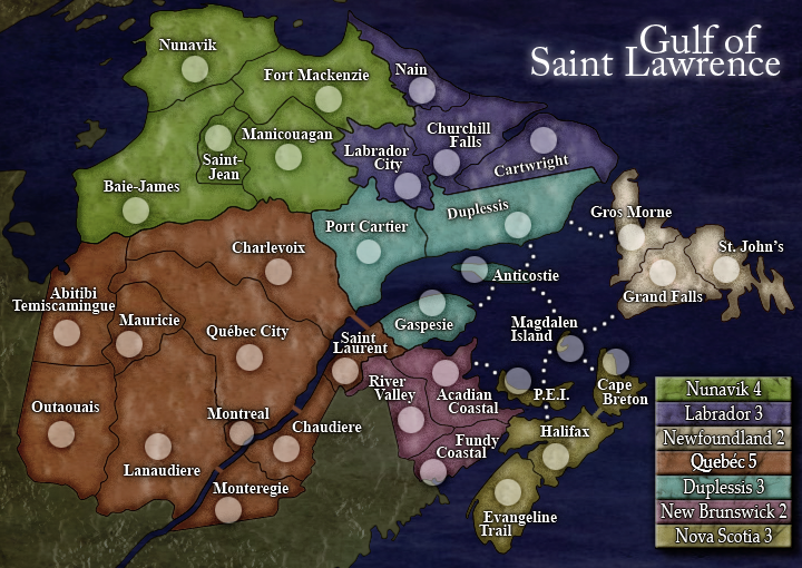
i'm not saying that there's been no research, but u have to put the effort in the right direction. the map that we have has excellent artwork, though it looks all wrong because it seems that the population is spread evenly throughout the area, whereas industry and development are supposed to be concentrated close to the st lawrence river, with the north being largely empty. not only that, but some of the quebec regions are in the wrong location.Unit_2 wrote:I split it up on how much research I did..Trust me I did alot as I do for every map I do.
The sea links are there for the best gameplay, also the same thing for the split-up of labrodor, not all of it is unhabited and what was I named with villages/cities in that territory, also Labrodor and Newfoundland might be the same prov. but the island is Newfoundland and Labrodor is on the mainland so they were split up to fit the gameplay more.
consider realism before adapting the map to gameplay, otherwise we end up with something a lot less convincing than it could be, given only a little more effort. why produce a misleading map, when u can have one that truly reflects the area, with gameplay that fits the character of the region?
newfoundland & labrador is one single province (and not an important one at that - there was even some discussion earlier on about whether to include it at all). there is no reason to split it up into two continents if it has only four territories. labrador being one territory is in line with its lack of importance: there are no cities in labrador. if u need three more territories to replace the merged labrador ones, then create three more in southern quebec; u have several real regions from which to choose (for example estrie, centre-du-quebec and laurentides).
in english, "magdalen island" ought to be magdalen islands (plural). this territory is part of quebec province, so put it in quebec. if, at a later stage, someone can show that we cannot produce good gameplay with the magdalen islands territory belonging to quebec, only then, with justification, should we move it somewhere else.
similarly, with the sea routes, start with real sea routes exclusively and add more only if gameplay is poor without more connections. the magdalen islands, although part of quebec, are connected regularly only to PEI. the difficulty of reaching the islands is a feature of the region that people who've been, or considered going, there will recognise. see what i mean about research?
three people have provided links to maps of quebec that have the regions in the right places (unlike our present map), yet quebec is virtually untouched from the first draft. i note that montreal has appeared now, which is good in principle, except it's in the wrong location.
http://www.theworldwidegourmet.com/trav ... ec/map.htm
i cannot fault the graphics. elsewhere on the map, there is much to do.
ian.
-
Unit_2
- Posts: 1834
- Joined: Sun Jan 14, 2007 12:59 pm
- Gender: Male
- Location: Pennsylvania, U.S.A, North America, Earth, Milky Way, Universe.
Ok, thats not wanting me to change it, this map has been re-worked for gameplay reasons, Newfoundland and Labrador can not be one cont. because they do not connect and were not going to re-arange it so it does because it doesn't in real life.
All the territorys in Labrador are named after the villages and their influince.
Magdalen Island is a pain in the butt...Magdalen Island will be changed to Magdalen Islands, also it will stay in Nove Scotia becuase the same reason for Labrador and Newfoundland, there not connected.
We added the sea lines again on better gameplay.
Montreal is NOT in the wrong location, its added in for the territorys: 19, 9 & 10, it can be seen on http://www.comeexplorecanada.com/quebec/
So like I said it is not going to be changed because of the bad gameplay. Period.
I think you made ian's point for him unit. The location of Montreal on the current map is at the location of 4 on the map you linked. That's Quebec City.
Also, just because areas are not connected does not mean they automatically cannot be part of the same continent. Though, the ramifications of a split continent would probably affect gameplay quite drastically.
Though I think some more thought or at least discussion should be put into everything that has been done. Right now the map is a mix of real life and made up stuff.
1. Quebec is a real life province that you've split into 3 continents.
2. Labrador and Newfoundland are apparently one province (according to people in the thread).
3.New Brunswick and Nova Scotia are their own provinces as well. Though Magdalen Islands has been added to Nova Scotia when it probably could easily just be moved to Duplesis.
I'm not really sure what should be done, but at the moment, like I said there's a lot of real life mixed with gameplay life (changes made for the map). At the very least I think it deserves discussion. I didn't know so much of this was happening until it was pointed out so my previous 'everything is ok' is revoked for the moment.
I don't think having a huge Quebec continent is the way to go. Maybe change the focus of your map. The map is called Gulf of St. Lawrence but the majority of the map is Quebec. Maybe just change the name of the map to suit the map you've made, but if you truly want a Gulf of St. Lawrence map then you should probably focus on that.
for instance.


Honestly, the gameplay of your current map is probably fine, but just because it has good gameplay doesn't mean everything is fine.
I doubt you'll be wanting to make huge changes, so one possible solution would be just to move Magdalen Island to the Duplessis continent and call it a day. Though, I'd wonder what people from that region would think about this map.
Also, just because areas are not connected does not mean they automatically cannot be part of the same continent. Though, the ramifications of a split continent would probably affect gameplay quite drastically.
Though I think some more thought or at least discussion should be put into everything that has been done. Right now the map is a mix of real life and made up stuff.
1. Quebec is a real life province that you've split into 3 continents.
2. Labrador and Newfoundland are apparently one province (according to people in the thread).
3.New Brunswick and Nova Scotia are their own provinces as well. Though Magdalen Islands has been added to Nova Scotia when it probably could easily just be moved to Duplesis.
I'm not really sure what should be done, but at the moment, like I said there's a lot of real life mixed with gameplay life (changes made for the map). At the very least I think it deserves discussion. I didn't know so much of this was happening until it was pointed out so my previous 'everything is ok' is revoked for the moment.
I don't think having a huge Quebec continent is the way to go. Maybe change the focus of your map. The map is called Gulf of St. Lawrence but the majority of the map is Quebec. Maybe just change the name of the map to suit the map you've made, but if you truly want a Gulf of St. Lawrence map then you should probably focus on that.
for instance.
Honestly, the gameplay of your current map is probably fine, but just because it has good gameplay doesn't mean everything is fine.
I doubt you'll be wanting to make huge changes, so one possible solution would be just to move Magdalen Island to the Duplessis continent and call it a day. Though, I'd wonder what people from that region would think about this map.
-
Unit_2
- Posts: 1834
- Joined: Sun Jan 14, 2007 12:59 pm
- Gender: Male
- Location: Pennsylvania, U.S.A, North America, Earth, Milky Way, Universe.
I know what you mean but the Islands but they are closes to Nova Scotia then Duplessis and Quebec is even too big right now so if we add the Islands into it it will be a mess.
About the name change i'm ok with it because like you said its not really just The Gulf of St. Lawrence, but what would we call it? "Eastern Canada"?
About the name change i'm ok with it because like you said its not really just The Gulf of St. Lawrence, but what would we call it? "Eastern Canada"?
-
Lone.prophet
- Posts: 1467
- Joined: Thu Oct 12, 2006 4:37 pm
- Location: Your basement Muahaha
ok for clearness
1) this map doesnt focus on population or economy but on regions (why come up with population desity?)
2) in the canada map labrador also isnt the same region as newfoundland
3) the bonus for quebec will become huge if the island is part of it too
4) start with real searoutes? why? we want a nice to play region maybe in the time this map plays there warent any ferries! so we made what looked best to us.
5) what to do with so much maps which focus population instead of nice evely spread territories?

unit_2
i re-read my post and the criticism sounds a bit harsh, as if i was really laying into u with heavy punches. sorry for the tone of what i said.
ian.
i re-read my post and the criticism sounds a bit harsh, as if i was really laying into u with heavy punches. sorry for the tone of what i said.
as a single continent, quebec province is too big for this map, so we're all agreed on splitting it into three.edbeard wrote:I don't think having a huge Quebec continent is the way to go.
edbeard wrote:Magdalen Islands has been added to Nova Scotia when it probably could easily just be moved to Duplesis. move Magdalen Island to the Duplessis continent
although i asked for magdalen islands to be moved to quebec, i actually meant to ask for it to be moved to one of the three continents comprising quebec province. duplessis continent is the most logical one.Unit_2 wrote:Quebec is even too big right now so if we add the Islands into it it will be a mess.
is it really better? better than what? islands, because of the water crossing, are more difficult for armies to attack than points that don't involve boats. on the map just now, with four sea routes, magdalen islands territory is more connected, and therefore more easily attacked, than most of the mainland territories.Unit_2 wrote:We added the sea lines again on better gameplay.
Unit_2 wrote:for gameplay reasons, Newfoundland and Labrador can not be one cont. because they do not connect and were not going to re-arange it so it does because it doesn't in real life.
labrador's lack of significance means it ought to be only one territory within the newfoundland continent. i don't see any gameplay reason to split labrador into four territories. extreme global warming's africa and pearl harbor's three aircraft continents are examples of continents where some or all territories do not border each other.edbeard wrote:Also, just because areas are not connected does not mean they automatically cannot be part of the same continent. Though, the ramifications of a split continent would probably affect gameplay quite drastically.
ian.
-
Lone.prophet
- Posts: 1467
- Joined: Thu Oct 12, 2006 4:37 pm
- Location: Your basement Muahaha
man come on stop this issues.iancanton wrote:labrador's lack of significance means it ought to be only one territory within the newfoundland continent. i don't see any gameplay reason to split labrador into four territories. extreme global warming's africa and pearl harbor's three aircraft continents are examples of continents where some or all territories do not border each other.
this map is the gulf before humans hit the earth think of that, so labrador is as important as the rest
this is another case of a map getting very close to completion andallof a sudden people start taking a more serious interest in it - Lone and Unit, you should feel flattered!
For starters, you can't very well say that this is a map of the region before humans walked the earth, because many of the regions are based on man-made political divisions, not geographic divisions. I don't know the region very well so I'll let you all hash this out, but from my point of view the territory names won't effect gameplay.
The concern about Quebec province being too big is a legitimate one - this is a small map with many easy-to-grab- bonuses, so a big bonus will probably be ignore in 98% of games. But there are solutions other than splitting it up. How about a +1 direct territory bonus for holding Montreal? It would certainly benefit whoever started there, and might get some side-action going in an otherwise dead region of the map.
And again, I don'tknow about the actual shipping routes between islands, and I dont care - this is war, and I don't think troops would be waiting around for the next commuter ferry to such and such island. I do, however, think it might be cleaner and make for better play if you lost at least one sea route - especially one of the sea routes to Magdalen, because with four attack routes that little island is going to be everybody's favorite punching bag whenit comes to playing this map!
Oh, and let's see how the small map looks.