-font is really bad, and unreadable in some locations
-borders of the continents (land) look too pixelated
High Seas Map [Abandoned - new project thread]
Moderator: Cartographers
98 posts
• Page 4 of 4 • 1, 2, 3, 4


![]() by ViscountGort on Thu Mar 01, 2007 7:21 pm
by ViscountGort on Thu Mar 01, 2007 7:21 pm
Oaktown thanks for bumping this thread, i appreciate it. and thanks to everyone for your input  .
.
I'm coming to the end of a major year-long project at uni, which is monopolising all my time at the moment, but i'll start working on a big update soon, incorporating a lot of the ideas put forward. Most of them have been really good .
.
Thanks again everyone, please keep any suggestions you have coming,
ViscountGort.
I'm coming to the end of a major year-long project at uni, which is monopolising all my time at the moment, but i'll start working on a big update soon, incorporating a lot of the ideas put forward. Most of them have been really good
Thanks again everyone, please keep any suggestions you have coming,
ViscountGort.
-

 ViscountGort
- Posts: 35
- Joined: Mon Jan 22, 2007 7:21 am
- Location: University of Durham, England


![]() by joystickgenie on Mon Mar 19, 2007 11:39 pm
by joystickgenie on Mon Mar 19, 2007 11:39 pm
You’re missing an ocean. As of 2006 all water under 60° S latitude is considered the southern ocean and not part of the Atlantic, Pacific or Indian oceans. But that’s just nit picking

Shinobi Nations
Comments are greatly appreciated.
-

joystickgenie
- Posts: 62
- Joined: Fri Feb 09, 2007 9:25 pm
![]() by luckiekevin on Tue Mar 20, 2007 1:15 am
by luckiekevin on Tue Mar 20, 2007 1:15 am
Amazing job!! Let's do this. This is just a beautiful map. Graphics are wonderful and fitting.
-

luckiekevin
- Posts: 272
- Joined: Fri Oct 13, 2006 10:08 pm
- Location: California


![]() by Master Bush on Tue Mar 20, 2007 1:31 am
by Master Bush on Tue Mar 20, 2007 1:31 am
This might become my favorite map when it comes out.
"You know what they say about Love and War...."
"Yeah, one involves a lot of physical and psychological pain, and the other one's War."
"Yeah, one involves a lot of physical and psychological pain, and the other one's War."
-

Master Bush
- Posts: 2387
- Joined: Thu Mar 02, 2006 10:50 pm


![]() by wrightfan123 on Tue Apr 03, 2007 6:33 pm
by wrightfan123 on Tue Apr 03, 2007 6:33 pm
Dude, I can't even read the text. Quit making it overly fancy and simplify it.
-

wrightfan123
- Posts: 601
- Joined: Sat Jan 06, 2007 2:58 pm
- Location: Looking over every baseball team's schedule to try to determine who will win the World Series.


![]() by oaktown on Thu Sep 06, 2007 8:11 pm
by oaktown on Thu Sep 06, 2007 8:11 pm
this is a big old BUMP from a project abandoned in April.
I've PM'd ViscountGort about this, but as he seems to have left us (no activity in over four months) I'm wondering if anybody would object to me taking over this project. I felt pretty close to the early development of this map, and while I'd like to start over on the graphics and we could certainly improve upon the bonus structure, I like the general idea.
thoughts?
Last edited by oaktown on Thu Sep 06, 2007 10:53 pm, edited 1 time in total.

-

oaktown
- Posts: 4451
- Joined: Sun Dec 03, 2006 9:24 pm
- Location: majorcommand


![]() by Keredrex on Fri Sep 07, 2007 12:34 am
by Keredrex on Fri Sep 07, 2007 12:34 am
First time Ive seen it .. Looks awesome dude..
Few suggestions....
1. I think you need to change the font.... maybe put up a few options for a vote to be cast....
2. I noticed that the connection between the caribean and cocos ridge has a faded look representing the opposing side... I think it should loof faded but have a similar color to the water... It would make the SHAPES of the Continents a bit more pronounced and easier to see which in turn makes the WATER territories easier to see
-

Keredrex
- Posts: 400
- Joined: Sun Jan 14, 2007 1:41 am
- Location: New York
![]() by ViscountGort on Sun Sep 23, 2007 10:58 am
by ViscountGort on Sun Sep 23, 2007 10:58 am
Hey oaktown, this is the first time i've logged on to cc in many months, apologies to you (and also keyogi) for not responding to the PMs you sent a while back.
Thought I'd let you know here that I have no objection to you taking over this project, and I hope it works out well for you.
I'll come back on now and then and see how you're getting on with it.
Thanks for PMing first by the way.
V Gort.
Thought I'd let you know here that I have no objection to you taking over this project, and I hope it works out well for you.
I'll come back on now and then and see how you're getting on with it.
Thanks for PMing first by the way.
V Gort.
-
ViscountGort
- Posts: 35
- Joined: Mon Jan 22, 2007 7:21 am
- Location: University of Durham, England
![]() by oaktown on Sun Sep 23, 2007 11:23 am
by oaktown on Sun Sep 23, 2007 11:23 am
ViscountGort wrote:Hey oaktown, this is the first time i've logged on to cc in many months, apologies to you (and also keyogi) for not responding to the PMs you sent a while back.
Thought I'd let you know here that I have no objection to you taking over this project, and I hope it works out well for you.
I'll come back on now and then and see how you're getting on with it.
Thanks for PMing first by the way.
V Gort.
Glad you approve, Gort... I still intend to work on this, although I've thrown myself into berlin and I'd like to move that along first. I think this will be a great map.
-
oaktown
- Posts: 4451
- Joined: Sun Dec 03, 2006 9:24 pm
- Location: majorcommand


![]() by cairnswk on Sat Nov 03, 2007 5:19 pm
by cairnswk on Sat Nov 03, 2007 5:19 pm
spinwizard wrote:IS THIS STILL RUNNING?
Why don't you contact Oaktown and see if oaktown is going to run with this map...he seems to have indicated that in the previous post.

* Pearl Harbour * Waterloo * Forbidden City * Jamaica * Pot Mosbi
-

cairnswk
- Posts: 11510
- Joined: Sat Feb 03, 2007 8:32 pm
- Location: Australia


![]() by oaktown on Sat Nov 03, 2007 5:26 pm
by oaktown on Sat Nov 03, 2007 5:26 pm
I'm willing to take it up because I think it'd be a fun project, but I got distracted by Duck and Cover. If somebody else wants to take it by all means do.
I actually started working on it a few weeks ago and I created a base image for the small map. I intend to get back to it, but again if somebody else wants to run with it you have my blessing!
here's all I've done... please, this is by no means intended as a request for feedback on the image!
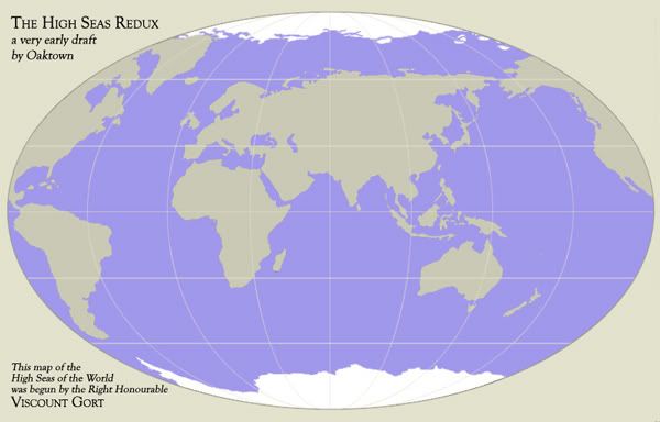
I actually started working on it a few weeks ago and I created a base image for the small map. I intend to get back to it, but again if somebody else wants to run with it you have my blessing!
here's all I've done... please, this is by no means intended as a request for feedback on the image!
-
oaktown
- Posts: 4451
- Joined: Sun Dec 03, 2006 9:24 pm
- Location: majorcommand
![]() by ViscountGort on Fri Nov 23, 2007 5:40 am
by ViscountGort on Fri Nov 23, 2007 5:40 am
I love it oaktown 
Hope you decide to pick it up again at some point. Duck & Cover looks great by the way.
All the best,
Rt. Hon. Viscount Gort
Hope you decide to pick it up again at some point. Duck & Cover looks great by the way.
All the best,
Rt. Hon. Viscount Gort
-
ViscountGort
- Posts: 35
- Joined: Mon Jan 22, 2007 7:21 am
- Location: University of Durham, England
![]() by oaktown on Wed Nov 28, 2007 2:52 pm
by oaktown on Wed Nov 28, 2007 2:52 pm
just wanted to BUMP this ahead of the Seven Seas map since that one is dead and this one isn't... I have every intention of working on it, unless somebody else thinks they can do it justice.
-
oaktown
- Posts: 4451
- Joined: Sun Dec 03, 2006 9:24 pm
- Location: majorcommand
Re: High Seas Map [new: v2.2]
![]() by Blitzaholic on Wed Dec 26, 2007 11:26 am
by Blitzaholic on Wed Dec 26, 2007 11:26 am
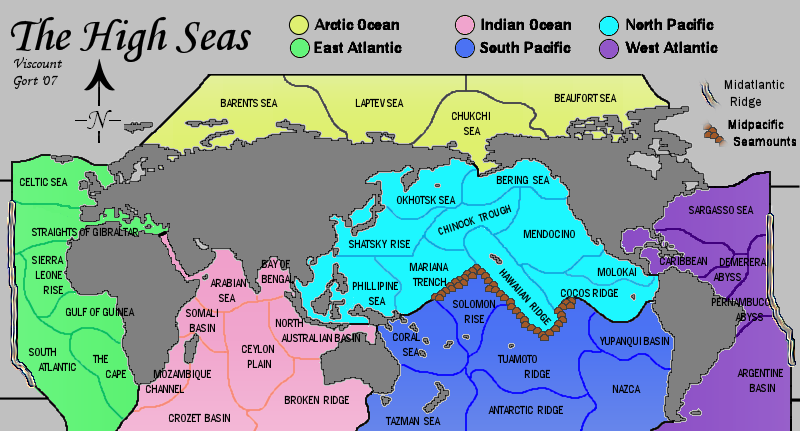
ViscountGort wrote:UPDATE:
Version 2.2:
There's no longer any need to vote in the poll as the layout of the map has now been set as it is, with the split down the Americas (i.e. neither poll option).
[Results of the poll for the records...
Where should the map be divided?
Down the midatlantic 39% [ 26 ]
Down the middle of Africa 60% [ 40 ]
Total Votes : 66 ]
===========================
=====ORIGINAL POST BELOW=======
===========================
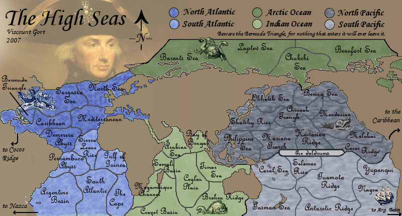
I thought it would be interesting to create a map in which the territories are not land areas at all, but rather regions of the oceans.
Below is a draft of the sort of structure I had in mind.
See above for current updated image.
The original can be viewed here.
6 continents, 40 countries. Bonuses still to be decided.
The Midtlantic Ridge and Midpacific Seamounts provide impassable boundaries lying between the E & W Atlantic and the N & S Pacific. These are both real geographical features.
Clearly it still needs considerable work visually, but I wanted to gauge early opinion on whether or not this could become a workable map.
Any comments welcome.
EDIT:: I've just discovered that another map exists in suspended development based on exactly the same idea, which I didn't know while I was producing this map or even when I posted it up here an hour ago. By coincidence some of the territories have the same or similar names.
I like it

-

Blitzaholic
- Posts: 23050
- Joined: Wed Aug 09, 2006 11:57 pm
- Location: Apocalyptic Area


98 posts
• Page 4 of 4 • 1, 2, 3, 4
Return to Melting Pot: Map Ideas
Who is online
Users browsing this forum: No registered users
|
|||||||
| Conquer Club is not associated with RISK online in any way. Copyright © 2006-2025 by Big Wham LLC | |||||||